We are the nation's premier federal science agency for the ocean and our coasts. An official @NOAA account: https://teapawt.org/t.co/HEaaXK2ikz
Joined October 2008
- Tweets10.9K
- Following267
- Followers205K
- Likes1.1K
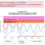
NOAA tide station observations indicate that the perigean spring tide and persistent easterly winds are contributing to coastal flooding across Southeast, with many stations measuring over two feet above normal high tide.
• Trident Pier, Port Canaveral, FL - 3.04 feet above MHHW (4th highest on record) - Station dates back to 1994
• Lake Worth Pier, Atlantic Ocean, FL - 2.70 feet above MHHW (new record) - Station dates back to 2010
• Kings Bay MSF Pier, GA - 2.61 feet above MHHW (5th highest on record) - Station dates back to 2022
• Virginia Key, FL - 2.54 feet above MHHW (3rd highest on record) - Station dates back to 1994
• South Port Everglades, FL - 2.52 feet above MHHW (new record) - Station dates back to 2018
• Mayport (Bar Pilots Dock), FL - 2.40 feet above MHHW (9th highest on record) - Station dates back to 1995
• Vaca Key, Florida Bay, FL - 2.27 feet above MHHW (4th highest on record) - Station dates back to 1971
• Key West, FL - 2.23 feet above MHHW (4th highest on record) - Station dates back to 1913
Elevated water levels are expected to continue for the next few days as strong easterly winds are forecast to persist.
To view real-time water level conditions at locations near you, visit NOAA’s Coastal Inundation Dashboard: tidesandcurrents.noaa.gov/in…
NOAA tide station observations indicate oceanic Kelvin waves are contributing to new/broken water level records along the California coast, including some of the highest readings in over a century.
San Diego, CA - 2.80 feet above mean higher high water (MHHW) - Station dates back to 1906
La Jolla, CA - 2.65 feet above MHHW - Station dates back to 1924
Los Angeles, CA - 2.70 feet above MHHW - Station dates back to 1923
Santa Barbara, CA - 2.65 feet above MHHW - Station dates back to 1974
These elevated water levels are the result of above-normal tides—caused by the full moon and perigean spring tide (when the Moon is closest to the Earth)—in addition to impacts from El Niño-driven Kelvin waves.
More record-breaking water levels are possible today, with a continued risk of flooding and other coastal hazards.
To view real-time water level conditions at locations near you, visit NOAA’s Coastal Inundation Dashboard: tidesandcurrents.noaa.gov/in…
NOAA released the new Coastal Ocean Reanalysis (CORA) dataset for the U.S. West Coast, Hawaii, and southern Alaska, and a new Experimental High-Resolution High Tide Flooding Outlook. This dataset and Experimental Outlook advance NOAA’s ability to better serve our nation’s coastal communities by providing data to support coastal flood planning and mitigation efforts. Learn more at: oceanservice.noaa.gov/news/o…
El Niño driven Kelvin waves continue to impact the California coast, moving north towards Oregon and Washington. More Kelvin waves are likely to occur throughout the fall and winter during El Niño.
These large-scale oceanic waves raise water levels and temperatures along the coast, increasing the risk of flooding and other coastal hazards. Wind, waves, and storms can worsen these potential impacts.
Visit NOAA’s Coastal Inundation Dashboard to monitor real-time conditions at locations near you: tidesandcurrents.noaa.gov/in…
NOAA's Ocean Service retweeted
Happy 54th anniversary to the National Marine Sanctuaries Act! 💙
Since 1972, the system has grown into a network of 18 national marine sanctuaries conserving more than 629,000 sq miles of spectacular ocean and Great Lakes waters. 🌊
🔗Learn more: sanctuaries.noaa.gov/
NOAA's Ocean Service retweeted
The U.S. Ocean Enterprise is 1,830 businesses strong! They support the rising demand for ocean and Great Lakes data & information — read more in The U.S. Ocean Enterprise in 2025 report! oceanservice.noaa.gov/news/o…
NOAA's Ocean Service retweeted
It's #HagfishDay! #Hagfish are fascinating marine animals known for their twisty abilities and copious slime production. This 2018 video shows a Pacific hagfish (Eptatretus stoutii) living inside a sponge in Monterey Bay National Marine Sanctuary: bit.ly/3WEJgnO
NOAA's Ocean Service retweeted
Some marine debris can be picked up by hand. Some requires cranes, divers, flotation devices, or even helicopters. Learn about how our partners address large-scale debris by floating it, lifting it, swimming it, and flying it out. @noaaocean blog.marinedebris.noaa.gov/f…
Do you live in California? Are you wondering how El-Nino driven Kelvin waves might impact coastal water levels?
NOAA’s Coastal Inundation Dashboard can help you stay informed! Use the dashboard to:
•Monitor real-time water levels at NOAA tide stations
•View real-time wave height and direction observations from offshore buoys
•Access webcam imagery to see real-time conditions
Visit the NOAA’s Coastal Inundation Dashboard to get started: tidesandcurrents.noaa.gov/in…
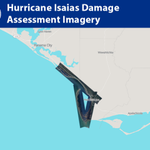
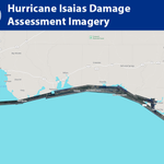
Flights over the area affected by Hurricane Isaias have concluded. The final update includes additional imagery from the Port Saint Joe area: storms.ngs.noaa.gov/storms/i…
Flights over the area affected by Hurricane Isaias continue. The latest update includes Pascagoula, Biloxi, Gulfport, Bay St. Louis, Waveland and Chandeleur Islands: storms.ngs.noaa.gov/storms/i…
Flights over the area affected by Hurricane Isaias continue. Today’s update includes Pensacola Bay, Mobile Bay and Gulf Islands National Seashore including Dauphin Island. storms.ngs.noaa.gov/storms/i…
Flights over the area affected by Hurricane Isaias continue. This evening’s update includes the coast from Gulf Shores to Panama City: storms.ngs.noaa.gov/storms/i…
The first images from NOAA's Hurricane Isaias damage assessment flights are now available. Today's flight covered the Port Saint Joe area: storms.ngs.noaa.gov/storms/i…
For a full list of NOAA resources, visit: noaa.gov/isaias
Water levels are already rising due to Hurricane #Isaias across southeastern Louisiana eastward to the western Florida Panhandle. View real-time water level and meteorological data at: tidesandcurrents.noaa.gov/in…
NOAA is monitoring water levels and winds for Tropical Storm Rachel, which is expected to approach the coast of the norther Baja California Peninsula and southern California Saturday night. View real-time water level and meteorological data: tidesandcurrents.noaa.gov/in…
NOAA continues to monitor water levels and winds for Hurricane Isaias as it approaches the northern Gulf coast. View real-time water level and meteorological data:
tidesandcurrents.noaa.gov/in…
NOAA is monitoring water levels and winds for Tropical Storm Isaias, expected to strengthen into a strong hurricane before approaching the northern Gulf Coast on Friday. View real-time water level and meteorological data: tidesandcurrents.noaa.gov/in…
More storm information: noaa.gov/isaias
NOAA recently added a new tide station to the Los Angeles/Long Beach Physical Oceanographic Real-Time System (PORTS). It provides local tidal information to support safe and efficient operations in this major maritime hub. View the data: tidesandcurrents.noaa.gov/po…