

@BeefUSA
🇺🇸Account based in
About this account
- Account based in
- United States
- Connected via
- United States App Store
Account-level information from X, not a live location or the device used for a specific post.
The definitive voice of U.S. cattle & beef producers since 1898. Fighting to keep our industry profitable, sustainable, and strong for generations to come.
Denver, CO and Washington, DC
Joined July 2009
- Tweets11K
- Following1.4K
- Followers34.3K
- Likes10.2K
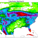


Some important weather concerns are developing for next week, but the impacts will vary a lot.
The Southern Plains and Four Corners are probably the biggest areas to watch. Winter wheat planting is underway with serious soil moisture deficits. Topsoil is rated short to very short across 89% of Texas, 88% of Oklahoma, 66% of Kansas, and 81% of Colorado. Extreme to exceptional drought also remains across portions of the central and western High Plains.
Now, a potentially wetter pattern is starting to show up.
A slow-moving system will develop near the Four Corners early next week. There’s also the possibility that moisture from Hurricane Polo hitting Mexico gets pulled north into this system. That could bring several days of rain and storms to parts of the Four Corners and western Plains.
For winter wheat, meaningful rainfall would be welcome. The problem is placement. Some of the driest areas farther south could still miss the better moisture, while heavier rain becomes focused farther west or north.
The situation is almost reversed across the Upper Midwest and western Corn Belt.
Parts of the region remain drought-stressed, but southern Minnesota, eastern Iowa, southern Wisconsin, and northern Illinois have recently been very wet. Iowa’s corn and soybean harvest is already running behind schedule after repeated rainfall and limited fieldwork.
Another round of moderate to heavy rain may spread from the Plains into the Upper Midwest and Mississippi Valley early to midweek. If that falls on the already-wet areas, harvest delays and crop-quality concerns could increase.
To watch: A slower Four Corners system could focus more beneficial rain over drought-stricken areas of the Southwest and western Plains. A faster-moving system could push precipitation east sooner, potentially adding rain to areas where harvest is already struggling with wet fields. @MattMakens


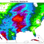
Heavy rain and flash flooding will be the weather story to watch over the next two weeks. Shown below is the precipitation estimate coming for the next week.
This weekend, the heavier rain threat stretches from northeastern Kansas and northern Missouri into the Midwest and Northeast, before shifting toward the mid-Atlantic and Southeast Coast early next week.
By Tuesday, monsoonal storms ramp back up across New Mexico and the Texas Panhandle. Repeated heavy rain could lead to flash flooding for some.
Looking ahead to Sept. 24-30, the Four Corners and East Coast remain the areas to watch for additional heavy rain. There’s also a possibility of tropical development north of the Bahamas, which could bring additional heavy moisture to the East Coast.
Much of the country east of the Rockies is expected to run warmer than normal, but significant heat impacts begin to subside.
Bottom line: Flooding is the main concern, with several parts of the country potentially dealing with repeated rounds of heavy rain through late September.

Your operation has enough to manage already.
We'll help you simplify daily beef operations and give you more time to focus on what matters most. We deliver solutions for every aspect of your feedyard, enabling you to produce safe, wholesome products more efficiently and profitably.
Learn more at:
microtechnologies.com/feedya…
#BeefProducers #BeefCattle #CattleProducers #Ranching #CattleRanching #BeefIndustry #MWIAnimalHealth #FarmManagement #ProducerSolutions #AgInnovation
National Cattlemen's Beef Association retweeted

New Meat Demand Monitor data: origin & traceability claims still rank 11 of 12 in what drives meat purchases, even with all the headlines. Taste, freshness, price and safety still win. @TonsorGlynn breaks it down.
agricultureofamerica.com/202…

NCBA's Ethan Lane on recent events in the cattle industry:
“It’s having ramifications on our supply chain. It’s taking money out of cattle producers’ pockets. It’s laying waste to what was a really strong market for our animals. People are really, really going to the mat to take the good out of this supply chain and this market right now for their own political purposes. And it’s really disappointing to see.”

NCBA's Ethan Lane (@BeefUSA) doesn't hold back on Thursday's @AoA_TalkShow: beef imports, MCOOL, and a response to Lutnick's recent data center/cattle water comment.
"More questions than answers" was how Lane summarized the broader moment for the industry. 🎥
agricultureofamerica.com/202…

The odds of a potentially historic El Niño continue to increase.
NOAA’s Climate Prediction Center released its September ENSO update today, and El Niño continues to strengthen across the tropical Pacific.
Current data support a 75% chance that this event will become the strongest on the modern record. Last month, that probability was 69%.
That’s significant, but there’s an important distinction.
A historically strong El Niño does NOT automatically mean historically heavy snow, extreme cold, or any other specific outcome where you live. Stronger El Niño events generally increase confidence in some of the typical El Niño impacts, but they don’t guarantee them. The PDO, location of the warmest Pacific water, atmospheric circulation and other parts of the pattern will all matter as we get closer to winter.
So today’s update strengthens the case for an exceptional El Niño. It does not settle the winter forecast.
Our @mattmakens and @talkingaglane recently sat down to discuss the winter forecast in the latest Cattlemen's Call Podcast, and a regional weather outlook is coming to you soon in the Fall Directions magazine.
#ElNino #ENSO #WinterWeather #Weather #Winter2026

Just this week, we've seen the Secretary of Commerce claim on national television that cattle production is America's largest user of water while defending data center development.
We've also seen R-CALF align with organizations such as Food & Water Watch and the Farm Action Fund, while Joe Maxwell continues to speak as a voice for farmers and ranchers despite longstanding ties to animal rights activism.


As discussions around policy impacting the cattle industry continue, it's important to remember what's at stake for cattle producers and rural communities across America. Lower beef prices don’t benefit cattle producers and there is little support for data centers in rural America.
September will be a month to watch as we transition from our hot/dry summer pattern to one driven by El Niño.
The month starts with late-summer heat holding on across the central and southern U.S., especially the central/southern Plains and mid/lower Mississippi Valley. That heat may hang on into the second week of September before the pattern shifts and relief becomes more likely.
Meanwhile, the West turns cooler and wetter. Monsoonal moisture, potentially mixed with tropical moisture from the eastern Pacific, could bring periods of heavy rain to the Southwest and West. Farther north, a stronger storm system may bring heavy rain and severe storms to the northern Rockies, northern Plains and Upper Midwest early in the month.
Looking at September as a whole, the precipitation outlook shown on the map favors a wetter month across much of the West, including California, the Southwest, the Intermountain West, and the Rockies. Wetter conditions are also favored around the Upper Midwest and Great Lakes.
Below-normal precipitation is favored across parts of the central Plains and central Mississippi Valley, where persistent heat and limited rainfall likely worsen ongoing drought before a wetter turn later in the month through October.
So, the big September theme is a split pattern: cooler and wetter at times in much of the West, hot and relatively dry through the central U.S., but transitioning relatively soon. @MattMakens provides free updates for NCBA members. Visit makensweather.com/join to get the weekly updates.

Pasture and ranges are in rough shape right now and the numbers back it up. In late July, 29% of the country's pasture and range was rated good to excellent, down from 45% a year earlier. By mid-August, that number had dropped to 25%, with 52.7% of the Lower 48 in drought.
Spring wheat got hit hard. Acres in drought jumped from 63% on Aug. 11 to 76% just a week later, the fastest one-week jump in years.
This week: severe drought is spreading across northwestern Wisconsin and eastern Minnesota. Extreme drought is holding across the West and Northwest. Exceptional drought, the worst category on the scale, keeps expanding out of the Texas and Oklahoma panhandles; keep an eye on this area, as it may expand eastward, connecting to Arkansas in the week(s) ahead.
This pattern hasn't really reversed direction once since late June. But changes will arrive through September and fall.
Where do things stand where you are? @MattMakens


NCBA supports more competition, more opportunities for small & regional processors, and eliminating unnecessary regulations but weakening federal meat inspection & food safety standards isn’t the answer.
America’s cattle producers have earned consumer trust in U.S. beef over generations. That trust, and the gold standard food safety system behind it, shouldn’t be put at risk for a short-term political fix.
Washington should focus on reducing legitimate regulatory burdens, lowering input costs, protecting the herd from foreign animal disease & expanding processing opportunities—not managing the cattle business.
National Cattlemen's Beef Association retweeted

"Every time there is some sort of announcement, he introduces uncertainty – and the last thing in the world that cattle markets like is uncertainty."
@BeefUSA CEO Colin Woodall criticizes President Trump's temporary pause on beef import tariffs:
cnbc.com/video/2026/08/24/na…

☀️ Heat will be the big weather story through the end of August.
From Aug. 24-26, triple-digit heat will continue across the Southern Plains and Lower Mississippi Valley, with very warm nights offering little relief. Parts of the Desert Southwest could top 110°F. The two maps show record temperatures and the Cattle Health Index.
By Aug. 27-31, the heat could become even more intense and long-lasting. The Southern Plains may see temperatures above 100°F with heat indices above 110°F, while parts of the Desert Southwest could reach 110-120°F. The heat may also expand farther north into the Interior West, Plains and Mississippi Valley.
⛈️ It won't be all about the heat. Storms could bring isolated flash flooding to the Intermountain West/Rockies, while rain and storms spread into parts of the Midwest, Great Lakes, Southeast and Eastern Seaboard. Heavy rain is also possible from coastal South Carolina and the mid-Atlantic into parts of the Northeast later in the period.
🔥 Continued heat and dry conditions could also worsen drought and increase fire weather concerns across parts of the central U.S.
#Heat #ExtremeHeat #Weather #WeatherUpdate #FlashFlooding #Drought @MattMakens


No cow-calf producer in America is asking for increased imports. Undercutting American farmers and ranchers with inferior product from foreign competitors does nothing to create market confidence or encourage rebuilding the herd.

The Trump Administration's repeated whiplash on trade policy and beef imports has real impacts on cattle producers in rural America. USDA created and promoted a stronger “Product of the USA” label, only to abandon it and decide that MCOOL was the only option.
It has been a hot, dry summer for most of the herd. Are you sick of it yet?
The summer pattern is dictated by the monsoonal ridge/high ("heat dome"), which shifts where rain falls and where the hottest temperatures settle. This feature lasts a long time and slowly meanders across the central to western U.S.
This "heat dome" is unlikely to weaken much anytime soon, which means more heat and drought stress for many.
Here is the temperature outlook from @mattmakens for the next four weeks... that's a lot of red!
