

Official X account for the National Weather Service Climate Prediction Center. Details: https://teapawt.org/t.co/Sprfmgcmqc
- Tweets6.2K
- Following380
- Followers67.9K
- Likes29
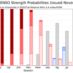



ALT A bar chart showing the chance of El Niño (red bars), ENSO-Neutral (grey bars), and La Niña (blue bars) provided for 9 upcoming, overlapping 3-month seasons (each letter represents a month, for example, F = February). The color shading within the bars indicates the chances of different categories of El Niño or La Niña strength (weak, moderate, strong, and very strong). Alternatively, the table at the internet address below presents the percent chances of each strength category in numerical form. https://cpc.ncep.noaa.gov/products/analysis_monitoring/enso/roni/strengths/

ALT The Climate Prediction Center 8 to 14 Day Precipitation Outlook issued November 9, 2026, and valid for November 17 to November 23, 2026. Chances for above-normal precipitation are indicated across the majority of the country, including California, the Southwest, the Great Basin/Intermountain West, the Rockies, the Plains, the Mississippi Valleys, the Great Lakes, and the Southeast. The highest probabilities (60 to 70 percent) are centered over the Central and Southern Plains. Near-normal precipitation is forecast for the northernmost parts of the Northwest Pacific, Northern Great Basin, and Northern Rockies, along with a secondary band stretching across parts of the Ohio Valley, Tennessee Valley, and southern Middle Atlantic. Below-normal precipitation is forecast for the Northeast and the northern Middle Atlantic with probabilities reaching 40 to 50 percent over northernmost parts of New England, and 33 to 40 percent chances over the rest of the Northeast and Middle Atlantic.

ALT Potential atmospheric river activity could bring enhanced moisture to much of the West Coast during mid-November. Strong surface low pressure just north of the region could also likely drive high winds along the immediate coastline. A fair amount of uncertainty continues regarding the exact timing and magnitude of rainfall and winds. Moderate risk (40 to 60%) of heavy precipitation shown for Nov 14 to 15 across parts of southwestern OR and northern/central CA, while a slight risk (20 to 40%) extends to Nov 17 across the West Coast into the Southwest, Great Basin, and Southern Rockies. A moderate risk of high winds shown for the immediate West Coast Nov 14 to 15 and broader slight risk across the West until Nov 17. Moderate risk of heavy snow for higher elevations of the Klamath and Sierra Nevada Nov 14 to 15. Slight risks of heavy snow to Nov 17 for high elevations of the Cascades, Klamath, and Sierra Nevada, Northern Intermountain, Great Basin, and Central and Northern Rockies.

ALT Potential atmospheric river activity could bring enhanced moisture to much of the West Coast during mid-November. There is increased uncertainty regarding the potential for heavy precipitation. Strong surface low pressure north of the region will also likely drive high winds along the immediate coastline. Moderate risk (40 to 60%) of heavy precipitation shown for Nov 13 to 15 across parts of the Pacific Northwest and northern/central California, with slight risk (20 to 40%) extends to Nov 17 across the West Coast into the Desert Southwest, Great Basin, and Southern Rockies. High winds are possible across much of the West, including a moderate risk along the immediate West Coast Nov 13 to 15 and broader slight risk to Nov 17. Moderate risk of heavy snow across the higher elevations of the Klamath and Sierra Nevada Nov 13 to 15. Slight risks of heavy snow extend to Nov 17 for these areas as well as the Northern Intermountain, Great Basin, and Central and Northern Rockies.

ALT Heavy Precipitation, High Wind, and Flooding risks for the western United States, valid November 10-16. There is a high risk (over 60 percent) of heavy precipitation across the West Coast states from northern California through the Northwest November 10-12, accompanied by the potential for flooding in lower elevations. A moderate risk (40 to 60 percent) extends through November 14 and includes central California. A moderate risk (40 to 60 percent) of high winds extends along coastal portions of the West Coast November 10-14. Slight risks of heavy precipitation and high winds cover large parts of the West through November 16. Heavy Snowfall risks for the western United States, valid November 10-16. A high risk (over 60 percent) of heavy snow is indicated across the Washington Cascades 10-12, with a moderate risk (40 to 60 percent) extending farther south to include the southern Cascades, Klamath, and Sierra Nevada ranges through November 14. A slight risk continues through November 16

ALT The Climate Prediction Center 8-14 Day Hazards Outlook released October 26, 2026 for the period of November 3 to 9, 2026 indicates a moderate risk (40 to 60 percent chance) of heavy precipitation for portions of southwestern Oregon and northwestern California November 6 to 8, and a moderate risk of heavy snow for portions of the northern Sierra Nevada and southern Cascades Nov 6 to 8. Slight risk (20 to 40 percent chance) of heavy precipitation is posted for portions of the Pacific Northwest and Northern California Nov 5 to 9, along with slight risks of heavy snow for the Cascades, Klamath and northern Sierra Nevada ranges Nov 5 to 9.

ALT The 8 to 14 Day Precipitation Outlook Issued October 22, 2026 valid October 30 to November 5, 2026 depicts broad chances of above-normal precipitation over much of the U.S. 60 to 70 percent chances of above-normal precipitation are indicated over coastal southern California, southeastern Arizona, southern New Mexico, and southwestern Texas. 50 to 60 percent chances of above-normal precipitation cover much of California, stretching through the southern half of Nevada and Utah, into Oklahoma and most of Texas. Broader 40 to 50 percent chances and 33 to 40 percent chances of above-normal precipitation cover much of the U.S., with the exception of Washington, northern Idaho, Montana, North Dakota, northern Minnesota, and New England, where near-normal precipitation is favored.

ALT The Climate Prediction Center’s 8-14 Day Precipitation Outlook issued October 21, 2026, and valid October 29-November 4, depicts greater than a 60 percent chance of above-normal precipitation across much of central and southern California and more than a 50 percent chance of above-normal precipitation throughout the Southwest.

ALT The Drought Outlook was released on October 15, 2026 and its valid period begins on October 15, 2026 and ends on January 31, 2027. This product depicts the forecast change in drought category, such as removal, improvement, no changes, development, or worsening.

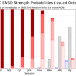
ALT A bar chart showing the chance of El Niño (red bars), ENSO-Neutral (grey bars), and La Niña (blue bars) provided for 9 upcoming, overlapping 3-month seasons (each letter represents a month, for example, F = February). The color shading within the bars indicates the chances of different categories of El Niño or La Niña strength (weak, moderate, strong, and very strong). Alternatively, the table at the internet address below presents the percent chances of each strength category in numerical form. https://cpc.ncep.noaa.gov/products/analysis_monitoring/enso/roni/strengths/

ALT Climate Prediction Center 6 to 10 day precipitation outlook across the southeastern Contiguous United States valid October 8-12 2026. Probabilities of above normal rainfall exceeds 60 percent across much of the Florida Panhandle and above 50 percent across much of the remainder of the eastern Gulf Coast and Southeast.

ALT Climate Prediction Center Risk of Heavy Rain and Flooding valid for the period of October 10-16 2026. A Moderate Risk of Heavy Rain is indicated across northern Florida and adjacent areas of the Gulf Coast and southern Georgia and Alabama, with flooding possible across many of these same areas.

ALT A bar chart showing the chance of El Niño (red bars), ENSO-Neutral (grey bars), and La Niña (blue bars) provided for 9 upcoming, overlapping 3-month seasons (each letter represents a month, for example, F = February). The color shading within the bars indicates the chances of different categories of El Niño or La Niña strength (weak, moderate, strong, and very strong). Alternatively, the table at the internet address below presents the percent chances of each strength category in numerical form. https://cpc.ncep.noaa.gov/products/analysis_monitoring/enso/roni/strengths/

ALT 6 to 10 Day Precipitation Outlook issued September 1, 2026, valid September 7 to 11, 2026. A 50 to 60 percent chance of above-normal precipitation covers much of the interior West, including eastern California, the Northern and Central Great Basin, the Southwest, and parts of the Northern and Central Rockies. A 40 to 50 percent chance of above-normal precipitation spans parts of the Pacific Northwest, California, Southwest, and Northern and Central Plains. A broad area of 33 to 40 percent chance of above-normal precipitation covers much of the western and central United States.

ALT 8 to 14 Day Precipitation Outlook issued September 1, 2026, valid September 9 to 15, 2026. A broad area of 33 to 40 percent chance of above-normal precipitation covers much of the western United States, excepting the Olympic Peninsula in the Northwest Pacific region, which is forecast to have near-normal precipitation. 40 to 50 percent chance of above-normal precipitation stretches from the Southwest northward through the Central and Northern Great Basin into parts of the Northern Rockies. A 50 to 60 percent chance of above-normal precipitation covers southern California and southwestern Arizona.

ALT The Climate Prediction Center 8 to 14 day Precipitation Outlook issued August 31, 2026 for the period of September 8 to 14, 2026 indicates a greater than 60 percent chance of above normal precipitation for the Big Island of Hawaii and a greater than 50 percent chance of above normal precipitation for the remainder of the Island Chain.


ALT Dangerous heat will persist across the Southwest through Friday with daytime highs of 110-115°F. Expect numerous daily record highs and Major to Extreme HeatRisk. Little overnight relief is expected as many areas may not cool below 80°F for several nights in a row. Temperatures return to near-normal levels over the weekend. Dangerous heat will build across the Southern Plains again beginning this weekend, and persist into next week. Daytime highs of 95-105°F, with limited recovery at night due to lows only in the mid-70s (°F), will result in widespread Major to Extreme HeatRisk. Increased chances for extreme heat continue into early Sep. A moderate risk (40-60% chance) of extreme heat remains highlighted across the south-central CONUS and Lower and Middle Mississippi, and Tennessee Valleys, Sep 4-6. Limit outdoor activity, stay hydrated, and ensure access to A/C or cooling centers. Check on vulnerable family, friends, and neighbors. Never leave kids or pets unattended in vehicles.


ALT The Climate Prediction Center Global Tropics Hazards Outlook released August 18, 2026 for the valid period of August 26, 2026 through September 8, 2026. More than a 60 percent chance of tropical cyclone development is indicated for the East Pacific from August 26 to September 1; with a 40 to 60 percent chance closer to the Central Pacific. From September 2-8, a 20 to 60 percent chance of tropical cyclone development is designated for the East and Central Pacific. This product is updated once per week and targets broad scale conditions integrated over a 7-day period for US interests only. This graphic does not indicate track or potential landfall of tropical systems. Refer to the National Hurricane Center (NHC) at www.nhc.noaa.gov.

ALT Key Message for Extreme Heat and Rapid Onset Drought over the Southern U.S. issued Aug 17, 2026. For Aug 25 to 31, over 60 percent chances of above-normal temperatures are indicated across much of the Southwest, Central, and Southern U.S. 70 to 80 percent chances of above-normal temperatures are indicated over southwestern Texas. A high risk (greater than 60 percent chance) of extreme heat covers the parts of the Southern and Central Plains, adjacent areas of the Mississippi Valley Aug 25 to 26. Moderate risk (40 to 60 percent chance) of extreme heat indicated for much of the Central and Southern Plains, Rockies, Desert Southwest, parts of the Middle and Lower Mississippi Valley, and adjacent parts of the Southeast Aug 25 to 28. Slight risk (20 to 40 percent chance) of extreme heat indicated for portions of the Southwest, Great Basin, Rockies, Central and Southern Plains, Middle and Lower Mississippi and Tennessee Valleys, and Southeast Aug 25 to 31. Rapid Onset Drought (ROD) risk for

ALT Key Message for Prolonged Southern U.S. Heat Wave and Rapid Onset Drought issued August 10, 2026, updated August 13, 2026, for August 21–27. A greater than 60 percent chance of above-normal temperatures is forecast across the Southern Plains, Lower Mississippi and Tennessee Valleys, and Southeast for August 21–27. A high risk (greater than 60 percent chance) of extreme heat affects the Central/Southern Plains and Middle/Lower Mississippi Valley August 21, with heat indices possibly reaching over 105 to 110 degrees Fahrenheit and near-record overnight lows possible. A moderate risk (40 to 60 percent) is indicated for the Central and Southern Plains, Middle and Lower Mississippi and Tennessee Valleys, and Southeast August 21 to 23, and a slight risk indicated for portions of the Central and Southern Plains, Middle and Lower Mississippi, Ohio, and Tennessee Valleys, Southeast, and southern Mid-Atlantic August 21 to 27. Rapid Onset Drought is underway across the Central/Southern Plains and

ALT A bar chart showing the chance of El Niño (red bars), ENSO-Neutral (grey bars), and La Niña (blue bars) provided for 9 upcoming, overlapping 3-month seasons (each letter represents a month, for example, F = February). The color shading within the bars indicates the chances of different categories of El Niño or La Niña strength (weak, moderate, strong, and very strong). Alternatively, the table at the internet address below presents the percent chances of each strength category in numerical form. https://cpc.ncep.noaa.gov/products/analysis_monitoring/enso/roni/strengths/