

KMOV 4 Meteorologist
Joined February 2021
- Tweets1.4K
- Following115
- Followers327
- Likes1.4K
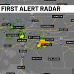


Duck Duck…Goose!
Check out this return on the radar, this is most likely from migrating waterfowl pushing through this morning with winds to guide them south.

Loving this shot of Downtown STL this morning! Grab a coat, things are chilly, back into the mid-40s.

2
64
Chance Gotsch retweeted

We have a low severe risk on Tuesday, not much storm fuel to work with as storms move through STL mainly in the afternoon to evening. The strongest storms will be 2pm to 7pm, strong winds the main risk


From First Alert 4... New Severe Thunderstorm Warning issued for Jefferson, Monroe. Track the storms on radar at bit.ly/3v79dLm #FirstAlert4
2
1
75
From First Alert 4... New Tornado Warning issued for Richland, Clay. Seek shelter in this area! Track the storms on radar at bit.ly/3v79dLm #FirstAlert4
From First Alert 4... New Tornado Warning issued for Clay, Effingham. Seek shelter in this area! Track the storms on radar at bit.ly/3v79dLm #FirstAlert4
72
From First Alert 4... New Severe Thunderstorm Warning issued for Fayette. Track the storms on radar at bit.ly/3v79dLm #FirstAlert4
From First Alert 4... New Severe Thunderstorm Warning issued for Pike. Track the storms on radar at bit.ly/3v79dLm #FirstAlert4
64
Chance Gotsch retweeted
So far we have tied a 95 year old record high today (still time to break it). Current temp is 97, record is 97 from 1931 #FirstAlert4

From First Alert 4... New Severe Thunderstorm Warning issued for St. Charles. Track the storms on radar at bit.ly/3v79dLm #FirstAlert4


From First Alert 4... New Severe Thunderstorm Warning issued for St. Louis, St. Louis City, Jefferson, Monroe. Track the storms on radar at bit.ly/3v79dLm #FirstAlert4
1
65
From First Alert 4... New Severe Thunderstorm Warning issued for Franklin, Warren. Track the storms on radar at bit.ly/3v79dLm #FirstAlert4
1
2
90
From First Alert 4... New Severe Thunderstorm Warning issued for St. Francois. Track the storms on radar at bit.ly/3v79dLm #FirstAlert4
48
