

Assistant professor at @goteborgsuni : https://teapawt.org/t.co/P8BEo04XRJ Observational Oceanographer ⚗️🌊🛥️. He/him. Views my own. Open door 🌎🌏🌍
- Tweets617
- Following892
- Followers794
- Likes2.2K








ALT A selfie of Yixi, who smiles at the camera while wearing a fluorescent cold weather jacket and bobble woolly hat. She stands in a bright white Antarctic landscape.


ALT Sea level data gathered Jan. 21 in the Gulf Stream by SWOT’s KaRIn instrument. The ocean is grey and the land is white. A data overlay, generated from SWOT’s measurements, shows up as a colorful stripe on the right side of the image. A color code at the bottom of the image shows that color in the data stripe corresponds to sea surface height anomaly in meters, where dark blue is less than or equal to 0.25, white is 0, and dark red is greater than or equal to 0.25.

ALT Sea level data generated from 7 active nadir altimeter missions shows up as a colorful stripe that is fuzzier than the first image. A color code at the bottom of the image shows that color in the data stripe corresponds to sea surface height anomaly in meters, where dark blue is less than or equal to 0.25, white is 0, and dark red is greater than or equal to 0.25.


ALT The expedition left Cape Town in early March on the US research vessel Roger Revelle.


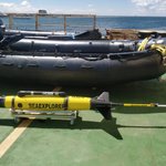
ALT The researchers are using the most modern technologies and sensors available to execute this research, such as underwater gliders.

ALT Researchers are now for the first time measuring the fine-scale ocean currents in the Cape Cauldron region to better understand the mechanisms in the critical part of the Atlantic known as the "Agulhas Leakage".


