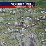

A dense fog advisory is now in place for Freestone, Navarro, Limestone, and Falls County until 11 am.
Increasing clouds and humidity expected through the rest of the week. A couple of disturbances bring better rain chances Friday and Saturday. The next round approaches Monday with an upper level low bringing more showers/storms. A cold front Tuesday ushers in cooler air mid-week.
Partly sunny and warm for your Wednesday afternoon. There is a low rain chance S/SE this evening. Most of North Texas stays dry.
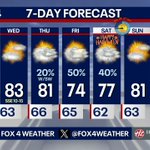
Most will be warm & dry Wednesday. A lead disturbance brings a few showers Thursday PM, mainly west of DFW. Rain chances increase Friday. A 2nd round of showers Saturday should depart by late afternoon. More showers/storms early next week, followed by a mid-week cooldown.
Scattered showers and storms Friday, then a second round of scattered showers Saturday. Right now, it appears most of the rain should move off to our northeast by late Saturday afternoon.
Morning clouds and an isolated shower are expected through the commute. This afternoon, expect decreasing clouds. We are in between disturbances for Wednesday. The strongest piece of energy arrives Friday into Saturday. We slowly dry out from west to east Saturday.
Clouds and low shower chances expected through the morning commute. A bit more sunshine on tap for your afternoon, as highs top out in the low 80s.
10:05pm: A batch of mainly light rain showers are impacting areas from Breckenridge northeast to Bowie and Nocona. Much of this will likely stay west and north of Fort Worth tonight.
A weak disturbance may bring a few spotty showers overnight into Tuesday AM, especially west and north of DFW. A couple stronger disturbances aided by an influx of Pacific moisture will bring better rain chances Friday and Saturday with highs in the 70s.
A quiet start to the week becomes more active heading toward the weekend. SW flow aloft sets up, bringing more clouds and weak disturbances. As of now, showers and storms will still be possible for Halloween, with drier conditions by Sunday.
More clouds stream in through the day. Expect highs near 80 for your Monday afternoon. Low rain chances return tonight into Tuesday. Better rain chances expected to end the week.
Dan Henry retweeted
7 DAY FORECAST: High clouds will be around much of the day on Monday, but we should see some sunshine peek through in spots during the afternoon. A few storms may be possible Tuesday to our west. Better storm chances arrive towards Halloween. Plan costumes accordingly.
Dan Henry retweeted
7 DAY FORECAST: Highs will stay in the 80s most of the week. We have some high clouds that will work in for Sunday and Monday providing "filtered" sunshine. The pattern looks to get more active to end the week, which could bring some rain chances in for Halloween! #TXwx


