

Meteorologist (CBM) 20+yrs TV, Baltimore, College Prof, weather geek,dad and outdoor lover. #FITF, Founder of The Maryland Trek, Just In Power Kids
Baltimore, MD
Joined January 2008
- Tweets38K
- Following1.3K
- Followers54.7K
- Likes18.4K






Pinned Tweet
Winner!
Crescent sunrise ☀️🌙🌎❤️
#PartialSolarEclipse
over Baltimore from my friend
Tim Shahan
#SolarEclipse

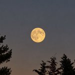
Full Moon AND Fall Foliage this morning.
@nurse_jackie13 pulled over on her way to work to capture this gem.

Good Morning it’s MONDAY OCTOBER 26
🧵1 of 2
🌥️ Patchy Fog
☀️ Another Sunny and Warm Day
🌵8 Days since the last rain AND the earliest I see anything may be Sunday
READ MORE 🔗 👉 Full Morning Report
justinweather.com/2026/10/26…


🧵2 of 2
👻🎃 Halloween Looks Warm and Dry
⏰ Clocks Change (back one hour) Sunday Morning
READ MORE 🔗 👉 Full Morning Report
justinweather.com/2026/10/26…


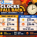
⏰🍁 ONE WEEK UNTIL WE FALL BACK!
Are you ready for sunsets closer to 5 PM? 🌇
At least the sun will be rising before 7 AM again… for a few weeks! 🌅
Next Sunday, November 1, Daylight Saving Time ends, and we return to Eastern Standard Time. At 2 AM, clocks move BACK one hour. That means an extra hour of sleep for many of us!
☀️ Here’s how sunrise and sunset change in Baltimore:
📅 TODAY – Sunday, October 25
🌅 Sunrise: 7:27 AM
🌇 Sunset: 6:14 PM
☀️ Daylight: 10 hours, 47 minutes
📅 NEXT SUNDAY – November 1
🌅 Sunrise: 6:34 AM
🌇 Sunset: 5:06 PM
☀️ Daylight: 10 hours, 32 minutes
📉 That’s a sunset 68 minutes earlier on the clock in just one week!
But here’s something worth pointing out…
⏰ We don’t actually lose an hour of daylight when we change the clocks. We’re simply shifting that hour from the evening to the morning.
☀️ The REAL loss of daylight is about 15 minutes over the week as we continue toward the Winter Solstice on December 21.
And while we’ll enjoy sunrises before 7 AM again, that won’t last long. The sun will continue rising later each morning as we head toward winter.
🏛️ WHAT ABOUT THE SUNSHINE PROTECTION ACT?
You may remember the proposal to stop changing our clocks twice a year.
The U.S. House of Representatives passed the Sunshine Protection Act in July by a vote of 308–117.
However, the Senate has STILL not voted on it.
If approved and signed into law, the bill would make Daylight Saving Time permanent, keeping sunsets an hour later during the winter months. The trade-off would be much darker winter mornings.
For now, we’re still changing our clocks!
🍂 NOW THE BIG QUESTION:
Would you rather have…
🌅 More daylight in the MORNING?
🌇 More daylight in the EVENING?
⏰ Or would you simply prefer to stop changing the clocks twice a year?
I’m curious where everyone stands on this!
#clockchange
#DaylightSavingTime
#daylightsavings
#standardtime

🍁 Eye Candy
Looks like York County will be at Peak Foliage this week.
Here’s today’s view at Lake Redman and Lake Williams.
📷 Jackie Diamond
#October
#fallfoliage
#Pennsylvania


Good Morning it’s SUNDAY OCTOBER 25
🧵1 of 2
⚠️🧊Frost AND Freeze In More Areas To Start The Day
🌥️ Patchy Fog
☀️🏈🐦⬛ Ravens Game Weather Looks GREAT!
READ MORE 🔗 👉 Full Morning Report
justinweather.com/2026/10/24…


🧵2 of 2
☁️ Fog Likely To Develop Again Overnight and Monday Morning
🌡️ Monday: A Little Warmer And A Few More Clouds
🌵No Rain In Sight Through Halloween!
READ MORE 🔗 👉 Full Morning Report
justinweather.com/2026/10/24…


☀️ NOTHING FOR ANOTHER WEEK!
👀 Looking Ahead To A Dry End To October!
🌵 No Rain In Sight Into Next Weekend! Although we may get more clouds at times...
📏💦 This will put us back into the 6 inch Annual Rainfall Deficit By Then.
🍁 This may be good for leaf peeping as we approach Peak Fall Foliage...
‼️It will ALSO get Mighty Crispy!
🔥 Fire Danger may be something to start considering.
Just want to put this out there as we enjoy this sunny Saturday.


Good Morning it’s SATURDAY OCTOBER 24
🧵1 of 2
⚠️🧊 Got Frost? More in NE MD and Delmarva have it today.
🌥️ Fog Has Been Developing And More Expected Sunday Morning
☀️↕️🌤️ Today Brings More Clouds On Our South Side
☁️ Fog Likely To Develop Again Overnight and Sunday Morning
🏈🐦⬛ Ravens Game Weather Looks GREAT!
READ MORE 🔗 👉 Full Morning Report
justinweather.com/2026/10/24…


🧵2 of 2
🌵No Rain In Sight Through Next Week!
READ MORE 🔗 👉 Full Morning Report
justinweather.com/2026/10/24…


⚠️ 🧊 Northern Delmarva has joined North Central Maryland in The Frost Advisory Club.
The light wind from the ocean will add moisture and help with the frost.
I’m looking forward to see how far down the peninsula this stretches.
Note: West of Lancaster the growing season is considered over after experiencing a Freeze.

👀 Looking Ahead:
🌡️ October ends warmer than average!
🌧️ How about some needed rain?
👉🏻 The Climate Prediction Center is supporting some of that Pacific Tropical/El Nino induced moisture pummeling the Southwest US will expand east.
💦 November may turn more active and wet.
Just dropping a nugget for you.


Good Morning it’s FRIDAY OCTOBER 23
🧵1 of 2
🌀 Josephine Now POST-Tropical, But Still Affecting Local Water Levels
⚠️🌊 Coastal Flood Advisory Includes Anne Arundel County
☀️ 🌡️ Cooler Today
READ MORE 🔗 👉 Full Morning Report
justinweather.com/2026/10/23…


🧵2 of 2
☁️ Fog May Develop Overnight and Morning
🧊 More Areas May Get Frost This Weekend
🎢 Another push of cool air for the Weekend and Warning Next Week.
READ MORE 🔗 👉 Full Morning Report
justinweather.com/2026/10/23…

🌀❄️ POLAR VORTEX WEAKENING: Pattern Change Begins In November AND THEN Support for My First Snowfall Call In Early December:
🤓 I Geeked Out A Little Here...
Something unusual is developing nearly 20 miles above the Arctic, and the latest European and American models are showing a significant disruption of the Polar Vortex in early November!
📉 THE CHANGE: The Polar Vortex should be strengthening this time of year. Instead, models show significant weakening around November 4–6.
⏳ THE DELAY: It can take 1–3 weeks or longer for a weakened Polar Vortex to influence the jet stream and potentially push colder air into eastern North America.
❄️ MY FIRST SNOW CALL: December 5, give or take 4–6 days. The timing of this disturbance offers possible support for that early-December window!
🌊 EL NIÑO: A potentially active southern storm track could add another ingredient, IF we get the cold air.
⚠️ NOT A GUARANTEE: A weaker Polar Vortex does not automatically mean cold or snow in Maryland.
📊 NEW FULL REPORT: I break down the latest model maps, what similar winters produced in Baltimore, and why this development has my attention.
🔗 Full Report: Polar Vortex Weakening Early justinweather.com/2026/10/22…
Faith in the Flakes! ❄️
#winter
#weatheroutlook
#polarvortex
#snow #FITF


🌱💧 DROUGHT MONITOR & LAWN HEALTH INDEX UPDATE | OCTOBER 22
Our lawns are holding up well as the growing season winds down, but the dry weather pattern and persistent rainfall deficit remain concerns.
🗺️ DROUGHT MONITOR: NO CHANGE
The latest map shows essentially no change across Maryland.
Abnormally Dry and Moderate Drought conditions remain across portions of our region.
Recent rainfall has helped our lawns, but the longer-term moisture deficit remains substantial.
📊 LAWN HEALTH INDEX: 67/100 — GOOD
⬇️ Down 1 point from last week.
🌱 WHY THE SMALL DROP?
Fall temperatures continue to favor Central Maryland’s cool-season grasses, including Tall Fescue and Kentucky Bluegrass.
We’ve already experienced the first frost of the season in some inland locations, although areas closer to the Chesapeake Bay have remained warmer.
But rainfall has become limited again, and there is NO SIGNIFICANT RAIN IN THE FORECAST!
💧 RAINFALL UPDATE AT BWI
• October: 2.61” — 0.12” BELOW average
• Since September 1: 5.86” — 1.31” BELOW average
• 2026: 31.96” — 4.99” BELOW average
• Since January 1, 2024: 21.90” BELOW average!
BWI received another 0.52” of rain since last week’s report. However, the annual deficit increased from 4.62” to 4.99” because rainfall did not keep pace with the normal accumulation.
☀️ WEATHER OUTLOOK: SUNNY • SEASONABLE • DRY
🌡️ Temperatures near seasonal averages, with most afternoons in the 60s.
☀️ Plenty of sunshine.
💧 No significant rainfall in sight.
The cooler temperatures are beneficial for established lawns, but continued dry weather may limit additional improvement.
🌱 LAWN DOCTOR TIP OF THE WEEK: PUT YOUR YARD TO BED!
As the growing season winds down, it’s time to prepare your lawn and equipment for winter.
✂️ Keep mowing while the grass is growing. Tall Fescue generally slows considerably as soil temperatures approach 50°F.
💧 Reduce watering. Cooler temperatures lower water demand, but newly seeded lawns may still need supplemental moisture during prolonged dry periods.
🚰 Disconnect garden hoses and properly winterize irrigation systems before freezing temperatures arrive.
🚜 Prepare your mower for winter. Clean the deck, follow the manufacturer’s fuel-storage recommendations, and store it in a properly ventilated garage or shed.
🍂 A little winter preparation now can save you headaches next spring!
🌱 THE BOTTOM LINE: Our lawns remain in GOOD condition thanks to the fall growing season, but the dry weather pattern and persistent rainfall deficit are keeping the Lawn Health Index from climbing higher.
🌱👍Presented by @LawnDoctor of Annapolis-Bowie
Serving All of Central Maryland
#drought
#DroughtMonitor
#lawncare
#autumn
#weather

Just putting this out there…
🌀 🌀 👀 These two cyclones LOOK very similar and in very similar locations at one point in their lifespan off the Mid Atlantic coast.
September we had the unnamed Nor’easter that retrograded/turned westward on to the NJ coast.
October we have Subtropical Storm Josephine named Wednesday and may become a hurricane.
This stayed farther off the coast and is tracking on a more classic Northeastern path.
✅ Yes, I believe we will have multiple Nor’easter’s this winter.
No two will be the same.
🤏Some will be on the coast
👋 Others may track just out of reach, and we can just wave as it passes by.
This will be the challenge all season for snow or rain or misses.
🏖️ 🌊 What I unfortunately do see is a repeating pattern that will batter the beaches with high waves and more erosion.
📝 I’m working on the signals of a pattern change for my report later today. But for now, enjoy the quiet weather. It will not stay this way indefinitely.
Cheers
Justin
#weather
#storm
#beaches
#noreaster
#subtropical
#atmosphermemory
#coastalstorm

This could be
Fun?
A good tool?
Or confusing if data is delayed?
I’d like to see it in action.
#migratingweatheralerts

It’s been in development a long time, but finally, “threats-in-motion” likely to come in 2028 as new software is implemented across the National Weather Service. Severe storm warnings will move with the storm. @nwas