

👔Meteorologist at @KSL5TV. 📚Utah Ute. 🏝California native.
Salt Lake City, UT
Joined November 2017
- Tweets8.7K
- Following386
- Followers5.6K
- Likes10.4K



Pinned Tweet
Textbook Kelvin-Helmholtz clouds cresting across the Wellsville Mountains of Utah! PERFECTION!🌊🤩#utwx
📍: Cache Valley, UT
📸: Holly Reynolds

(1/3)BREAKING: A rockslide near Bridal Veil Falls has closed Provo Canyon trail this afternoon! Last night’s heavy rain in Utah County likely contributed to this slide today. To our knowledge right now no one was hurt, but it was a close call for those in the area.
(2/3) Emerson Galland and Emerson Hamilton captured video of the actual slide and some of the aftermath! Portions of the Provo River Trail were significantly damaged along with some trees that were toppled over.

(1/2)Between about 6:45-9:00AM today, an estimated 2” fell on the headwaters of Gould Wash! That was enough to send a flood wave down the Wash and into the town of Hurricane.
MAJOR FLOODING: New video coming in from Hurricane, Utah shows just how intense the flooding has become this morning! Gould’s Wash has been running wild this morning, FOR A SECOND TIME THIS SEASON!
Flash flood warnings for Zion National Park and eastern Washington County. #utwx


(1/3)SEVERE THUNDERSTORMS: The latest model data this morning is suggesting a chance for strong to severe t-storms in southern Utah. The atmosphere is most primed for supporting supercell thunderstorms in the yellow, but the dark green is also an area where severe storms


(2/3) could form as well.
The primary threat today will be for flash flooding, large hail (1.00") and frequent lightning. We also need to be aware that the potential for a brief tornado is non-zero. What I mean is that there is a very low chance (2%) that a brief funnel cloud
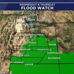
(1/2) SOUTHERN UTAH FLOOD WATCH: A late season surge of tropical moisture will bring widespread moderate to at times heavy rainfall across much of southern Utah beginning Wednesday morning, and continuing through Thursday.

WEDNESDAY - FRIDAY RAIN: Here’s the model average for rain totals OCT 21-23. Southern Utah will probably pick up the bigger totals, still a great soaking rain for Utah! #utwx

(1/2) CUT-OFF LOW: A new low pressure system is set to drop into California, by Wednesday we will see showers and t-storms start popping up across southern Utah. Northern Utah's best chances for rain are Thursday and Friday. Snow elevation right now looks like 7500'-8000'
