

Max Velocity is a degreed meteorologist who provides accurate, honest, and reliable weather forecasts and live streams across the USA.
United States
Joined January 2022
- Tweets17.3K
- Following189
- Followers182K
- Likes19K

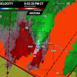


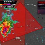


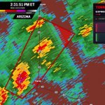

It looks like @ChasingWConnor had a huge tornado in Overgaard, Arizona, moments ago...
He's live here: youtube.com/watch?v=x_baBV02…

We are seeing reports of downed trees and roofing damage in Overgaard, Arizona. It's very likely we saw a tornado.

I'm pretty confident we have a strong tornado moving through Overgaard, Arizona, right now...
This will be moving into rural portions of Navajo County over the next few minutes as it tracks up to Arizona 377.

Possible tornado heading into Heber-Overgaard, Arizona, right now...
As of now, no tornado warning for this. I'd take shelter if you live here! @WxFront

We’re down to the LAST 4 names on the Eastern Pacific naming list with Tropical Storm Vance being named...
This is the first Pacific season to make it to the "V" name since 2018!


The nor’easter we've been tracking over the last few days officially has a name... Subtropical Storm Josephine has just formed off the Mid-Atlantic coast!
It’ll pull away from the U.S. over the next few days, but coastal flooding continues from the Outer Banks to the Chesapeake through tomorrow.


Pieces of Halley’s Comet are going to be falling from the sky tonight...
The Orionid meteor shower peaks overnight, and the best time to look is from moonset (around 3 or 4 AM) until dawn. If you’re in the green, you’ve got the best shot at clear skies.


Tropical Depression Twenty-Two-E just formed south of Mexico, and it’s forecast to quickly intensify into a Category 3 hurricane by Friday...
If that happens, it would be the 11th major hurricane of the season, TYING the East Pacific record set in 2015. The next name on the list is Vance.

A few tornadoes are possible in Arizona this afternoon and evening, especially north and east of Phoenix from Prescott to Flagstaff and Payson... with a brief one also possible along the Southern California coast.

Severe weather could impact central and northern Arizona today, bringing large hail, damaging winds and even a few tornadoes...
As a powerful storm system approaches from California, unusually humid air for the desert will surge north into Arizona. Storms should begin firing by early-to-mid afternoon north and east of Phoenix, from the Prescott area toward Flagstaff and Payson.
The threat will peak through the late afternoon as strong winds high overhead help these storms rotate into supercells. The strongest could produce hail bigger than golf balls, and a few brief tornadoes can’t be ruled out.
Heading into the evening, a second round of storms could move across north-central Arizona before the threat gradually winds down overnight. Heavy rain may also cause flash flooding in washes and burn scars, and a few waterspouts could move onto the Southern California coast.

Hurricane season is NOT done yet... there’s a chance something tries to form off Florida and the Bahamas right around Halloween, in addition to what's trying to develop off the East Coast currently.

Arizona is in an ENHANCED RISK for severe weather tomorrow... Flagstaff has NEVER been under a severe risk this high!!
Destructive hail (potentially exceeding 2" in diameter), and a few tornadoes will be possible. Arizona only averages about 5 tornadoes a year, so this could be a significant event for them!


