

Official X account for the National Weather Service Forecast Office Corpus Christi, TX. Details: https://teapawt.org/t.co/WW0Dxbcbfc
- Tweets43.1K
- Following209
- Followers29.8K
- Likes3.8K
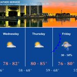







ALT National Weather Service Corpus Christi, TX five-day forecast graphic showing weather from Tuesday through Saturday, issued Monday, November 2, 2026, at 2:50 AM. The top features a panoramic photo of the illuminated Corpus Christi skyline and bay during a vivid orange sunset. Below are five forecast columns: Tuesday shows an 85% chance of thunderstorms accompanied by a cold front line, with highs of 81 to 87 degrees. Wednesday shows partly cloudy skies, highs 78 to 82, and lows 57 to 66. Thursday shows partly cloudy skies, highs 80 to 85, and lows 58 to 68. Friday shows another cold front line with a 30 to 50% chance of thunderstorms, highs 76 to 80, and lows 59 to 68. Saturday shows a 40% chance of thunderstorms, highs 73 to 77, and lows 57 to 66.

ALT Weather forecast map titled "Another Mild November Night" from the National Weather Service Corpus Christi, TX, issued November 2, 2026. Subtitle reads, "Lows in the 70s | Dry Conditions & Light Winds." The color-coded map displays South Texas shaded predominantly in pale yellow, indicating overnight low temperatures ranging from 70 to 75 degrees Fahrenheit. Specific forecasted lows include: 71° in Cotulla, Tilden, Beeville, Victoria, and Freer; 72° in Laredo and Alice; 74° in Port Lavaca; and 75° in Rockport and Downtown Corpus Christi. In the upper left corner, an icon shows a cloud passing over a full moon. Bottom bar shows a temperature scale ranging from 50°F to 80°F.

ALT A graphic of the Middle Texas Beach Forecast. Mostly sunny skies today will be accompanied by afternoon highs in the lower 80s. There is a LOW risk of rip currents. Please be cautious if entering the waters. If caught in a rip current, remember: Wave, Yell, Swim Parallel. UV Index is very high. Wave heights around 2 feet. High tide at Bob Hall Pier is 11:34 PM and for Port Aransas it's at 11:34 PM.

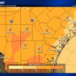
ALT Weather forecast map titled "90s In November" from the National Weather Service Corpus Christi, TX, issued November 2, 2026. A subtitle reads, "Mostly Dry Skies | Highs in the 80s to Around 90." The color-coded map illustrates projected high temperatures across South Texas, shading from yellow-beige for the lower 80s along the coast to deep orange for temperatures reaching 90 degrees inland. Forecasted high temperatures include: Cotulla 90°, Laredo 90°, Tilden 89°, Freer 89°, Alice 89°, Beeville 87°, Victoria 86°, Downtown Corpus Christi 84°, Rockport 83°, and Port Lavaca 81°. A partly cloudy icon showing a sun behind a cloud appears in the upper left over the western region.

ALT A National Weather Service Corpus Christi advisory graphic announces a Dense Fog Advisory in effect through 10 AM today. A map of South Texas highlights the advisory area covering the Inland Coastal Bend, specifically Nueces, Kleberg, Jim Wells, San Patricio, Refugio, Calhoun, Bee, Goliad, and Victoria counties. Hazards include visibilities dropping below one-quarter mile. Recommended safety actions list: slow down and increase following distance, turn on low-beam headlights, and consider delaying travel until conditions improve.

ALT National Weather Service Corpus Christi, TX five-day forecast graphic showing weather from Tuesday through Saturday, issued Monday, November 2, 2026, at 2:50 AM. The top features a panoramic photo of the illuminated Corpus Christi skyline and bay during a vivid orange sunset. Below are five forecast columns: Tuesday shows an 85% chance of thunderstorms accompanied by a cold front line, with highs of 81 to 87 degrees. Wednesday shows partly cloudy skies, highs 78 to 82, and lows 57 to 66. Thursday shows partly cloudy skies, highs 80 to 85, and lows 58 to 68. Friday shows another cold front line with a 30 to 50% chance of thunderstorms, highs 76 to 80, and lows 59 to 68. Saturday shows a 40% chance of thunderstorms, highs 73 to 77, and lows 57 to 66.

ALT Weather forecast map titled "Another Mild November Night" from the National Weather Service Corpus Christi, TX, issued November 2, 2026. Subtitle reads, "Lows in the 70s | Dry Conditions & Light Winds." The color-coded map displays South Texas shaded predominantly in pale yellow, indicating overnight low temperatures ranging from 70 to 75 degrees Fahrenheit. Specific forecasted lows include: 71° in Cotulla, Tilden, Beeville, Victoria, and Freer; 72° in Laredo and Alice; 74° in Port Lavaca; and 75° in Rockport and Downtown Corpus Christi. In the upper left corner, an icon shows a cloud passing over a full moon. Bottom bar shows a temperature scale ranging from 50°F to 80°F.

ALT A graphic of the Middle Texas Beach Forecast. Mostly sunny skies today will be accompanied by afternoon highs in the lower 80s. There is a LOW risk of rip currents. Please be cautious if entering the waters. If caught in a rip current, remember: Wave, Yell, Swim Parallel. UV Index is very high. Wave heights around 2 feet. High tide at Bob Hall Pier is 11:34 PM and for Port Aransas it's at 11:34 PM.

ALT Weather forecast map titled "90s In November" from the National Weather Service Corpus Christi, TX, issued November 2, 2026. A subtitle reads, "Mostly Dry Skies | Highs in the 80s to Around 90." The color-coded map illustrates projected high temperatures across South Texas, shading from yellow-beige for the lower 80s along the coast to deep orange for temperatures reaching 90 degrees inland. Forecasted high temperatures include: Cotulla 90°, Laredo 90°, Tilden 89°, Freer 89°, Alice 89°, Beeville 87°, Victoria 86°, Downtown Corpus Christi 84°, Rockport 83°, and Port Lavaca 81°. A partly cloudy icon showing a sun behind a cloud appears in the upper left over the western region.

ALT National Weather Service Corpus Christi, TX five-day forecast graphic against a backdrop of the Corpus Christi skyline at sunset, dated Sunday, November 1, 2026. Monday shows partly cloudy skies with highs from 83 to 90 degrees and lows from 69 to 75 degrees. Tuesday features a cold front symbol, a thunderstorm icon, and a 90 percent chance of rain, with highs of 81 to 87 degrees and lows dropping to 57 to 66 degrees. Wednesday through Friday show a return to partly cloudy skies following the front. Wednesday highs reach 75 to 82 degrees with lows of 56 to 66 degrees. Thursday highs reach 77 to 83 degrees with lows of 55 to 65 degrees. Friday brings a 15 percent chance of rain in the northeast with highs between 76 and 82 degrees.

ALT National Weather Service forecast map for South Texas, titled "A Pleasant Night Across South Texas: Dry Conditions with Light Winds," issued by the Corpus Christi, TX office on November 1, 2026, at 1:20 AM CDT. A color-coded regional map shows forecast low temperatures ranging from the upper 60s to mid-70s Fahrenheit, with an icon showing a cloud against a full moon in the upper-left corner. Specific forecast low temperatures across key cities include: Victoria at 68 degrees; Beeville, Freer, and Tilden at 69 degrees; Alice and Cotulla at 70 degrees; Laredo and Port Lavaca at 72 degrees; and Rockport and Downtown Corpus Christi at 74 degrees. The color scale at the bottom ranges from green for cooler temperatures near 60 degrees to pale yellow and tan for temperatures approaching 75 to 80 degrees.

ALT A graphic of the Middle Texas Beach Forecast. Mostly sunny skies today will be accompanied by afternoon highs around 80 degrees. There is a MODERATE risk of rip currents. Please be very cautious if entering the waters. If caught in a rip current, remember: Wave, Yell, Swim Parallel. UV Index is very high. Wave heights around 2 feet. High tide at Bob Hall Pier is 11:26 PM and for Port Aransas it's at 11:14 PM.

ALT Weather forecast map from the National Weather Service in Corpus Christi, Texas, titled "November Kicks Off on a Warm Note: Highs in the 80s | Dry Skies & Light Winds," issued November 1, 2026. The map displays South Texas shaded in shades of yellow and orange, indicating forecast high temperatures mostly in the mid to upper 80s. Specific forecast highs include: Laredo at 88 degrees; Alice, Freer, and Tilden at 87 degrees; Beeville and Cotulla at 86 degrees; Victoria at 84 degrees; Rockport at 83 degrees; Downtown Corpus Christi at 82 degrees; and Port Lavaca at 77 degrees. A partly cloudy sun icon sits in the upper left corner over western areas, indicating dry and partly cloudy conditions throughout the region.

ALT Dry conditions prevail for much of the period. A medium to high chance of showers and thunderstorms Tuesday as a cold front is generally expected. Highs will generally be in the 80s much of the week with around 90 degrees Monday. Lows in the 60s to mid 70s give way to the 50s and 60s after the cold front.

ALT Weather forecast map from the National Weather Service Corpus Christi, TX, titled "No Tricks, Just Treats in Tonight's Forecast." A subheader notes that trick-or-treating conditions will be dry with light winds and temperatures in the low to mid-70s, with the map displaying overnight lows. A Halloween graphic in the upper left features a full moon, flying bats, and a glowing jack-o'-lantern. Forecasted low temperatures across South Texas include: Victoria 67 degrees, Beeville 67 degrees, Tilden 68 degrees, Freer 68 degrees, Cotulla 69 degrees, Alice 69 degrees, Port Lavaca 70 degrees, Laredo 71 degrees, Rockport 71 degrees, and Downtown Corpus Christi 72 degrees.

ALT A graphic of the Middle Texas Beach Forecast. Mostly sunny skies today will be accompanied by afternoon highs around 80 degrees. There is a MODERATE risk of rip currents. Please be very cautious if entering the waters. If caught in a rip current, remember: Wave, Yell, Swim Parallel. UV Index is very high. Wave heights 2-3 feet. High tide at Bob Hall Pier is 11:57 PM and for Port Aransas it's at 11:39 PM.

ALT National Weather Service Corpus Christi forecast map titled "Spooktacular Weather for Halloween Day," highlighting dry conditions with light and variable winds. A Halloween graphic in the upper left shows a witch's hat, magic wand, and sparkles beside a sun partly covered by a cloud. A regional map displays forecasted daytime high temperatures across South Texas: Port Lavaca at 79 degrees; Victoria, Rockport, and Downtown Corpus Christi at 81 degrees; Cotulla and Beeville at 82 degrees; Tilden at 83 degrees; Freer at 84 degrees; and Alice and Laredo reaching 86 degrees.

ALT Weather alert from the National Weather Service Corpus Christi titled "Coastal Flood Advisory" in effect through Sunday morning. A map of South Texas highlights the barrier island coastlines in lime green as the advisory area, extending past Corpus Christi and Rockport toward Port Lavaca. Key details include high tides this evening occurring at 11:57 PM for Bob Hall Pier and 11:39 PM for Port Aransas. Impacts along the barrier islands include high tides around 2 feet above mean sea level (or 1 foot inundation), with beach erosion and flooding of lots and parks possible. Graphic updated October 31, 2026.

ALT Este gráfico muestra la localización en el mapa de un Aviso Especial Marítimo. El aviso estará en efecto hasta las 3:00 PM CDT. El aviso incluye a Aguas Costeras desde el Puerto Aransas hasta el Canal de Matagorda hasta 20 MN. Las amenazas asociadas a este aviso son: ráfagas de vientos de mayor de 34 nudos yno se espera granizo. Las trombas marinas son posibles. Alto oleaje. Busque un puerto seguro y tome medidas de precaución.

ALT This graphic displays a special marine warning plotted on a map. The warning is in effect until 3:00 PM CDT. The warning includes coastal waters from Port Aransas to Matagorda Ship Channel out 20 NM, San Antonio, Mesquite and and Espiritu Santo Bays. The threats associated with this warning are wind gusts greater than 34kts and no hail expected.Waterspouts are possible. Steep waves can be expected. Seek safe harbor and take protective actions.