

Official X account for the National Weather Service in Milwaukee. Details: https://xitter.cf/t.co/s5GKP27ozy
- Tweets34.1K
- Following372
- Followers37.6K
- Likes11K
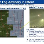







ALT A map depicts Fond du Lac, Sheboygan, Washington, Dodge, Ozaukee, Waukesha, Milwaukee, Racine, Kenosha and Walworth Counties in a Dense Fog Advisory until 10 AM CDT today.

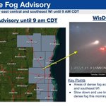
ALT A map depicts Washington, Ozaukee, Waukesha, Milwaukee, and Racine counties in a Dense Fog Advisory until 10 AM CDT Friday. The epicenter of the fog is depicted in south-central Milwaukee county, with a transportation-department camera depicting poor visibility on Interstate 94.

ALT A graphic depicts a satellite fog algorithm, mapped across southeastern Wisconsin. The map shows a mix of fog and low stratus clouds pushing southwest into eastern WI off of Lake Michigan.


ALT Image on the left is of the Dense Fog Advisory and the image on the right shows a WisDOT camera from Fond du Lac County.

ALT Image on the left is of the Dense Fog Advisory and the image on the right shows a WisDOT camera from I-41 at Lannon Road.

ALT Image on the left is of the Dense Fog Advisory and the image on the right shows a WisDOT camera from I-41 at Lannon Road.

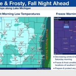
ALT The image on the left is an image of the forecast low temperatures tonight while the image on the right is of the Freeze Warning and Frost Advisory.

ALT The image on the left is an image of the forecast low temperatures tonight while the image on the right is of the Freeze Warning and Frost Advisory.

ALT Three hourly tables of temperatures and winds gusts for southern WI

ALT Friday night to Saturday morning low temps in the upper 20s to lower 30s. Freeze Watch for inland areas of southern WI.

ALT Hourly precipitation chances table highlighting the increase chances this evening and lull overnight and increasing again for Friday morning.

ALT Graphicast explaining the widespread rain chances across southern Wisconsin today. Text boxes explaining latest forecast thinking are shown on the left, with a map of expected rainfall totals shown on the right hand side of the graphic.

ALT Graphicast explaining gusty wind potential on Friday. Key forecast points are shown on the left, with an hourly forecast table of wind gusts around southern Wisconsin shown on the right.

ALT Graphic showing a table of rain probability and timing. The best window for rain is shown to be from 2pm to 11pm tomorrow. Highs will be in the mid to upper 50s.


ALT This graphic displays a special weather statement plotted on a map. The statement is in effect until 8:30 PM CDT. The statement includes Monroe WI, Brodhead WI and Albany WI. A STRONG THUNDERSTORM WILL IMPACT SOUTHERN GREEN COUNTY THROUGH 830 PM CDT. The threats associated with this storm are wind gusts up to 30 MPH and half inch sized hail. Seek shelter in a sturdy structure until the storm passes.

ALT This graphic displays a special weather statement plotted on a map. The statement is in effect until 8:00 PM CDT. The statement includes Darlington WI, Argyle WI and South Wayne WI. A STRONG THUNDERSTORM WILL IMPACT CENTRAL LAFAYETTE COUNTY THROUGH 800 PM CDT. The threats associated with this storm are wind gusts up to 30 MPH and half inch sized hail. Seek shelter in a sturdy structure until the storm passes.

ALT This graphic displays a special weather statement plotted on a map. The statement is in effect until 7:30 PM CDT. The statement includes Oregon WI, Belleville WI and New Glarus WI. A STRONG THUNDERSTORM WILL IMPACT NORTHERN GREEN AND SOUTHWESTERN DANE COUNTIES THROUGH 730 PM CDT. The threats associated with this storm are wind gusts up to 30 MPH and half inch sized hail. Seek shelter in a sturdy structure until the storm passes.

ALT This graphic displays a special weather statement plotted on a map. The statement is in effect until 7:00 PM CDT. The statement includes Mineral Point WI, Blanchardville WI and Hollandale WI. A STRONG THUNDERSTORM WILL IMPACT NORTHEASTERN LAFAYETTE AND SOUTHEASTERN IOWA COUNTIES THROUGH 700 PM CDT. The threats associated with this storm are wind gusts up to 30 MPH and half inch sized hail. Seek shelter in a sturdy structure until the storm passes.
