

Official Twitter account for the National Weather Service Norman, OK. Details: https://xitter.cf/t.co/7wu0v9PuGF
Norman, OK
Joined May 2011
- Tweets59.3K
- Following1.1K
- Followers135K
- Likes16.4K

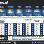


We hit at least 80 degrees at each of Oklahoma City, Lawton, and Wichita Falls today. That puts us at 11 out of 21 days at 80+ so far this October in OKC. The long-term average is 10 days of 80+ weather, but we generally have beaten that in recent years.
So far, the high in OKC is 80 F...but on this date in 1978, the temperature warmed to 90 degrees in Oklahoma City, which became a record high temperature for October 21. In 2004, this record was tied.
Rain chances will increase later this weekend into early next week. Impactful rainfall is not likely with this activity. Most locations may see up to an inch through Monday.

ALT This graphic depicts the forecast rain chances this weekend into early next week.

4:30 AM - Scattered showers continue across northern Oklahoma this morning. New rainfall amounts will remain quite light, less than 0.1 inch for most.
Activity is expected to gradually diminish across north-central Oklahoma after sunrise.
#okwx
Scattered rain showers continue across northern Oklahoma as we roll on into Wednesday.
Outside of the potential for a few lightning strikes, minimal impact or new rainfall accumulation is expected early this morning.
#okwx
You probably saw some "jellyfish clouds" with wispy rain shafts under them today. That's because we have a deep moist layer between about 10,000 and 20,000 feet above us (purple oval).
The very dry layer (brown oval) right below it caused the rain to mostly evaporate.

Love the photo. Cool rainbow, very scenic foreground.
You can see one of the elevated showers we've had this afternoon causing the rainbow with the wispy streaks of rain falling out of the cloud above. Because of dry air, little of this rain is reaching the ground.


Big rises at Hefner, Overholser, and Arcadia from the recent rains. Not too bad for Altus-Lugert and Fort Cobb, either!

How much did lake levels change from Oct. 13 to Oct. 19 after those big rains? Central OK lakes rose 5-6 feet in some cases. Some lakes in southeast Oklahoma even dropped during that period! (h/t to OWRB for the data). #okwx #okmesonet

4 PM - Showers and a few thunderstorms are ongoing west of I-35 this afternoon. Lightning will be the main concern with this activity.
230 PM - Showers and a few storms are ongoing west of I-35 this afternoon. The main concern with this activity will be lightning.


The warming trend continues today with afternoon highs expected to be a few degrees warmer than yesterday. These highs will be close to normal for this time of year. Partly cloudy skies and south to southeast winds are also expected today. Have a good Monday! #okwx #txwx

ALT Graphic shows forecast conditions for Monday.

