

Preparing our community for emergencies, equipping first responder agencies with necessary tools and supporting public safety initiatives.
Santa Barbara County
Joined January 2018
- Tweets1.2K
- Following2.6K
- Followers902
- Likes302



Pinned Tweet
Click on the photo and hit the Follow button for all #SantaBarbaraCounty emergency alerts + updates when they happen
#SantaBarbara #Goleta #Lompoc #Montecito #SantaYnez
xitter.cf/i/lists/11848952860841…
One805 retweeted

Montecito is under mandatory evacuation. We are on higher ground so they asked us to shelter in place. Please stay safe everyone.
The board, the Advisory council and the friends of one805.org send our condolences and prayers to the Royal family and the British public . RIP HRH Queen Elizabeth II, you will always be remembered for your extraordinary leadership, humility and joy for life.

The board, the Advisory council and the friends of one805.org send our condolences and prayers to the Royal family and the British public . RIP HRH Queen Elizabeth II, you will always be remembered for your extraordinary leadership, humility and joy for life.
One805 retweeted
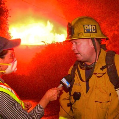
#BridgeFire- UPDATE- Per IC Cathedral Oaks/Foothill Rd, surface streets open. Highway 154 will remain closed (in the area) due to firefighting equipment on highway & mop up operations until midnight.


One805 retweeted
VegetationFire- #BridgeFire FF’s on scene of a fire burning off Via Gaitero near Hwy 154/Cathedral Oaks. IC reporting wind pushed fire 1/2 acre burning downhill in grass with potential for 10 acres. Resources still arriving on scene. C/T 6:53 p.m.
One805 retweeted

#HollisterFire not currently causing elevated #airquality readings in #SantaBarbaraCounty. Conditions are dynamic & can change quickly; check EPA Fire & Smoke map regularly (link in bio) & take precautions if you smell smoke. Thanks to the firefighters working on this incident!

One805 retweeted

New Incident: #HollisterFire off Hollister Ranch Road and Del Norte Road, southwest of Solvang in Santa Barbra County is 40 acres.
fire.ca.gov/incidents/2022/3…


One805 retweeted

Santa Barbara County Sheriff's Office confirmed that at least 30 homes have been evacuated due to the #HollisterFire ksby.com/news/local-news/gav…

Check out sbcfire.com/permit-burning for locations today. There is an active burn in the carpinteria hills today. – at Santa Barbara, CA


Thank you @montecitofire Footage from a reporting crew with experience helps us inform while hoping others do not put themselves in harms way.

Thank you @mimi_elder for your great info

#California #Coast #MultipleCounties #USA #Tsunami #Advisory #InProgress #Now
“⚠️Move off the beach/boats and away from harbors and marinas.
⚠️First wave may not be the largest”.
FEMA app and @NWS_NTWC have specific areas, approximate times delineated⤵️

One805 retweeted

A visual reminder that tsunamis are *not* like a single big ocean wave: they are a series of successive surges of water that may be only a few feet in height yet still contain a massive amount of energy and can affect bays and inlets otherwise protected from ocean waves. #tsunami


One805 retweeted
The plot shows water level data from Honolulu, Hawaii.
It indicates that the tsunami continues to impact the Hawaiian islands at least 7 hours after initial arrival.
Expect a similar, long duration event along our coast and bays today.

One805 retweeted

Seeing some surges on the Port San Luis tsunami gauge. Reporting up to a 24 cm residual so far. That's 9.4 inches or about 19 inches from the bottom and top of the residual. More at tidesandcurrents.noaa.gov. #tsunami

Check out this 2012 SB Tsunami video from our friend Marco Farrell who is always around to help us with information ! This video can give you context of what the impact on our coastline could look like.
youtu.be/XsylB38c91Q