

Accurate, local weather without the mainstream hype! Proudly serving Bedford, Coffee, Franklin, Grundy, Marshall, Maury, and Moore Counties in Southern TN!
Southern Middle Tennessee
Joined October 2016
- Tweets24.5K
- Following1.1K
- Followers2.4K
- Likes26.1K




QUIET WEATHER THIS WEEK, BUT WATCHING NEXT WEEK CLOSELY! Proudly Sponsored by Adams Roofing! (adamsroofingtn.com)
1
117
🥶 FROM FREEZING TO THE 60s!
Why do temperatures swing 30–40 degrees in a single day?
☀️ Sunshine & cloud cover
💧 Atmospheric moisture
🌡️ Local terrain & temperature inversions
Monday's Weather Blog: stnweather.com/blog/freezing…
Heritage South CCU | #tnwx

5
269
Happy chilly Monday, everyone! The past few mornings have brought plenty of frost across Southern Middle Tennessee, especially Sunday morning and again this morning. Clear skies and temperatures dropping into the mid 20s for many of us have certainly helped things look a little wintry!
We’ll gradually warm up as the week goes on, so hopefully you won’t have to watch your neighbor run outside half-naked to start the vehicle for much longer! Tonight will bring another chilly one, with lows in the upper 20s and lower 30s areawide. By Wednesday morning, some communities should stay above freezing, although a little frost will still be possible. By Thursday morning, lows in the upper 30s and lower 40s should put even patchy frost out of the picture.
Our first hard freeze is finally behind us, which should help wrap up ragweed season and reduce some of those unwanted pests. Unfortunately, a freeze doesn’t get rid of every bug for the winter!
Other than warming temperatures, there isn’t much happening in the weather department. I’m still watching a slim chance for rain along a cold front around Sunday, but I’m not overly impressed at this point. Stay tuned for updates as we get closer!
______________
🏠 ADAMS ROOFING 🏠
This weather update is proudly sponsored by Adams Roofing, the official roofing company of Southern Tennessee Weather!
For more than 40 years, Adams Roofing has helped protect homes and businesses across Middle Tennessee with quality roofing, honest service, and expert craftsmanship.
Family-owned and operated, Adams Roofing is a GAF Master Elite® Contractor and certified in Duro-Last commercial roofing systems, providing trusted residential and commercial roofing services.
Whether you need a roof inspection after severe weather, repairs, or a complete roof replacement, Adams Roofing is ready to help.
📍 303 Deery St., Shelbyville
📞 (931) 684-1463
🌐 adamsroofingtn.com


3
210
We have a new beaver friend on our Deason Camera! This is about as close as I want to be to the Joe B Jackson exit today, but it's pretty neat we can see the new Murfreesboro Buc-ee's from our camera on Ransom Hill!

5
324
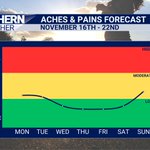
🦴 ACHES & PAINS FORECAST | NOVEMBER 16TH – 22ND
Presented by Lamb Counseling Services
A PRETTY QUIET WEEK IN THE ACHES & PAINS DEPARTMENT IS AHEAD! Despite a relatively mundane weather pattern across Southern Middle Tennessee this week, there are still a few things worth discussing when it comes to our aches and pains forecast.
We're starting Monday and Tuesday in the lower end of the YELLOW or "MODERATE PAIN" category. While no major storm systems are expected, we will be dealing with some rather large temperature swings! Temperatures will start near or below freezing each morning before climbing into the lower to middle 60s during the afternoon. These temperature swings of 30–35 degrees may contribute to increased joint stiffness, arthritis discomfort, and migraines for some weather-sensitive individuals.
By Wednesday, we'll transition into the GREEN or "LOW PAIN" category as a more stable weather pattern takes hold. High pressure and upper-level ridging will dominate our weather through much of the latter half of the workweek, keeping significant barometric pressure fluctuations and other major weather changes to a minimum.
Heading into the upcoming weekend, I'm watching the potential for our next cold front to approach the region by Sunday. While there are still plenty of question marks surrounding this system, I've increased pain levels back into the YELLOW category Sunday to account for the possibility of increasing weather changes and barometric pressure fluctuations. Overall, not too bad of a week in the aches and pains department!
🧡 LAMB COUNSELING SERVICES: Take advantage of the quieter moments in life to rest, recharge, and prepare yourself for whatever comes next.
📖 "Come unto me, all ye that labour and are heavy laden, and I will give you rest." (Matthew 11:28)
Hope Through Healing!
🌐 lambcounseling.net/
📞 (931) 492-6889

1
4
176
SOUTHERN MIDDLE TENNESSEE 7-DAY FORECAST: A rather mundane week in the weather department is ahead! Mostly sunny to partly cloudy skies can be expected each day, with afternoon highs gradually climbing from the low 60s early this week into the upper 60s and lower 70s by Friday and Saturday.
Overnight lows below freezing are expected tonight, Monday night, and Tuesday night, with additional rounds of heavy frost and patchy fog possible each morning. Afternoon temperatures will run above average for much of the week, especially as we approach the weekend. For perspective, our normal highs for this time of year are around 60 degrees, with normal lows near 35 degrees.
Our next cold front looks to push through the region by next Sunday, bringing slightly cooler temperatures. However, rainfall chances associated with this front look fairly slim at this point.
Beyond Sunday, things start getting a little more interesting as the weather pattern looks to become increasingly active heading into Thanksgiving week. We'll be keeping a close eye on how things evolve over the coming days, especially with holiday travel right around the corner!
____________________________
🪳 COOK'S PEST CONTROL 🐜
This forecast update is proudly sponsored by Cook's Pest Control, the South's most trusted name in pest control since 1928.
Now that we've experienced our first hard freeze of the season, don't be surprised if a few unwanted guests start looking for warmer places to spend the winter! Colder weather can drive pests indoors in search of warmth, food, and shelter. Keep your home protected year-round with dependable, local service from the experts at Cook's Pest Control.
🌐 cookspest.com
📞 (931) 684-5941


FROST FLOWERS in Unionville this morning!
Frost flowers form when air temperatures fall below freezing while the ground remains unfrozen. Moisture within certain plant stems is forced through tiny cracks and freezes, creating delicate, flower-like ribbons of ice. They typically melt shortly after sunrise.
Our official low at the Shelbyville Airport this morning was a chilly 23° at 6 AM!
📸 Photo credits: Kristin Leisman


11
482
WHEN WILL IT RAIN AGAIN? 🌧️ It's a question I get time and time again when I'm out and about, and it's a great one! So, let's dive a little deeper into some of the forecast data I look at when trying to pinpoint our next opportunity for rainfall across Southern Middle Tennessee.
First things first, I can confidently say that we're looking at little to no rainfall through at least next Saturday (November 21st). Dry as a bone! However, once we get beyond that point, things start getting a little more interesting.
One of my favorite pieces of long-range forecast guidance is the European model ensemble. An ensemble is essentially a collection of model simulations that start with slightly different atmospheric conditions. Since we can't perfectly measure the current state of the atmosphere, running these different simulations allows us to explore a variety of possible weather outcomes and better understand our forecast confidence.
I particularly like looking at what we call total precipitation plumes, which is what you're seeing in the graphic below. You may need to click on the image to see it more clearly, but here's how to interpret it:
• Each GRAY line represents an individual ensemble member, or one possible forecast scenario.
• The GREEN line represents the ensemble mean, which is the average of the ensemble members.
• The BLUE line represents the control forecast, which starts with the original, unaltered estimate of atmospheric conditions and provides another individual forecast scenario.
Since this graph displays accumulated rainfall, any upward movement in a line indicates additional rainfall, while a flat line indicates dry weather. The steeper the climb, the more rainfall is accumulating over a given period.
Notice how nearly all of the lines remain flat through next Saturday? That's why I have such high confidence in our extended stretch of dry weather. However, many of those lines, including the ensemble mean and control forecast, begin climbing around next Sunday and Monday (November 22nd and 23rd). That's a pretty encouraging signal that our next potential rainmaker could arrive during that timeframe! Unfortunately, most ensemble members are showing less than an inch of rainfall with this initial system, so it may not be much to write home about.
Beyond that, things get a little messier. You'll notice the gray lines begin climbing at different times and at different rates. This tells me that while there isn't much agreement on the exact timing or magnitude of additional storm systems, there's an encouraging signal for more opportunities for rainfall as we approach the end of November. It's certainly good to see those lines continuing to climb toward the end of the graph!
So, with all of that being said, rain chances look to begin increasing by next Sunday, with the potential for a more active and wetter weather pattern as we head through Thanksgiving week and toward the end of the month. Exact timing and rainfall totals will become clearer over the coming days, but it's certainly an encouraging trend worth watching!
Thankfully, you don't have to sit around analyzing graphs like this every day. That's my job! 😂 The purpose of this post is to give you a little behind-the-scenes look at how I put together a weather forecast and why forecast confidence can vary depending on the weather pattern. I'll continue to analyze and interpret this data for you, communicating what we know with confidence, what we're still uncertain about, and what you can realistically expect across Southern Middle Tennessee!
______________________
💡 RED WHITE & GLOW 💡
This evening's weather update is proudly sponsored by Red White & Glow, your local destination for custom vehicle lighting and aftermarket accessory installation in Manchester, Tennessee!
🚗 Make your ride SHINE! Whether you're looking to turn heads on the road or light up the trails, Red White & Glow has you covered! From eye-catching underglow, rock lights, and wheel lights to upgraded headlights, fog lights, LED light bars, safety lighting, and custom accessory wiring, they can bring your vision to life!
Proudly serving Middle Tennessee, Red White & Glow specializes in transforming cars, trucks, Jeeps, SUVs, and off-road vehicles with professional installations and custom lighting solutions!
Red White & Glow — Your Ride. Your Style. Your Glow.
📍 Manchester, Tennessee
📞 Call: (650) 955-0320
📲 Text: (931) 588-1099
🌐 redwhiteglowlighting.com


260
🥶 IT WAS A LITTLE CHILLY THIS MORNING! Temperatures dropped into the lower to middle 30s across Southern Middle Tennessee, a few degrees warmer than originally forecast. We can thank some stubborn cloud cover that hung around a little too late into the night for that! Clouds act like a blanket, slowing the loss of heat from the surface overnight. While a few locations still managed to dip below freezing, we didn’t quite see the widespread hard freeze we were expecting.
Thankfully, we won’t have that cloud cover issue tonight! Mostly sunny skies are expected throughout Saturday, allowing afternoon temperatures to climb into the lower to middle 50s. However, once the sun goes down, temperatures will drop rather quickly thanks to clear skies and light winds. By early Sunday morning, we’re expecting lows in the middle 20s across much of Southern Middle Tennessee, bringing a widespread HARD FREEZE and heavy, killing frost!
This will likely be our coldest night of the fall season so far, so make sure to protect sensitive plants, outdoor plumbing, and pets before heading to bed tonight. If you managed to escape the 20s this morning, you probably won’t be quite as lucky tomorrow morning! 🥶
__________________
🔧 ROSCOE BROWN PLUMBING 🔧
Today’s weather update is proudly sponsored by Roscoe Brown Plumbing, serving Middle Tennessee families since 1940!
💧 Don’t let plumbing problems rain on your parade! Whether you’re dealing with a clogged drain, leaking pipe, water heater issue, or an unexpected plumbing emergency, Roscoe Brown’s experienced team is ready to help. From drain cleaning and water heater installation to whole-home plumbing repairs and maintenance, they’ve got you covered.
For more than 85 years, Roscoe Brown has remained a third-generation family business built on trust, hard work, and treating customers like neighbors.
📍 Nashville | Murfreesboro | Tullahoma | McMinnville
📞 (615) 203-3874
🌐 RoscoeBrown.com


6
299
COLD WEATHER THIS WEEKEND! proudly sponsored by Clearwater Pool & Spa in Manchester! (931-728-6414)
5
206
🥶 WEEKEND OUTLOOK: HARD FREEZE AHEAD!
Some of the COLDEST temperatures of the fall arrive this weekend!
❄️ Lows in the 20s
☀️ Sunshine returns
🌡️ Gradual warmup next week
Friday's FULL blog: stnweather.com/blog/weekend-…
Heritage South CCU | #tnwx

5
277

🥶 THE CHILLY AIR HAS ARRIVED, AND IT'S HERE TO STAY FOR A FEW DAYS! Our much cooler air mass will definitely make its presence known across Southern Middle Tennessee on this Friday, with temperatures starting off in the lower 30s. By this afternoon, highs will struggle to get out of the 40s for most of us! We're looking at highs in the upper 30s along the Cumberland Plateau, with lower to middle 40s elsewhere. For perspective, our average high for November 13th is around 62 degrees, meaning we'll be running nearly 20 degrees BELOW average!
Partly to mostly cloudy skies are expected throughout the afternoon, and just how warm we get will depend heavily on how much sunshine breaks through. A little more sun could push temperatures a few degrees higher than forecast, but either way, it's going to feel CHILLY with a brisk northwest wind! Those near / along the Cumberland Plateau may struggle to see feels-like temperatures climb out of the mid 30s all afternoon.
We could also see a few VERY light rain showers this afternoon and evening, especially east of Interstate 65. These will be few and far between, with little to no measurable rainfall expected. However, there's a small chance that a few SNOWFLAKES could mix in across the higher elevations of Grundy County, including Monteagle and Sewanee in Franklin County! ❄️ Chances remain pretty slim, and I'm not expecting any accumulation or travel impacts.
The BIGGER story beyond today will be the COLD mornings ahead! Afternoon highs this weekend and into early next week will generally remain in the 50s, while overnight lows drop into the middle and upper 20s for several consecutive nights. That means our first HARD FREEZE of the season is likely, with several opportunities for a killing freeze over the next five mornings! A hard freeze generally occurs when temperatures reach 28 degrees or colder for an extended period, which can kill most remaining seasonal vegetation. I've included a graphic below showing our forecast morning lows, with each temperature listed above the day it corresponds to.
It's officially time to dust off those heavy jackets and ice scrapers! And I know I sound like a broken record, but PLEASE remember the THREE Ps as we head into this first significant freeze of the season: People, Pipes, and Pets! Check on elderly neighbors and anyone who may need help staying warm, make sure exposed outdoor plumbing and water hoses are protected, and bring outdoor pets inside where they can stay warm and sheltered from the cold. Winter may not officially be here just yet, but Mother Nature is certainly giving us a little preview of what's to come! 🥶
______________________
🛟 PROTECT YOUR POOL & SAVE $150 WITH CLEARWATER POOL & SPA!
With our first HARD FREEZE of the season arriving, NOW is the time to make sure your pool is protected from the cold! For a LIMITED TIME, our friends at Clearwater Pool & Spa are offering $150 OFF pool safety covers! Protect your investment, enjoy peace of mind, and save while you're at it! HURRY! This offer ends November 18th!
📞 Call Clearwater Pool & Spa at 931-728-6414 or visit them in-store to take advantage of this special offer!
📍 Clearwater Pool & Spa | 857 McArthur Street, Manchester, TN
Your Pool. Your Spa. Your People.


1
9
490
🌧️ FINALLY, A LITTLE DROUGHT RELIEF!
The latest Drought Monitor shows improvement across Southern Middle Tennessee!
🥶 PLUS: Our first HARD FREEZE, possible snow flurries, and the forecast ahead.
📱 Thursday’s FULL blog: stnweather.com/blog/finally-…
Heritage South CCU | #tnwx

4
218
THE COLD FRONT HAS CLEARED, AND NOW THE REAL COOLDOWN BEGINS! 🥶❄️ We're now in somewhat of a weird "transition zone" across Southern Middle Tennessee as cooler air slowly begins filtering into the region. We've still got a few minor weather changes to get through over the next 24–36 hours before our coldest temperatures of the fall season arrive this weekend!
Today will feature a mix of sun and clouds, with afternoon highs approaching the upper 50s. After lunchtime, we could see a few scattered light showers and areas of drizzle develop as the upper-level trough associated with our departing cold front swings through the region. However, widespread rainfall is NOT anticipated, and many communities may not see much of anything. A few light showers or patches of drizzle could linger into Thursday evening before coming to an end around midnight. By Friday morning, temperatures will have fallen into the upper 20s and lower 30s across Southern Middle Tennessee, making for a rather chilly start to the day!
We'll see another mix of sun and clouds throughout much of Friday, although there's one little wrinkle in the forecast that I'm keeping an eye on. The latest HRRR short-range forecast model is trying to bring an additional piece of weak atmospheric energy across our region Friday evening. If this materializes, we could see a few scattered light showers develop across our eastern communities, with some of that precipitation potentially falling as LIGHT SNOW across the higher elevations of the Cumberland Plateau, generally above 1,500 feet. The best chance for a few flakes would be in Grundy County and around Sewanee in Franklin County. Now, before anyone gets too excited, we're NOT expecting any snow accumulations or travel impacts, and there's still some uncertainty as to whether we'll see any precipitation at all. Believe it or not, around this same time last year, we were dealing with our first light snow event along the Cumberland Plateau! So, while it may seem a little early to be talking about snowflakes, it's really not all that unusual for the higher elevations to see a few flakes flying this time of year.
Once we get past that small chance for precipitation Friday evening, skies will begin clearing out, setting the stage for our coldest temperatures so far this fall. Overnight lows are expected to drop into the MID TO UPPER 20s Friday night, Saturday night, and potentially Sunday night as well! We're talking about our first widespread HARD FREEZE of the season, accompanied by a heavy, killing frost that will likely put an end to the growing season across much of Southern Middle Tennessee. If you've got outdoor plans after sunset or around sunrise Saturday and Sunday, you'll definitely want to break out the winter coat!
____________________________
🔥 REDD’S HEATING & AIR CONDITIONING
This weather update is proudly sponsored by Redd’s Heating & Air Conditioning — the official heating and air conditioning company of Southern Tennessee Weather!
For more than 50 years, Redd’s has proudly served our community as a family-owned and operated business. Whether you need repairs, routine maintenance, or a brand-new HVAC system, their experienced team is ready to help keep your home comfortable through Tennessee’s coldest days. Plus, they offer 24/7 emergency service when you need them most.
📍 704 Blue Ribbon Pkwy, Shelbyville
📞 (931) 684-0339
🌐 reddsheatingandair.com


3
262
Heavy showers, with a few thunderstorms mixed in, continue across our southern counties, including Franklin, eastern Lincoln, and southern Moore. Elsewhere across Southern Middle Tennessee, dry weather has prevailed. The heaviest storm right now is over Sewanee and Monteagle, with another heavy cell moving into Huntland and Belvidere.
All rain and storms should be OUT of Southern Middle Tennessee by 11 PM as our cold front pushes east of the region! Have a BLESSED Wednesday night!

5
302
A few heavy showers are pushing through Southern Marshall, Lincoln, and Moore County as we approach 9:00 PM... This activity is moving quickly towards the east and will enter Franklin County soon.
Brief heavy rainfall, maybe an isolated rumble of thunder, and some small hail up to the size of peas cannot be ruled out.

2
196
GOOD NEWS! The Storm Prediction Center has REMOVED our low-end severe weather risk for this evening across Southern Middle Tennessee! This doesn't come as much of a surprise, considering we've been emphasizing just how LOW this threat was expected to be, with many communities likely seeing little to no activity.
A few scattered showers and thunderstorms will still be possible through around 11 PM tonight as a cold front moves through the region. However, the threat of severe weather is now MINIMAL.

5
318
COLD FRONT WITH STORMS TONIGHT — COOLER WEATHER FOR THE WEEKEND! Proudly sponsored by Mid-State Towing! (Midstatetowingtn.com)