

Stay safe out there y’all! Dial **TOW or call: Lenexa KS 913-894-5201, Blue Springs MO 816-454-5201, Joplin MO 417-781-5205 Go #Chiefs
Kansas City Metro & Joplin MO,
Joined March 2010
- Tweets54.4K
- Following5K
- Followers2.4K
- Likes81.6K


SantaFeTow retweeted

WEATHER BLOG | Strong to severe storms are possible Monday with the arrival of a cold front, while the rest of the week will be cool and dry.
Click the link in our bio for more from KSHB 41's @jadesteffens_wx.

SantaFeTow retweeted

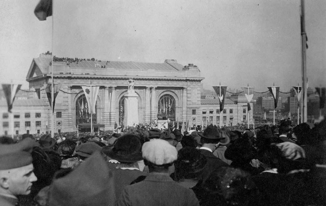
One hundred and five years ago today, on November 1, 1921, more than 100,000 people came together to witness the site dedication of the Liberty Memorial.
In attendance were Vice President Calvin Coolidge and the five commanders of the World War I Allied forces:
• Admiral Lord David Beatty, Great Britain
• General John J. Pershing, United States
• Lieutenant General Baron Jacques, Belgium
• General Armando Diaz, Italy
• Marshal Ferdinand Foch, France
It was the first time these five military leaders had gathered together in one place. All five arrived in Kansas City by train at Union Station.
Built as a lasting tribute to those who served in World War I, the Liberty Memorial officially opened in November 1926 and celebrates its centennial anniversary this year.
The Liberty Memorial was designated a National Historic Landmark in 2006, and in 2014, Congress formally designated the site as the National WWI Museum and Memorial.


SantaFeTow retweeted

Today's weather is quiet & cloudy but it will become active again tomorrow. Higher gusts and PM/eve. storms are expected. Odds are, there will be multiple bands of storms moving SW to NE with heavy rain & possibly severe wind gusts. A quick spin-up is possible! @fox4kc


Started out as a call for a tow, of a
Ford GT 2020 Heritage Collection.
Then Mooney, being a seasoned tower and all around helper, got it started.
Driver got to drive his majestic vehicle home.
It sat a month at the @KCAutoMuseum for #moparmonth ! Huge turnout!


SantaFeTow retweeted

Tonight it's eastern New Mexico and the Texas Panhandle. Monday it's Oklahoma, Kansas and North Texas, and Dallas is now in it. Damaging winds and a few tornadoes are possible.

SantaFeTow retweeted
Oak Creek in Sedona, Arizona rose 12 feet overnight. This was it before sunrise.
Video: El Portal Sedona Hotel
SantaFeTow retweeted
The San Juan River ran right over Highway 160 in Pagosa Springs, Colorado this afternoon, and it's still rising tonight.
Video: Cade White
SantaFeTow retweeted
The whole town of Manassa, Colorado is being told to leave tonight.
The sheriff says the Conejos River will flood as high as last time or higher, and faster.

SantaFeTow retweeted
If you drive EV, we’ve got you!
We do a truckload of EV training on the most efficient and safe ways to hook up and transport your vehicle. As you should expect from us.
It’d be an honor to help you.
Dial ** TOW
when you need us.
Meanwhile, stay safe out there.


SantaFeTow retweeted
SPC UPDATE -- All of the Metro is now included in the Level 2 risk area for severe storms tomorrow (Monday). Expect bands & clusters of storms with a severe wind threat & a brief spin-up potential into Monday night. @fox4kc


SantaFeTow retweeted

The City of Sedona said residents who live in evacuation zones 8, 9 and 10 are in a GO status due to flooding. Here's a video from the creek near Tlaquepaque.
MORE: 12news.com/article/weather/r…
SantaFeTow retweeted

Imagine sitting on top of a mountain, thinking you are safe, and a massive grizzly casually runs up it.
I can't believe how athletic these bears are. If you are on the menu, nothing will stop it.
A couple years ago there was a hiker in Waterton Park that tried to out climb a grizzly who just kept climbing up to him. He had to get rescued off.

SantaFeTow retweeted

Colorado built a $15 million bridge so animals can cross the highway. Wildlife deaths dropped 91% in 10 months. Moose included.
📸: source image


SantaFeTow retweeted

Quite the trend on the NAM (along with some of the other models), depicting a faster and stronger trough on Monday.
This has resulted in a trend towards the Sfc. Low, and moisture being pulled further north. Low-level dynamics are still strong over the main risk area (Central OK/KS), but a setup like this, should it verify, will support more a linear or sloppy mode (mainly dependent on instability) of storms along, or just ahead of the cold front.
Damaging winds and tornadoes remain the primary hazards for Monday afternoon-evening, despite these trends.
SantaFeTow retweeted

⚠️ Some storms could be severe on Monday. There will likely be two rounds: midday & evening. The greater severe threat is currently for the evening round, which is mainly between 8 p.m. and midnight. kmbc.com/weather @KMBC #Mowx #Kswx #Kcwx


