

Official account of the @TXGLO Save Texas History program, highlighting the conservation of historic documents and promoting the study of Texas history.
Austin, TX
Joined July 2013
- Tweets3.9K
- Following173
- Followers7.5K
- Likes1.6K
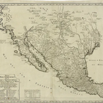





Mexican cartographer José Antonio de Alzate y Ramirez’s “New Geographic Map of North America” (1768) was a landmark in Spanish and Texas cartography. [1/3]

Drawing on official Spanish sources, it was the first printed map to identify Texas as a distinct geographic region. Alzate y Ramirez documented contemporary knowledge of New Spain, California, and the present American Southwest during the Enlightenment era. #MapMonday [2/3]
1
51

John Hill Westbrook, the Southwest Conference’s first Black varsity football player, was born today in 1947 in Groesbeck, Texas. [1/3]

Westbrook began his studies at Baylor University in 1965, where he overcame racial discrimination and secured an athletic scholarship. On September 10, 1966, he broke the conference’s racial barrier during a game against Syracuse. [2/3]
1
1
91
Westbrook later ran for Texas Lieutenant Governor in 1978. He died in Houston in 1983. [3/3]
Learn more:
tshaonline.org/texas-day-by-…

1
66
Don't forget that tomorrow is Day 1 of our 2026 Save Texas History Symposium at the Bullock Texas State History Museum in Austin!
This year's theme, “A Lone Star Among Many: Texas and the Making of America,” highlights the dynamic relationship between Texas and the nation.

We have a wonderful lineup of speakers for our Student Research Showcase, and we can't wait for you to join us!
More details here:
sthsymposium.vfairs.com/#
73
Commissioner Dawn Buckingham, M.D., and the GLO’s Save Texas History Program encourage Texans to “give the gift of Texas history” this holiday season. [1/4]

"As a ninth-generation Texan celebrating the history of our great nation is special, and with this year's ornament, we honor America's 250th birthday with a beautiful Christmas decoration depicting the importance of the U.S. Declaration of Independence." [3/4]
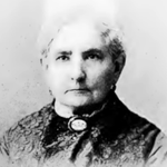
Christoph Conrad Stremme, a German-born architect, engineer, and inventor, immigrated to Texas in 1852 and made lasting contributions to the state. [1/3]

At the Texas General Land Office, he created detailed county maps and designed the agency’s headquarters, now known as the Old General Land Office Building and the home of the Capitol Visitors Center. [2/3]
1
1
101
He also led the short-lived Photographic Bureau, which innovated in reproducing agency maps through photography. #SaveTexasHistory
Learn more:
medium.com/save-texas-histor…
68
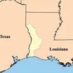
Today in 1806, American and Spanish commanders James Wilkinson and Simón de Herrera agreed to establish the Neutral Ground to prevent conflict over the disputed Louisiana-Texas border following the Louisiana Purchase. [1/2]

The agreement placed the territory between the Arroyo Hondo and Sabine River under neutral status, though the Adams-Onís Treaty (1821) eventually granted it to the United States. [2/2]
Learn more:
tshaonline.org/texas-day-by-…
75
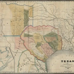
After Mexico gained its independence from Spain in 1821, its efforts to usher in new populations of citizens transformed Texas. [1/3]

Cartographers, including H.S. Tanner, David H. Burr, and J.H. Young produced maps that illustrate how migration, land speculation, and political developments shaped Texas’ evolving cultural identity and contributed to its emergence as a distinct political region. #MapMonday
[2/3]
1
74