

Meteorologist | Emergency Management Associate | Foster Mom for many 🐱
Maryland, USA
Joined December 2012
- Tweets2.5K
- Following942
- Followers313
- Likes1.3K






Shae Parsley retweeted

Without your help, due to the latest change by @TwitterDev @LastQuake will have to stop its operations. We publish more than 1 000 tweets a month and are not eligible to the free option. Being a NGO we cannot afford to pay @elonmusk
Please RT to try to convince them to change

Shae Parsley retweeted

April 16, 2011, is a day that is etched into my memory forever. For many, it is a day they wished they could forget.
It was the largest one-day tornado break on record in NC, and it took 24 fellow North Carolinians from us.
I'll share some thoughts today.
1/ #April16Tornadoes
If you live in this area, be aware, ensure you have a way to access weather information, and heed any warnings that are issued.

A regional outbreak of #severe #thunderstorms is expected Wednesday and Wednesday night including damaging winds, large #hail, and #tornadoes. Be weather aware and have a reliable source for watch/warning info such as NOAA Weather Radio. #MSwx #Alwx #LAwx #ARwx #LAwx #TNwx


Shae Parsley retweeted

NWS will replace its “Advisory” and “Special Weather Statement” headlines with plain language headlines that more clearly describe hazards. This will take effect no earlier than 2024 NWS.
“Watch” and “Warning” headlines will remain unchanged.
Read more: weather.gov/news/210403-haza…


Shae Parsley retweeted

2020 was a historic year of extremes.
There were 22 separate billion-dollar weather and climate disasters across the United States, shattering the previous annual record of 16 events, which occurred in 2017 and 2011. Learn more from @NOAAClimate: climate.gov/news-features/bl…

ALT 2020 Billion Dollar Disasters are highlighted on a map of the United States.
One of the newest members to the Itty Bitty Forecasting Committee 🐱
((Never-ending Kitten Season 2020))


Sterling radar (KLWX) remains down; thankfully no significant weather expected for the DC area for the next few days (aside from some passing showers Thu night into Fri night)

LWX issues Public Information Statement (PNS) at Sep 23, 9:43 AM EDT ...KLWX (STERLING VA) WSR-88D OUT OF SERVICE UNTIL FURTHER NOTICE, , UPDATE 1... mesonet.agron.iastate.edu/p.…
And we’ll likely have Beta in the next advisory...

With the naming of Subtropical Storm #Alpha, we've officially entered the Greek Alphabet for named Atlantic storms this year.
We've made it as far as Zeta one time on record, in 2005.
Visit hurricanes.gov for the latest.


Shae Parsley retweeted

I’m currently on the causeway. I’ve never seen the bottom of the bay. It looks empty as the wind pushes the water out. @mynbc15 #alwx #HurricaneSally #gulfcoast – at Alabama, USA
Shae Parsley retweeted

Echoing the thoughts of our colleagues on #wxtwitter, deep convection with Tropical Storm #Sally is producing a lot of gravity waves as seen by #GOESEast.
Think of it as dropping a large stone in water: ripples emanate outward. In the atmosphere, the stones are t-storms.
Shae Parsley retweeted
A reminder we're still a week or so away from "peak" hurricane season. Don't wait for the warning to be issued. Plane ahead and be #WeatherReady
weather.gov/safety/hurricane…


Shae Parsley retweeted
Dangerous flash flooding is possible this afternoon & evening due to heavy rain & slow moving storms. Stay weather aware & have more than 1 way to receive our alerts. Remember, do not cross flooded roads! Visit weather.gov/washington for the latest info. #vawx #mdwx #dcwx #wvwx

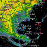
#Isaias kept me locked in the office over the past several days on tropical activation (we won’t mention the crazy hours). What a pleasant surprise it was to be able to walk out my front door into the eye as it passed overhead. Not bad for a TS 🤓
4.59” of rain total, min 1002mb


