






TDS Weather retweeted
NOVEMBER STARTS OFF ACTIVE?
It’s been a quiet and mild stretch of weather across the Midwest, but that could quickly change as we head into November.
Forecast data continues to suggest a strong area of low pressure developing and moving from the Rockies east/northeastward across United States from November 1–3.
While the exact track and intensity of this system will ultimately determine where the greatest impacts occur, there is the potential for widespread rain, areas of heavy rain, strong thunderstorms, and even strong non-thunderstorm winds across portions of the region.
There is still plenty of uncertainty this far out, but this is a system we’ll be watching closely as we get closer to the forecast period. November could be starting off with a much different weather pattern than what we’ve experienced recently! #INwx #ILwx #OHwx #MIwx #WIwx

⏰ DON’T FORGET: TIME CHANGE THIS WEEKEND! 🍂
Daylight Saving Time comes to an end this weekend, meaning we’ll “fall back” one hour early Sunday morning, November 1st.
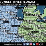
That also means earlier sunsets across the region. 🌅 As shown on our map, sunset will occur around 5:40 PM in Indianapolis, with areas farther west seeing sunset closer to 5 PM and locations farther east remaining in daylight a little longer.
The good news? We gain an extra hour of sleep!
📅 Saturday night → Sunday morning
⏰ Turn your clocks back one hour
And if you enjoy getting outside after work, it’s time to start planning around those increasingly early sunsets!
#INwx #ILwx #OHwx #KYwx #MIwx #WIwx #DaylightSavingTime #TimeChange

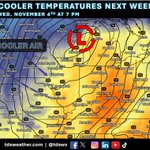
CHILLIER TEMPERATURES IN THE LONG RANGE? 🥶
While we’ll finish out October mild across the region, a larger storm system could signal a change in the weather pattern as we head into early November.
A strong area of low pressure and an associated cold front are forecast to move across the region by mid to late next week. While this system will bring rain, much colder air looks poised to surge in behind the front.
Current data suggests temperatures could return to near or even below average levels toward the end of next week. Could this be our first real taste of November chill? 👀
We’ll continue to monitor how this pattern evolves over the coming days! #INwx #ILwx #OHwx #MIwx #WIwx

NOVEMBER STARTS OFF ACTIVE?
It’s been a quiet and mild stretch of weather across the Midwest, but that could quickly change as we head into November.
Forecast data continues to suggest a strong area of low pressure developing and moving from the Rockies east/northeastward across United States from November 1–3.
While the exact track and intensity of this system will ultimately determine where the greatest impacts occur, there is the potential for widespread rain, areas of heavy rain, strong thunderstorms, and even strong non-thunderstorm winds across portions of the region.
There is still plenty of uncertainty this far out, but this is a system we’ll be watching closely as we get closer to the forecast period. November could be starting off with a much different weather pattern than what we’ve experienced recently! #INwx #ILwx #OHwx #MIwx #WIwx
WARM AGAIN THIS WEEK! ☀️
Mild weather will continue across the region this week and into the weekend, thanks to a strong upper-level ridge keeping colder air at bay.
Temperatures are expected to run 10–20° above average across much of the region this week, with another stretch of unseasonably warm weather on tap! #INwx #ILwx #OHwx #MIwx #WIwx

ANOTHER DRY WEEK AHEAD 🌤️
While the weather has been very pleasant across the region, we could certainly use some rain! Unfortunately, many of us are going to miss out on meaningful rain chances through the end of this week.
A few areas across the northern Ohio Valley and Great Lakes could see some precipitation late in the week, but rainfall amounts are expected to remain light, with little to no appreciable accumulation expected.
For much of the region, it looks like the dry pattern will continue for at least another week. 🌾💧 #INwx #ILwx #OHwx #MIwx #WIwx #AGwx


🍂 ANOTHER GREAT FALL WEEKEND AHEAD! 🍂
It’s going to be a beautiful weekend across the region, with pleasant temperatures in the 70s and plenty of sunshine! ☀️
If you’re looking to get outside and enjoy the fall colors, this weekend will be a great opportunity. Much of Indiana is seeing moderate to even high levels of fall color, with more vibrant foliage continuing to spread across the state. 🍁
Get outside, enjoy the sunshine, and take in the fall scenery while you can! #INwx #fall #foliage


There is still plenty of speculation about what the 2026–27 winter season may have in store for the Midwest and the rest of the U.S. ❄️
Here’s a look at NOAA’s Seasonal Forecast System (SFS) snowfall prediction for the December–February period. The latest outlook continues to suggest the possibility of plenty of snowfall across much of the Ohio Valley and Great Lakes region.
Of course, seasonal snowfall forecasts this far out come with plenty of uncertainty, but it’s an interesting early look at what the SFS is currently projecting for the upcoming winter. 🌨️ #INwx #ILwx #OHwx #MIwx #Snow #winter #winteriscoming

Snow and ice will be here before you know it! Keep your crews ahead of the storms this winter with reliable forecasts from tdsweather.com and access to our meteorologists 24/7. Post-storm reports by zip code available in our custom dashboard. Inquire: [email protected]
#INwx #ILwx #OHwx #MIwx #WIwx #winter #weather #snow

🌤️ Dry weather continues across the region!
For those hoping for some much-needed rainfall, the outlook over the next week isn't looking particularly promising. Dry conditions are expected to continue through the weekend and into next week.
A cold front will move through around the middle of next week, and while it could bring some areas of rain, the overall environment looks fairly dry. As a result, widespread or significant rainfall may be hard to come by.
📉 Model data over the next 7 days shows very little precipitation across much of the southern Great Lakes and Ohio Valley, with higher amounts expected farther west near the main area of low pressure.
Bottom line: Don't expect much rain over the next week. 🌤️ #INwx #ILwx #OHwx #MIwx #WIwx #AGwx #rain

With winter just around the corner, it’s always fun to take a look at some of the predictions and forecasts being released for the upcoming season. One of the most familiar is the Farmers’ Almanac.
Every year, the publication releases its long-range seasonal outlooks, but few are as anticipated as its winter forecast. So, let’s take a look at what the Farmers’ Almanac is predicting for the Midwest for winter 2026–2027! ❄️
"The outlook for the Great Lakes and Midwest is cold, with snowy periods. Temperatures should average near normal overall, but that does not mean winter will be mild. Chicago, Indianapolis, and the rest of the zone should expect fast-moving clippers, sudden cold snaps, and brief snowy periods, although milder breaks may frequently interrupt the wintry weather. Farther north, the Great Lakes could see sudden snow squalls, blustery winds, and bursts of bitter cold, and snowbelt communities downwind of the lakes should be ready for them." #INwx #ILwx #OHwx #MIwx #WIwx #winter #snow

If you’re waiting for cooler air, unfortunately, there’s not much in the long-range outlook to get excited about. 🥵
The Climate Prediction Center (CPC) expects above-average temperatures to continue into November across much of the central and eastern U.S.
That doesn’t mean we won’t see some brief shots of colder air from time to time, but at this point, those colder periods don’t look likely to stick around long before warmer temperatures return.
In other words, if you’re ready for more consistent mid to late fall temperatures, you may have to wait a little longer. 🍂 #INwx #ILwx #OHwx #MIwx #WIwx


The October ENSO forecast data is really interesting. We’re potentially looking at a significant drop from a record-strength El Niño at the start of winter, with ENSO weakening quickly through the end of winter and into spring. A couple of thoughts on this, this is based on experience and opinion, not a forecast at this range:
A rapidly weakening ENSO in 2027 could throw a wrench into the typical expectations for the Midwest. While a warm winter with near- or below-normal precipitation may be the favored outcome based on the current ENSO signal, a quicker-than-expected transition could introduce some surprises.
One possibility? A more back-loaded winter season across the Midwest, with the more impactful winter weather coming later in the season rather than early.
There is still a LOT of uncertainty this far out, but the evolution of ENSO over the next several months will be something I’ll be watching closely. Sometimes, the transition is just as important as the starting point. #INwx #winter #snow


