

Assistant Professor of Meteorology, Penn State Certified Consulting Meteorologist (CCM) expertise in cloud and storm dynamics
State College, PA
Joined May 2020
- Tweets1.5K
- Following236
- Followers986
- Likes306


John Peters retweeted

Let’s congratulate Dr. Dan Chavas, the recipient of the 2024 STAC Outstanding Early Career Award!
Pictured: Dan Chavas (awardee) with Naoko Sakaeda and Pablo Santos (conference co-chairs).


John Peters retweeted

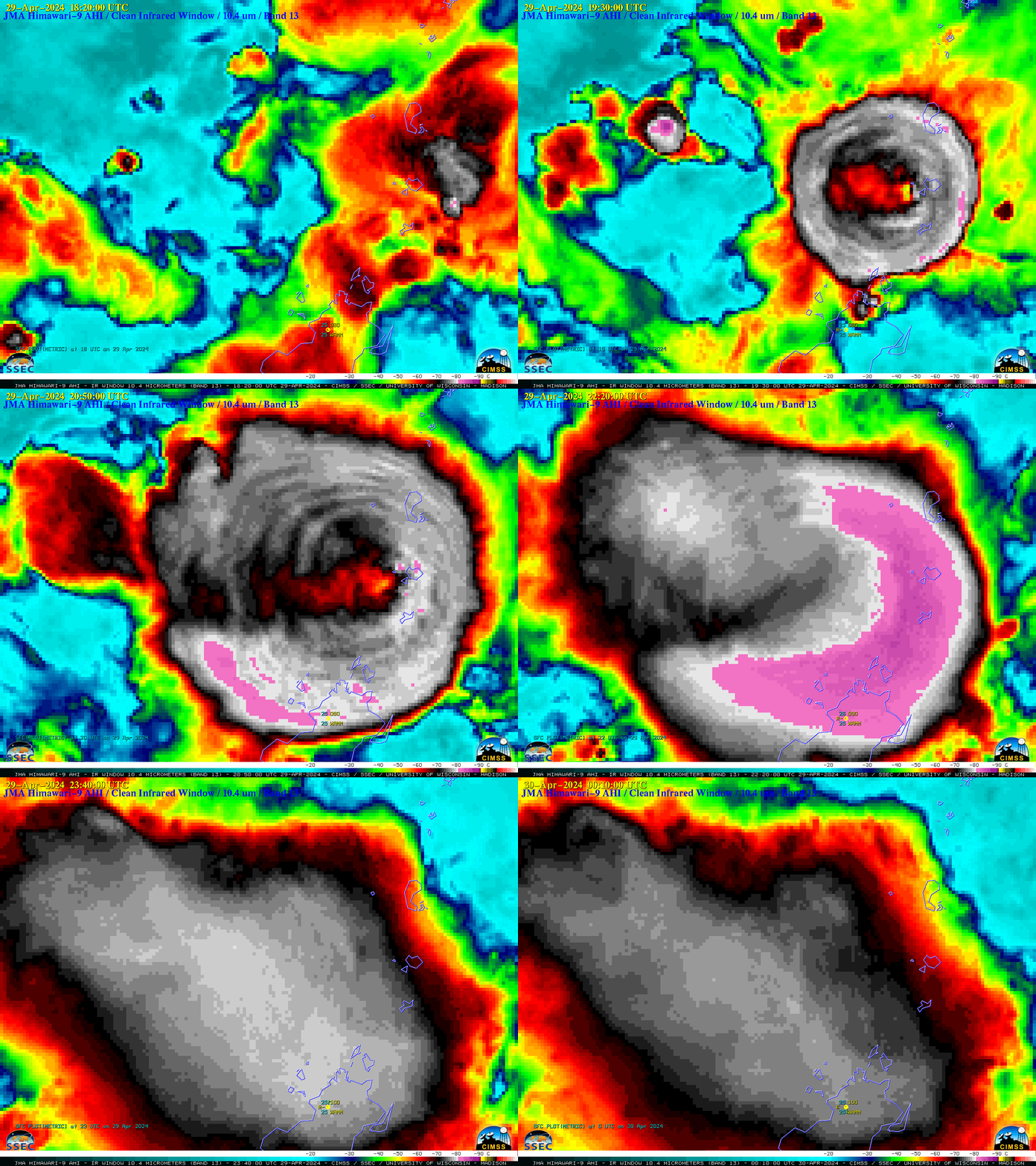
Infrared images from @JMA_kishou #Himawari9 revealed impressive cloud-top gravity waves associated with an eruption of #Ruang in Indonesia - coldest cloud-top infrared brightness temperatures reached -90ºC (yellow pixels) immediately after eruption onset: cimss.ssec.wisc.edu/satellit…

John Peters retweeted

Seeing the behavior of volcanic ash clouds (this from #Ruang) on satellite is always really neat. The warmer center of it is actually higher up, in the stratosphere, and the updraft weakening can be seen by the cooling off plume's center as it sinks back towards the tropopause

John Peters retweeted

JUST IN: First aerial footage captured just minutes ago of the newly opened volcanic fissure near Grindavík, Iceland.
It is estimated to be about 3 km long!
John Peters retweeted

Eldgos er hafið norðan við Grindavík. Það sést á vefmyndavéĺum og virðast vera staðsett nærri Hagafelli. Eldgosið hófst kl. 22.17 í kjölfar skjálftahrinu sem hófst um kl. 21 vedur.is/um-vi/frettir/jards…

ALT Photo: Halldór Björnsson/Veðurstofa Íslands
John Peters retweeted

Excited to say that my lead-author paper "The Influence of Midlevel Shear and Horizontal Rotors on Supercell Updraft Dynamics" with James Ruppert, Matt Flournoy (@mattnado), and John Peters (@UpdraftwMax) is out in Journal of the Atmospheric Sciences EOR! journals-ametsoc-org.ezproxy…
John Peters retweeted

NOW - Large crack opens up in the town center of Grindavik, Iceland.
teapawt.org/WxNB_/status/172407621…
John Peters retweeted

A Volcanic Eruption is Imminent in Iceland; Evacuations Underway, Erupti... youtu.be/CaInCp8h2BM?si=ynbH… via @YouTube #geology #iceland
Note: A volcanic eruption at the Reykjanes volcano may not end up occurring but in my opinion is more likely than not in the next 2 weeks.
John Peters retweeted

Very strong #Tornado near Newton Georgia today ripping up trees and tossing them hundreds of feet into the air! This is most likely the strongest point of its lifecycle.
#gawx #wxtwitter
@DJIGlobal
@ReedTimmerAccu
@Sierra_Lindsey3 – at Georgia, USA
John Peters retweeted

#Kilauea is currently erupting from the #Halemaumau summit crater. HVO will be releasing an update soon. USGS livestream is showing the action. youtube.com/usgs/live #Hawaii #lava #eruption


John Peters retweeted

A timelapse of the Mount St. Helens eruption made from photographs stitched together that were taken over a span of about 40 seconds by Gary Rosenquist.
John Peters retweeted
8:32 a.m. May 18, 1980: Mount St. Helens erupts and becomes the deadliest and most destructive volcanic eruption in U.S. history.
This hiker witnessed the eruption from neighboring Mount Adams, a moment captured by photographer John V. Christiansen.

ALT A series of two photographs depicting a hiker wearing yellow gaiters and an orange backpack standing on a snowy mountain summit, reacting to a violent eruption of volcanic ash on the neighboring mountain. In the first image, the hiker holds their hands on the side of their head, as if in shock. In the second image, the hiker is seated as they watch the eruption, as if overwhelmed by the moment.
John Peters retweeted

Storm chaser @BrandonCopicWx just witnessed a very large, extremely dangerous & rain-wrapped tornado moments ago (around 6:15PM CDT) southwest of Oakland, NE. Here's a timelapse from his @cyclonePORT stream in the RadarOmega app. #NEwx
John Peters retweeted

Nice to work with @UpdraftwMax on this. Special thanks to @dbmechem and @Gewitter_Blitz.
"Seasonal controls on isolated convective storm drafts, precipitation intensity, and life cycle as observed during GoAmazon2014/5" acp.copernicus.org/articles/…
John Peters retweeted

Today was an emotional roller coaster. Still processing. But this. This here - there is nothing like this feeling. Incredibly grateful I’m able to chase like I do. Taken near Ottumwa, IA #iawx #tornado #tornadoes


John Peters retweeted

The Wapello County tornado seen from 4 miles south of Hedrick.
🎞: Lauren Sylvester
#iawx