

Meteorologist @kpixtv https://teapawt.org/t.co/na20J4JBzQ
San Francisco, CA
Joined February 2011
- Tweets1.9K
- Following17
- Followers2.9K
- Likes206


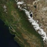




This morning’s beautifully placed conveyor belt (snow blower) gliding directly along the spine of the Sierra. View from above here is matched with result on the ground! #cawx #sierrasnow
Today’s installment of “Hey what’s that cloud doing?” Jellyfish clouds: The body is an altocumulus cloud. The tentacles are precipitation (rain or ice crystals). The tentacles are not getting pushed along as fast as the body up at a higher altitude so they drape behind #cawx

Take a moment to enjoy California from 450 miles up on this gorgeous April 9 2025. The green grass of early April is beautifully pared with a glistening white Sierra snowpack (99% of average!) #cawx

Today's satellite of California is what Inigo Montoya would call "cumuliform galore". Hard to distinguish all those building cumulus cloud over the Sierra from the 100% of avg snowpack underneath!
Today's satellite: That beautifully formed mid-latitude cyclone is why we went from 80's yesterday to 60's today. Possibility for rain is now sprinkled throughout the forecast well into next week... Stay tuned!
3.7 magnitude at 7:02AM
Felt like a short little jolt for me in the city. That’s a historically reminiscent location on the San Andreas. Anyone else feel it? You can let USGS know here: earthquake.usgs.gov/earthqua…


What does a weak La Niña mean for the Bay Area's winter weather forecast... youtu.be/AGjzXFNenp0?si=8tvE…

The heroism and the artisty of this is so incredible. Thank you @CAL_FIRE for having our backs!
@WilsonKPIX with the spectacular capture and share from yesterday.

Just getting a chance to sort through everything from yesterday's #KellerFire in the Oakland Hills. Remarkable airshow by @CAL_FIRE, highlighting the readiness for the conditions, AND those C-130H tankers, added to the fleet barely six week ago....
Spotted from Mt Diablo above the marine layer tonight. Smoke from the #ParkFire drifting our way. Most will stay elevated but some will filter down to the ground overnight. No air quality advisories issued as of now. Stay air aware here: fire.airnow.gov/
Not a cloud in the sky! That’s all smoke visible from SF right now courtesy the #ThompsonFire. Upper level winds will continue delivering that smoke directly overhead into tomorrow. Keep tabs on air quality where you live: fire.airnow.gov

#pointfire is producing "Unhealthy" air quality right through the most heavily populated corridor of Sonoma County. Stay air aware here: fire.airnow.gov/


For anyone who's ever wondered what a "compressed marine layer" means, this morning's time-lapse shows it beautifully. High atmospheric pressure compresses the marine layer in this 3hr loop😮 Now it can't reach inland valley's where it will still be close to 90° today.
From 80° on Thursday to snow on Bay Area peaks Saturday. A deep dive into this weekend storm and if we see any more after this one:
youtu.be/_jEHQeijJYk?si=4jVI… via @YouTube
Sound up! Walking to our virtual set for our 8 PM newscast on PIX+ and greeted by a perfect example of how tonight‘s going to go on and off for most of the Bay!
Sierra snowpack now 104% of avg!
Beautiful detail of current snowpack in this fly though. If you melted it all, there'd be an average of 2ft of standing water at any given location from north to south. Biggest reservoir in the state....by far.
Friday’s 190 mph winds. Saturday’s tornado warning in San Benito County. Today’s extension of the blizzard warning. Here’s tonight‘s in depth look at the current storm….and what comes next: youtube.com/watch?v=QTFBzK9u…

What’s supercharging this weekend’s potentially record setting snow? Several factors… but one really BIG one! youtu.be/8-PV9kJq6V0?si=46R1…

The "worms" are back. "Narrow cold front rainbands" is the technical way of referring to them. Right on schedule, brief downpours & gusty winds have developed along this afternoons cold front. City and Peninsula will notice these shortly.
What was it about this storm that created such intense wind for us and then such relentless, historic rain to our south in southern California? An explanation:
youtube.com/watch?v=fXa8TJil…
In light of the impactful nature of recent storms, we've been doing long format analysis and forecasting on both streaming and @YouTube. Here's tonight's detailed breakdown of the current storm....and what comes next.
youtube.com/watch?v=oUNhXNqH…
