UK Thunderstorm lover, Photography sometimes, and chasing!
Joined June 2025
- Tweets1.8K
- Following350
- Followers373
- Likes35.6K
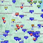



Some localised fog, thick in places, has developed - take care as it is being reported as rather dense in places.
This map shows reported visibility, in m.

Lots of thunderstorms being triggered in the channel tonight - some may clip the south coast in the process and bring the risk of some small hail.

3
80
A YELLOW warning for Ice has been issued by the met office for areas of Eastern Scotland and NE England.
This is the first warning for ice since the 12th March 2026.

As we head into next week, it is possible that a low pressure system will collide with much colder air Monday night into Tuesday morning - Potential for some snow on the hills, maybe further down.
Details will change as where this could occur exactly is uncertain at this stage..

10
387
As we head towards the end of this week, we are going to see a brief spell of chilly northerly winds temporarily bringing colder temperatures to a large portion of the UK, giving air frosts for almost everyone at some point in the week.
2
10
545
Heading towards the end of this week, some northerly air will make it noticeably colder and frosts are likely on both Thursday into Friday (Image 1) and Friday into Saturday (Image 2).
Snow is possible on the hills and mountains of Scotland, maybe a bit lower in some spots.


Very dangerous conditions out there near Heathrow. You can barely see the road from this traffic camera - imagine driving in this!

Extremely dense fog ongoing: Heathrow airport has also now reported a visibility of just 10 meters. Google Maps suggests multiple crashes have occurred near the area due to this localised extremely dense fog, with absolutely awful traffic conditions.


Some extremely dense fog developing in some areas. Visibility of just 10 meters has been reported in Northolt.

Furthermore, fog is starting to develop in areas of SW Northern Ireland. The Met Office have just issued a yellow warning to cover that threat.

Fog is starting to develop across the country as for the third night in a row a Yellow Fog Warning is in force.
The map to the left shows observed visibility in meters.


3
477
Fog is starting to develop across the country as for the third night in a row a Yellow Fog Warning is in force.
The map to the left shows observed visibility in meters.
Looking at current visibility reports, shown here in m via weatherobs.com, you can see already the extent of dense fog across southern and central England, and areas of wales.

For the third day running, A yellow fog warning has been issued by the Met Office. Take care on the roads tomorrow morning as fog may be dense.


Fun fact: under the current met office system, a Red weather warning for fog is impossible and can't be issued.
This is because there are no extreme impacts listed on impact tables, needed for a red warning.

Tonight an active cold front will move through the UK, bringing strong gusts to western areas. Then, a deep low will effect the NW of Scotland into the next day.
This outlook shows the likely wind gusts to expect across the UK in the next 24 Hours. These are not MO warnings.

5
579