






A Tropical Disturbance Destined for History
Exactly one year ago today, a tropical disturbance was classified as a tropical storm. Its name was #Melissa. Just one week later, it would become one of the strongest western hemisphere hurricanes on record. Although weakening from that peak, it subsequently made a catastrophic Category 5 landfall on western Jamaica about 4–5 hours thereafter.
Given the exceptionally favorable environmental conditions in the northwestern Caribbean, a historic Cat 5 peak intensity seemed probable even while it was still a struggling, sheared, and weak tropical storm. The progression looked like this:
* Late October 20 EDT: While it was still Invest 98L, a track into the northwestern Caribbean already raised the odds of not just a major hurricane but a Category 5 peak, given the highly favorable thermodynamic environment.
xitter.cf/Mr_XMusk27/status/1980…
* October 21 EDT: After classification as a still heavily-sheared tropical storm, the Cat 5 probability was assessed at no less than 50% if the NW Caribbean track materialized, and that track was described as becoming increasingly probable.
xitter.cf/Mr_XMusk27/status/1980…
* October 22 EDT: With the system still a minimal, struggling tropical storm, the intensity ceiling under the favored NW Caribbean track was noted as extraordinarily high — conceivably approaching Atlantic basin records for lowest pressure and/or maximum sustained winds — while a Category 5 was called the most likely outcome (~60%).
xitter.cf/Mr_XMusk27/status/1981…
Note: the linked posts are from my prior account, which was compromised and is no longer accessible. Please do not reply or engage there. The screenshots are also attached for reference.
Once vertical wind shear eased and Melissa moved into the northwestern Caribbean, the storm rapidly intensified to a peak of 190 mph/892 mb before its aforementioned Category 5 #hurricane landfall in western Jamaica — aligning with the high ceiling noted in those early posts.


Melissa Likely to Stay South of Jamaica and Become a Category Five Hurricane by Monday Evening:
Although tropical storm #Melissa remains a heavily-sheared and vertically misaligned system, it’s this lack of structural integrity that will likely cause it to miss hitching a ride with a passing mid-latitude trough to the north (in contrast to what has been persistently predicted by the more easterly model solutions such as the GFS) and have that corridor closed as the ridge builds back in and imparts a westerly to west southwesterly steering flow in about 48 to 60 hours. In the meantime, very weak steering currents should result in a slow northwesterly or north-northwesterly movement towards the aforementioned weakness. Despite this being by far the most probable scenario (80%), a more northerly to northeasterly track towards Hispaniola can’t be completely ruled out (20%). But, as noted above and over the past couple of days, that would require Melissa to become much better vertically stacked with sufficient depth. Given the continued strong and persistent westerly VWS, that seems pretty unlikely to occur. Consequently, I anticipate a track that has Melissa moving slowly northwestward towards the island of Jamaica during the next 48-60 hours followed by a sharp turn back to the west…which would keep it a good distance south of there. Beyond that point, I’m projecting Melissa to continue a general westward trajectory that takes the center further into the NW Caribbean through the upcoming weekend and into early next week. This track forecast is very similar to the latest (5 pm EDT) NHC version…albeit just a little south of their 120 hour forecast point.
If this particular track scenario comes to fruition, it’s not too hyperbolic to say that the intensity forecast has an extraordinarily high ceiling. I mean we’re talking cathedral-type levels, here, and it’s conceivable that Melissa could even approach the NATL basin records for lowest central pressure and/or maximum sustained wind speeds.
That said, it’s impossible for any of us to make any definitive declarations simply because, despite the expected pristine environmental conditions potentially awaiting Melissa beyond 72 hours, the inner-core dynamics are rather unpredictable and could very well act to limit the more extreme possibilities. Nonetheless, and as mentioned a couple days ago, a category five peak intensity appears to be the most likely (60%) outcome with this particular forecast track once Melissa gets into the NW Caribbean by the end of the weekend and early next week. In the shorter-term, however, intensification should be relatively slow to occur until the shear begins to abate in the 48-60 hour range and I’m not expecting Melissa to attain #hurricane status until after that time.
Taking all the aforementioned into account, here’s the precise center location and corresponding MSW intensity I’m forecasting for Melissa early on Monday afternoon:
1800z (10/27/2025):
16.0 N
78.9 W
MSW: 120-130 (125) kt
140 n mi SSW of Savanah La-mar, Jamaica
Forecast track shown in *yellow* on the attached map of interpolated 00z guidance solutions.


I’ll be providing a detailed analysis of the objective data in the next few days showing that the official landfall intensity for #Melissa is significantly overestimated.
Melissa was still a powerful Category 5 #hurricane when it crossed the western Jamaican coastline, but it was no longer anywhere close to a sub-900 mb storm, nor did it retain 160 kt maximum sustained winds at landfall.
It is extremely important that one analyze the available data completely devoid of any inherent bias or emotion that can interfere with complete objectivity. In other words, a desire to retain a record event or too much reliance on continuity can significantly affect a wholly objective view of these data. For me, I value the most accurate intensity estimate above all else and that is how I conduct all such analyses.
Independent Reanalysis of Hurricane Katrina’s Peak Intensity
This continues the Atlantic Category 5 #Hurricane series. Peak only. Landfall is a separate post.
Official NHC (TCR) — 28 August 2005, 1800 UTC
Winds: 150 kt (175 mph)
Pressure: 902 mb
Eye: 22 n mi at the 166 kt flight-level maximum
WxProbe Reanalysis:
MSW: 155 kt
MSLP: 902 mb
Reconnaissance
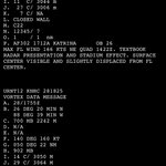
AF302 measured a 700 mb flight-level wind of 166 kt in the northeast eyewall at 1422Z. A higher wind could have occurred in the aircraft gap.
The last AF302 center fix was at 1500Z, with a pressure of 907 mb. The first NOAA3 fix was at 1755Z, which measured 902 mb. Nothing was flown in the eyewall for 175 minutes while the pressure fell 5 mb. The core was expanding across that gap: the eye was 22 n mi before it, 25 n mi at the 902 mb fix, and 28 n mi by 1923Z, and the radius of maximum wind had moved from 14–18 n mi out to 22 n mi. Given that expansion, the peak wind is treated as not missed, and the 166 kt remains the best reading.
Pressure
As mentioned above, the minimum was measured at 1755Z and again at 1923Z, 88 minutes later. The next fix was 903 mb, followed by 904 mb. The only hole is 1500Z to 1755Z. A transient value below 902 mb during that gap is possible, but not assured. Consequently, the official 902 mb is retained.
Structure
The RMW was 17 n mi from the center at the time of the 166 kt peak flight-level wind, which matched the same-mission cluster of 16–18 n mi. The mean of the nonzero R34 quadrants is 165 n mi at the peak hour. The 17 n mi inner core doesn’t erase that relatively large outer field.
Reduction Factor
RMW: 17 n mi
Pressure: 902 mb
R34: 165 n mi
The top bins (0.94, 0.95) are reserved for small-core, compact hurricanes with a central pressure <910 mb. Katrina meets the requirements on pressure, but not on size of its wind field. The 17 n mi wall is the 0.93 “width” path. The 165 n mi mean R34 is the reason the factor sits just below that, at 0.925, rather than on it.
The factor used is 0.925. 166 × 0.925 = 154 kt, which rounds to 155.
Pressure Check
CKZ, mean R34, 26.0–26.3°N, translation 10–11 kt, environmental pressure assumed 1010–1012 mb: 154–156 kt at 902 mb. In the equation, S is 0.80–0.89, so the relatively large wind field is accounted for in the solution.
Final Estimate
MSW: 155 kt (180 mph)
MSLP: 902 mb
RMW: 17 n mi
Time: 1700 UTC 28 August 2005
That is a 5 kt revision of the official wind, no revision of official pressure, and a one-hour shift of the peak from the 1800Z pressure hour to the hour assigned to the pair.
Series Comparison
Wilma and the 1935 Labor Day Hurricane remain 170 kt. Melissa is 165 kt. Katrina ties Andrew and Camille at 155 kt, with a larger RMW and a much larger R34 than either.


Looking Back on Hurricane Isaias — One Week Later
Hurricane #Isaias peaked as a Category 3 major hurricane (105 kt/120 mph, 959 mb) on October 9 as it was closing in on the Florida Panhandle. It weakened thereafter due to increasing wind shear and dry air entrainment. The center made landfall near Destin, Florida, at about 8:30 p.m. CDT on October 9 as a Category 2 (90 kt/105 mph, 971 mb).
The leading northern edge of the eyewall reached the Okaloosa Island/Fort Walton Beach area while the storm was still a legitimate Category 3 (100 kt); it then weakened by roughly 10 kt over the final 2.5 hours before the center actually crossed the coast.
On a personal note, I was positioned on the narrow and exposed road on Okaloosa Island between Fort Walton Beach and Destin, where wind gusts exceeded 100 mph as the western and southwestern parts of the eyewall moved through. This constituted the 46th U.S. mainland #hurricane eyewall intercept and the 19th major (as it was still a Cat 3 when the aforementioned northern edge moved overhead).
The storm produced an unusually broad and asymmetric wind footprint for its official Category 2 landfall intensity. Recorded gusts of 100+ mph occurred from the Pensacola City Hall area to Freeport (~55 nmi along the coast), including within the eyewall and extending well outside it in the western quadrant. In addition, hurricane-force gusts (74+ mph) spanned from Orange Beach, Alabama, to Beacon Hill just east of Mexico Beach (~120 nmi). The peak measured gusts reached 116–118 mph near Oriole Beach and Jay. A sting-jet-like feature on the western edge of the precipitation shield (during the onset of extratropical transition) helped drive the unusually strong western-quadrant winds. These winds caused widespread tree and power-line damage, roof losses on beachfront hotels and other structures, and collapsed gas-station canopies.
More than 900,000 customers lost power across Florida, Alabama, and Georgia (peak reports were around 910,000–911,000). Worst of all, at least nine fatalities were confirmed (six in Florida, two in Alabama, and one in South Carolina), mostly from falling trees and related incidents. Storm-surge inundation of roughly 5.6 ft was observed at Panama City Beach. A Flash Flood Emergency was issued for southern Okaloosa County due to torrential rainfall, with widespread 5–8 inch totals and localized amounts exceeding 12 (including over 11 inches near Mary Esther and Fort Walton Beach), producing major freshwater flooding that caused significant damage to homes and businesses in that area. Preliminary estimates of losses surpass $2 billion.
For residents of the western Florida Panhandle, Isaias is a storm that will be talked about for generations to come.

I’m sorry for the delay, but I finally completed the arduous editing process of the video I captured during #Hurricane #Isaias.
Here are the highlights of what I documented from Fort Walton Beach, Okaloosa Island, and Destin, Florida.
As you will see, it appeared that the winds were stronger when the western and southwestern parts of the eyewall moved over the Island.
Jeff here is arguing that the recent backloaded #hurricane seasons (quiet peaks, late activity, and more Florida Gulf hits) are mainly a climate-change stability signal from warmer summers.
The same period is better explained by the MJO. The predominant background state has been a warm AMO since 1995, with ENSO as the main seasonal modulator. On top of that, the MJO has been the primary subseasonal control.
In 2024, 2025, and this season, the MJO was unfavorable or weak through most of the peak (until after 9/16), then shifted more favorable later — exactly when activity increased. The 2023 season had the opposite alignment and produced a hyperactive peak instead.
Year-to-year timing differences track the MJO, *not* a uniform stability suppression. The MJO has been the dominant reason for the quiet peaks and late bursts in these years.

Boosting Andrew’s post and adding a talked about “backloaded season” theory to this. 🌀 Florida Can’t Get A Break! 🌀
11 Hurricanes in 11 Years! Here’s the crazy part… 10 of those hit the Gulf Coast! Coincidence? Cycle? Maybe… we’ve seen that before. But there may be a more scientific reason. Hear me out…
Many weather and climate scientists think it may be due to an increase in “backloaded seasons”. That means the first half of seasons are less active now-a-days, and the 2nd half are more busy.
So, since the Gulf is favored in fall, and tracks tend to go Northeastward due to autumn steering patterns, the storms are more likely to crash into Florida’s #Gulf Coast.
If you are interested, let’s dig a little deeper. During July/ August storms tend to move from east to west due to easterly steering winds in summer. So IF a storm forms in mid-summer it’s more likely to hit the #Florida East Coast. However it’s been very quiet lately in July and August lately. To the contrary, Sept and October have been active. Those storms are more likely to form in the W Caribbean and Gulf and hitch a ride on the Autumn Jet Stream, hitting the eastern side of the Gulf.
So… why are seasons backloaded? Probably warmer summers. It’s a bit complex, but over the longer term the mid-high level atmosphere is warming faster than the low-levels during summer. If it’s warmer aloft, there’s less vertical contrast, then the air below tends not to rise. Less rising air = less storms. It’s called stability. Thus quiet summers.
But then when the upper atmosphere starts to cool in fall, the hotter water and cooler air aloft has more contrast. Then the action begins… warm air rises and storms form. Since the favored area in fall is the Gulf, and the favored steering is towards the Northeast, it’s a recipe for more Gulf Coast #Hurricane hits.
If this theory is right - since warming will continue - it seems likely “backloaded” seasons may play a more prominent role in future #hurricane seasons and the target may increasingly be the Gulf Coast. Just a theory for now. But worth monitoring.

I’m sorry for the delay, but I finally completed the arduous editing process of the video I captured during #Hurricane #Isaias.
Here are the highlights of what I documented from Fort Walton Beach, Okaloosa Island, and Destin, Florida.
As you will see, it appeared that the winds were stronger when the western and southwestern parts of the eyewall moved over the Island.
As some may know, I always devote a minimum of 4-6 hours helping the survivors and affected community in the direct aftermath of every #hurricane. That commitment began with Katrina in 2005 and will continue for as long as I chase and document them.
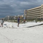
The main damage left in the wake of #Isaias around Fort Walton Beach has been large portions of roofs torn off beachfront hotels and freshwater intrusion of some homes and businesses from severe flash flooding.
At this point, I am beginning the long drive home and will edit video as I stop along the way.


Hurricane #Isaias delivered a very impressive wind footprint —especially for a Category 2 landfall — producing *recorded* gusts of 100+ mph from Pensacola City Hall to Freeport (~55 n mi along the coast), including within the eyewall itself and extending well outside of it in the western quadrant. Hurricane-force gusts (74+ mph) spanned from Orange Beach, AL to Beacon Hill — located just east of Mexico Beach (~120 nmi).
This broad and asymmetric wind field featured unusually strong winds in the western quadrant, driven by a sting-jet-like feature on the western edge of the precipitation shield as the storm began extratropical transition. As seen in the attached video, my intercept location endured the peak winds in the western and southwestern parts of the eyewall, with wind gusts well over 100 mph as well.
I’m sorry for the delay, but I finally completed the arduous editing process of the video I captured during #Hurricane #Isaias.
Here are the highlights of what I documented from Fort Walton Beach, Okaloosa Island, and Destin, Florida.
As you will see, it appeared that the winds were stronger when the western and southwestern parts of the eyewall moved over the Island.
As some may know, I always devote a minimum of 4-6 hours helping the survivors and affected community in the direct aftermath of every #hurricane. That commitment began with Katrina in 2005 and will continue for as long as I chase and document them.
The main damage left in the wake of #Isaias around Fort Walton Beach has been large portions of roofs torn off beachfront hotels and freshwater intrusion of some homes and businesses from severe flash flooding.
At this point, I am beginning the long drive home and will edit video as I stop along the way.
I will have a video compilation posted by later this afternoon or evening.
I documented the strongest winds on Okalossa Island, with fetch coming directly off the sound. That is the location where 116 mph wind gusts were measured.
As expected, #Isaias weakened on approach as the dry air was advected into the inner core. Even so, it was able to maintain most of its peak intensity (105 kt down to 90 kt), by remaining on the aforementioned “fast branch.”
Before Isaias — There was Michael
Today marks the eighth anniversary of the last Category 5 #hurricane to strike the U.S. mainland.
Hurricane #Michael claimed more than 50 lives and forever changed countless more. Sadly, many lost everything they owned—including homes their families had maintained for generations. The hardest-hit town of Mexico Beach was nearly wiped off the map. Although it has slowly recovered, its trademark “forgotten coast” character was largely erased.
The combination of its extreme intensity at landfall and relatively fast forward movement allowed it to devastate communities hundreds of miles inland. Total damage exceeded $25 billion.
I was on Mexico Beach that fateful afternoon documenting the landfall firsthand. I recorded the absolute peak—gusts over 200 mph and 14–15’ of storm surge—as the eyewall tore through and destroyed the town.
Here’s what I saw. The brunt of the winds runs roughly from the 58:00 mark to about 1:18:00 (note that the footage from 1:04:00 to 1:07:00 is from much earlier in the eyewall, preceding the peak):
youtu.be/wiL3QKraaTY

I will have a video compilation posted by later this afternoon or evening.
I documented the strongest winds on Okalossa Island, with fetch coming directly off the sound. That is the location where 116 mph wind gusts were measured.
As expected, #Isaias weakened on approach as the dry air was advected into the inner core. Even so, it was able to maintain most of its peak intensity (105 kt down to 90 kt), by remaining on the aforementioned “fast branch.”
5:00 pm CDT, Fort Walton Beach, Florida — documenting #Hurricane #Isaias from ground zero.
Winds and waves increasing as the major hurricane closing in on landfall along the Florida Panhandle.
5:00 pm CDT, Fort Walton Beach, Florida — documenting #Hurricane #Isaias from ground zero.
Winds and waves increasing as the major hurricane closing in on landfall along the Florida Panhandle.
I’m struggling to fall asleep, despite being up for more than thirty hours straight. Got a hotel room and hoping to get a two-hour nap before getting to work documenting this event.
Thank you *all* so much for the thoughtful interaction — I’ll post as I’m able.
#Hurricane #Isaias is closing in fast and looking to make its mark on this area.

I’m still about two hours from arriving at my destination to document #Isaias.
I left Wilmington, NC around 4 p.m EDT, yesterday afternoon and have yet to even take a single nap. I chose to prioritize analyzing the latest data and providing forecast updates, accordingly. As a result, I will likely sleep a few hours once I arrive and will be busy finalizing last-minute preparations, immediately thereafter, which won’t allow time to post a thorough analysis going forward.
That said, I will provide short updates, both on the forecast and from the ground as time permits. Lastly, I greatly appreciate the comments and will make sure I reply to each one after I return home if I don’t beforehand.
Far more importantly, my thoughts and most heartfelt prayers are with all who find themselves in the path of this very dangerous #hurricane.
Hurricane Isaias Forecast Update
Landfall:
Friday, 8:30 p.m. CDT (0130Z Saturday)
30.38°N
86.90°W
Navarre Beach, FL
MSW: 95 kt (110 mph)
Most likely: 85–105 kt
Hurricane at landfall: 99%
Major at landfall: 50%
Offshore peak: 115 kt, late morning to early this afternoon.
The landfall point moves east from Gulf Breeze over to Navarre Beach, and the timing is now 30 minutes earlier. HWRF is the western member at Gulf Breeze around 7 p.m. HAFS-A is at Navarre around 8:45 p.m., HAFS-B at Mary Esther around 9 p.m., and HMON at Fort Walton Beach around 8:30 p.m. Navarre is the middle of that cluster.
One hundred one knots is the regional mean. Three of the four already have #Isaias as a major at the coast, and HMON is 95 kt. I’ve conservatively kept the intensity at 95 kt, the threshold of Category 3, but if the current satellite and model trends continue, that figure will need to cross over to major status. That is why the major chance rises from 45 percent to an even 50 percent. The peak rises from 110 kt to 115 kt. The regional average offshore is 114 kt.
The center can still come ashore anywhere from Orange Beach, AL to Destin, FL. The worst of it will likely extend well east of the center as the structure and wind field broaden via baroclinic processes.


Hurricane Isaias Forecast Update
The forecast point is shifted east from Perdido Key to Gulf Breeze, and the landfall intensity is raised from 85 kt to 90 kt.
Timing is unchanged. Landfall is expected to occur around 9 p.m. CDT on Friday. The offshore peak is raised to 110 kt for early Friday afternoon. As we’ve been reiterating for the past three days, the faster branch is still favored.
#Isaias is moving north-northeast, and the motion should turn northward and accelerate as the trough over the northwestern Gulf Coast digs and the ridge over the southwest Atlantic builds west. That synoptic pattern will bring the center to the northern Gulf coast Friday evening. The 00Z regionals are all east of Perdido Key, from Gulf Breeze over to Mary Esther. GDMI remains the easternmost member of the early 06Z track plot. The global models are the western side of the same envelope. Specifically, the GFS is at Perdido Key around 8 p.m., the Euro is at Perdido Key around 10 p.m., and both AI runs are at Navarre Beach around 10 p.m. The forecast point is now in the middle of that cluster, not on the eastern edge.
The 00Z regionals averaged 113 kt, between 108 and 117 kt, and the early 06Z intensity suite is lower outside of GDM2, which holds in Category 2 range. The water is still very warm and the trough is ventilating the cyclone through Friday afternoon. As mentioned during the past few days, the limit on final approach continues to be the shear and the dry air, not the ocean.
How much is lost before the coast is the same split. On the 00Z regionals, HWRF is about 105 kt at Gulf Breeze around 7 p.m., and HAFS-B is about 100 kt at Navarre Beach around 9 p.m., both with the dry air still *outside* the core at the crossing. HAFS-A is about 90 kt at Gulf Breeze around 9 p.m. after the dry air wraps in on the approach. The weakest of the group is HMON, which takes the dry air completely through the southern side before the coast and is about 80 kt due south of Mary Esther around 10 p.m. The regional model mean at landfall is 94 kt. SHIPS is 83 kt at 7 p.m. and drops even further after that. Ninety knots is derived from that blend, but it might need to be increased to 95 kt if the dry air stays outside the core on the final approach, which is the solution on half of the regionals.
Landfall Forecast:
Friday, 9 p.m. CDT (0200Z Saturday)
30.36° N
87.16° W
Gulf Breeze, FL
MSW: 90 kt (105 mph)
Most likely: 80–100 kt
Hurricane at landfall: 95%
Major at landfall: 45%
The center can still come ashore anywhere from Gulf Shores over to Destin. The worst of it will likely extend well east of the center as the structure and wind field broaden via baroclinic processes.
00Z Regional Hurricane Model Recap: xitter.cf/WxProbe/status/2108484…


I’m still about two hours from arriving at my destination to document #Isaias.
I left Wilmington, NC around 4 p.m EDT, yesterday afternoon and have yet to even take a single nap. I chose to prioritize analyzing the latest data and providing forecast updates, accordingly. As a result, I will likely sleep a few hours once I arrive and will be busy finalizing last-minute preparations, immediately thereafter, which won’t allow time to post a thorough analysis going forward.
That said, I will provide short updates, both on the forecast and from the ground as time permits. Lastly, I greatly appreciate the comments and will make sure I reply to each one after I return home if I don’t beforehand.
Far more importantly, my thoughts and most heartfelt prayers are with all who find themselves in the path of this very dangerous #hurricane.
Hurricane Isaias Forecast Update
The forecast point is shifted east from Perdido Key to Gulf Breeze, and the landfall intensity is raised from 85 kt to 90 kt.
Timing is unchanged. Landfall is expected to occur around 9 p.m. CDT on Friday. The offshore peak is raised to 110 kt for early Friday afternoon. As we’ve been reiterating for the past three days, the faster branch is still favored.
#Isaias is moving north-northeast, and the motion should turn northward and accelerate as the trough over the northwestern Gulf Coast digs and the ridge over the southwest Atlantic builds west. That synoptic pattern will bring the center to the northern Gulf coast Friday evening. The 00Z regionals are all east of Perdido Key, from Gulf Breeze over to Mary Esther. GDMI remains the easternmost member of the early 06Z track plot. The global models are the western side of the same envelope. Specifically, the GFS is at Perdido Key around 8 p.m., the Euro is at Perdido Key around 10 p.m., and both AI runs are at Navarre Beach around 10 p.m. The forecast point is now in the middle of that cluster, not on the eastern edge.
The 00Z regionals averaged 113 kt, between 108 and 117 kt, and the early 06Z intensity suite is lower outside of GDM2, which holds in Category 2 range. The water is still very warm and the trough is ventilating the cyclone through Friday afternoon. As mentioned during the past few days, the limit on final approach continues to be the shear and the dry air, not the ocean.
How much is lost before the coast is the same split. On the 00Z regionals, HWRF is about 105 kt at Gulf Breeze around 7 p.m., and HAFS-B is about 100 kt at Navarre Beach around 9 p.m., both with the dry air still *outside* the core at the crossing. HAFS-A is about 90 kt at Gulf Breeze around 9 p.m. after the dry air wraps in on the approach. The weakest of the group is HMON, which takes the dry air completely through the southern side before the coast and is about 80 kt due south of Mary Esther around 10 p.m. The regional model mean at landfall is 94 kt. SHIPS is 83 kt at 7 p.m. and drops even further after that. Ninety knots is derived from that blend, but it might need to be increased to 95 kt if the dry air stays outside the core on the final approach, which is the solution on half of the regionals.
Landfall Forecast:
Friday, 9 p.m. CDT (0200Z Saturday)
30.36° N
87.16° W
Gulf Breeze, FL
MSW: 90 kt (105 mph)
Most likely: 80–100 kt
Hurricane at landfall: 95%
Major at landfall: 45%
The center can still come ashore anywhere from Gulf Shores over to Destin. The worst of it will likely extend well east of the center as the structure and wind field broaden via baroclinic processes.
00Z Regional Hurricane Model Recap: xitter.cf/WxProbe/status/2108484…
Hurricane Isaias Forecast Update
The forecast intensity is unchanged at 85 kt. The timing is about three hours earlier. Landfall is now expected around 9 p.m. CDT on Friday at Perdido Key, rather than midnight.
The faster branch is still the favored solution, and the 18Z regionals and the early 00Z guidance both put the center on the northern Gulf coast Friday evening. The 18Z regional mean at landfall is 85 kt, and the early 00Z intensity pack at 7 p.m. Friday is from 75 to 88 kt. SHIPS is 85 kt at that same hour with the center still just off the coast. HAFS-A is about 100 kt at Orange Beach around 8 p.m., and HWRF is about 100 kt at Perdido Key around 7 p.m. HAFS-B is about 80 kt at Perdido Key around 9 p.m. HMON takes the dry air into its core too far offshore and is about 60 kt at Navarre Beach around 10 p.m. That remains the same split. Two major hurricanes at the coast, one strong Category 1, and one tropical storm. The forecast point stays in the middle of those.
The offshore peak holds at 105 kt on Friday afternoon. The 18Z regional models averaged 110 kt, and the early 00Z guidance tops out near 100 kt at 7 a.m. Friday. The blend of those matches my previous projection.
The 00Z SHIPS shear does not argue against that peak intensity. The raw shear rises to 51 kt by 7 p.m. on Friday, but the adjusted shear at that same hour is only 12 kt, and the 200 mb divergence jumps up to 141. A large part of the raw number is the storm’s own outflow. Through Friday afternoon, the trough is ventilating the cyclone, which is why SHIPS still goes from 85 kt to 90 kt while the raw shear is rising substantially. The unfavorable half of that same trough is the dry air. The mid-level relative humidity is already near 50 percent, and the shear-driven flow off the western Gulf is what draws it into the core on the final approach. How much is lost before the coast is the split shown above. The water is still 29 to 30°C, so the limit is the dry air, not the ocean.
Landfall Forecast:
Friday, 9 p.m. CDT (0200Z Saturday)
30.30° N
87.45° W
Perdido Key, FL
MSW: 85 kt (100 mph)
Most likely: 75–95 kt
Hurricane at landfall: 90%
Major at landfall: 25%
The center can still come ashore anywhere from Dauphin Island, AL over to Fort Walton Beach, FL. The worst of it will likely extend well east of the center as the structure and wind field broaden via baroclinic processes.
18Z Regional Hurricane Model Recap:
xitter.cf/WxProbe/status/2108363…


