

Chief Meteorologist | Owner and Founder of Inspire Weather, LLC. | National Weather Service (Retired 2025) | Former Meteorologist-in-Charge @NWSTampaBay.
Tampa, FL
Joined September 2009
- Tweets6.1K
- Following4.8K
- Followers3.5K
- Likes22K



Pinned Tweet
I am excited to announce the launch of a new #consulting business which formally started on May 1, 2025:
Inspire Weather, LLC
InspireWeather.com
Inspire Weather is founded on a lifelong, personal passion: helping people.
#weather #science #education #flwx #GHC2025


On October 25, 1921, 105 years ago today, the Tampa Bay/Tarpon Springs #Hurricane made landfall as a Category 3 storm, bringing destructive winds and storm surge reaching approximately 10 to 11 feet in parts of #Tampa Bay. #flwx
Throughout my many years at @NWSTampaBay, this historic hurricane was used as a powerful example in outreach and preparedness discussions with emergency management, media, and the general public, not simply to revisit the past, but to illustrate what another major hurricane could mean for our growing region.
In 2024, Helene brought our coast its highest storm surge since 1921. While surge in Tampa Bay was generally lower than in that historic hurricane, the devastation underscored how much more is now exposed: people, homes, businesses, and critical infrastructure. Just two weeks later, Milton delivered another devastating combination of damaging winds, extreme rainfall, and flooding across the region.
The key lesson is preparedness. Every hurricane brings a different combination of hazards, and a storm does not have to repeat, or exceed, 1921 to change lives.
NWS Tampa Bay Area resources:
weather.gov/tbw/hurricane192…
storymaps.arcgis.com/stories…


It was exciting to join the European Organization for the Exploitation of Meteorological Satellites (EUMETSAT) @eumetsat this morning to present on a topic in their European Meteorological Training (EUMeTrain) @EUMeTrain “Event Week”.
Tropical #meteorology was the focus for the Event Week seminar series and my presentation was schedule for this morning: #Hurricane Ian: A Case for Impact-Based, Probabilistic Decision Support Services for Emergency Management and Public Safety.
EUMeTrain is EUMETSAT's largest international training project for the development of training material and training support in the field of satellite meteorology and consists of the national meteorological services of Croatia, Finland, Germany, Portugal and Hungary, led by Austria.
Agenda from the October 20-22 Event Week:
resources.eumetrain.org/even…
Event Week presentations:
eumetrain.org/event-weeks


Thanks for sharing your interview with @NWS Director @wx4keg , @HenryRothenberg about how the innovation in the private sector continue to be a strong enabler for the public sector safety mission through collaboration and data sharing. #weather

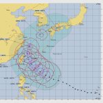
The strong El Niño pattern continues to generate oceanic and atmospheric conditions that force powerful tropical cyclone (hurricane and typhoon) development over the Pacific Ocean.
Typhoon Champi, located in the Philippine Sea of the Western Pacific Ocean, remains a “super” typhoon, similar in status and intensity to a “major” hurricane. Maximum sustained wind was 150 knots and a forecast track toward Taiwan, as analyzed by the Joint Typhoon Warning Center (JTWC).
Unlike the civilian, NOAA/NWS National Hurricane Center agency, the JTWC is a U.S. Navy and Air Force joint military command based in Pearl Harbor, Hawaii. While NOAA and the JTWC collaborate and share data, the JTWC is responsible for issuing tropical cyclone warnings in the northwest and south Pacific Ocean, and Indian Ocean.

For those attending the General Session today @nwas in Omaha, @climavision will be discussing their collaboration with the @NWS and partners bringing a suite of radar data for NWS forecasters in support of emergency managers, media and other decision-makers in the business of public safety. #NWAS26

How can gap-filling radar strengthen operational #weather coverage? That’s on the agenda at the @nwas National Weather Association #NWAS26 conference in Omaha this week! 📡 ⛈️
Today, Tuesday, October 20, Climavision’s Apoorva Bajaj will present during the 11 a.m. to Noon Central Time General Session, Flood and Radar, VORTEX-USA: “Gap-filling Weather Radar Network in the United States - Usage Within NOAA and NWS Operations”.
The focus: X-band dual-polarization Doppler radar and its lowest elevation scans — providing additional low-level observations to supplement the public radar network and support NOAA/NWS operations.
Join us for a closer look at public-private collaboration in action and be sure and say hello to Apoorva!


Power outage data visualization with past hurricane landfalls.

Brian LaMarre retweeted

🌀Hurricane Isaias Damage Analysis (1/4)
NWS Mobile continues to investigate an extreme corridor of damaging winds WEST of Isaias' center. This radar/velocity loop shows intense winds, with deeper blues/greens indicating higher wind speeds, possibly associated with a "sting jet"
A gusty northeast wind prevails across much of Florida this Sunday afternoon. Lower than normal water levels for the low tide cycle this afternoon, as water drains from the upper portion of Hillsborough Bay into Tampa Bay viewed from Bayshore Blvd in Tampa, Florida. #flwx
Refreshing across the Tampa Bay region and much of Florida early this Sun morning. 8 AM ET temperature and dew point are 10 to 15 and up to 20 degrees cooler and drier than this time yesterday thanks to the cold front. Fall-like weather can be expected all next week! #flwx

The drier air, shown by the lower dew point temperatures and sharp gradient in the precipitable water (PWAT) analysis, is slowly pushing southward across Florida. 11 AM ET temperatures range from the mid 80s and dew points in the mid 70s over South Florida to the low 60s temps and near 40 dew points over northwest Florida. #flwx


Checkout those 8 AM ET temperatures and dew points across the country this Saturday morning! A cold front is pushing south across Florida and after isolated showers and thunderstorms the first half of the day, the drier air will usher in along with a gusty north and northeast wind. Note the dew point temperatures in the 40s over the Florida Panhandle while 70s prevail across the remainder of the state.
The gusty northeast wind will also generate lower water levels in Tampa Bay - more noticeable during the lower tide cycle later today through Sunday and even into next week.
Normal afternoon high/morning low temperature for central Florida is around 85F/70F for this time of year and we will be below this through the weekend and all of next week! #flwx


It was great to participate in a special Integrated Warning Team (IWT) meeting Thursday at Tampa International Airport @FlyTPA, hosted by the National Weather Service Tampa Bay Area Weather Forecast Office @NWSTampaBay. #flwx
While these gatherings typically take place in April ahead of hurricane season, this meeting brought together local media, emergency managers, and NOAA officials to discuss potential winter weather impacts associated with a strong #ElNiño pattern and lessons from historical events across our area.
The team also demonstrated NWS flood inundation mapping services, highlighting how the guidance can support public-safety decisions and help keep communities informed during flooding.
Well done to the NWS team for bringing everyone together and sharing the presentation briefing. It was great spending time and meeting with new and familiar friends and colleagues across the weather and emergency management community - all focused on strengthening public preparedness.
Briefing slides included in comments.


Evening view of a cumulonimbus cloud associated with a thunderstorm 30 miles away in southern Polk County as viewed from Peter O. Knight airport on Davis Islands in Tampa, Florida. A military aircraft can be seen (zoom) on approach to MacDill AFB. #flwx

Brian LaMarre retweeted

Very glad our work on WeatherNext Cyclones (WN-C) at @GoogleDeepMind and @GoogleResearch proved useful for forecasting Hurricane Isaias. We were also pleased to see WN-C’s 1,000 member ensemble being used by meteorologists to help assess the full range of possibilities for Isaias’s track and intensity. Such large ensembles are one of the benefits of ML weather models, which are more efficient than traditional physics models.
There was debate among meteorologists whether wind shear and dry air would prevent Isaias from rapidly intensifying. WN-C predicted a more easterly path away from these weakening factors, with a >50% chance of a major hurricane from Oct 6th onwards, which steadily grew in confidence until Isaias eventually did reach Category 3 status three days later on Oct 9th, shortly before landfall.
Our paper on the front cover of @Nature last month evaluated WN-C against the leading physics models across more than 200 tropical cyclones globally from 2023-2025. We found that WN-C achieves ~1 day of additional useful lead time for cyclone track and intensity (an advance that typically took a decade to achieve). Getting both track and intensity right proved crucial for predicting the true threat of Isaias, and though this was just N=1 tropical cyclone, it’s great to see our breakthrough helping to protect lives and livelihoods in an operational setting.
Read the paper here: nature.com/articles/s41586-0…


Last week, Hurricane Isaias made landfall in the Florida Panhandle. Our thoughts are with everyone affected and with the recovery efforts still underway. Earlier and more accurate forecasting can help protect communities by giving them more time to prepare, and we are grateful that Google’s WeatherNext model was able to assist the @NWSNHC 's expert forecasters.
Based on initial evaluations, here's how our model supported the response to #Isaias:
- Tracking the Hurricane’s Path: WeatherNext was the most accurate model on the storm’s track. While traditional physics models predicted landfall closer to New Orleans, WeatherNext correctly predicted a path further east. This allowed NHC forecasters to highlight the potential for wind and storm surge impacts in the Florida Panhandle from their very first forecast.
- More Time to Prepare: Up to three days before landfall, our model consistently predicted its eventual location in the Florida Panhandle to within 60 km or less, supporting the NHC as they honed in on a track toward the Florida Panhandle and issued hurricane watches and warnings to give officials in Florida, Alabama, and Mississippi more time to prepare.
- Early Indications about Intensity: Early on, WeatherNext accurately predicted the intensification to a major hurricane. Alongside the regional hurricane models HWRF and HMON, WeatherNext’s intensity forecasts helped NHC forecasters to predict that the Isaias would approach the coast as a category 2 hurricane from the very first advisory.
Giving communities more time and more accurate warnings is critical for protecting lives and livelihoods. While model performance varies from storm to storm, Isaias reflects our broader findings. In our recent @Nature paper co-authored with NHC forecasters, evaluating 200+ global tropical cyclones, we found our model provides ~1 day of additional lead time for both track and intensity.
It’s been an honor for the @GoogleDeepMind and @GoogleResearch teams to work alongside NHC forecasters. By combining AI, physics models, satellite data, and the crucial expertise of meteorologists, we're excited to keep pushing the boundaries of forecasting to help protect communities.