Pinned Tweet
"Symmetry is what this kind of mapping aims for: not mapping in a way such that the map is symmetrical to the world, but in a way that the map is symmetrical to what humans know about the world."
#gischat #eochat #AugmentedReality #geodata
worldbuilder.substack.com/p/…
Christopher Beddow retweeted
Knochenarbeit am Steilhang: Oberhalb des Seealpsees im #Alpstein werden nach dem Felsabbruch im September derzeit letzte lose Felsblöcke entfernt. Der Grossteil des Gerölls wurde bereits im September weggeräumt. Heute soll der Einsatz abgeschlossen werden.

ALT Mehrere Einsatzkräfte des Zivilschutzes arbeiten an einem steilen, grasbewachsenen und mit Steinen durchsetzten Berghang im Alpstein. Sie tragen graugrüne Uniformen, einige orangefarbene Oberteile, und sind über den Hang verteilt. Mehrere Männer bücken sich oder knien, um Steine und Geröll von Hand wegzuräumen. Links fällt der Hang steil zu einem Tal ab, das von einer dichten, weissen Nebeldecke ausgefüllt ist. Im Hintergrund ragen die markanten, teils felsigen und schroff gezackten Gipfel des Alpsteins in den blauen Himmel. Rechts erhebt sich eine mächtige, steile Felswand.
Watersheds? I wouldn't what areas an exception though. Maybe a few.
Christopher Beddow retweeted
How far can you travel by train in 8h?
An isochrone map shows you where you can go by rail from any station in Europe.
Christopher Beddow retweeted
最近、授業のたびに学生の理解が進むように教育用ウェブアプリを作りまくっている。
これはラスタ標高データの基礎を学ぶためのDEM可視化ツール。5x5, 7x7, 9x9 のみに限定していて、学生たちは地理院地図ベクタの等高線を目視判読して1kmメッシュDEMを手作業で作成し、CSVファイルをこのMeshPeakに読み込ませて、手作りしたDEMをかっこよくみせるツール。
furuhashilab.github.io/MeshP…
#DEM #MeshPeak #FuruhashiLab #古橋研究室 #AoyamaGSC #地球社会共生学部 #空間情報を学ぶなら青学
Geography is destiny?
「なぜ都市の東側は西側より貧しくなりやすいのか?」という謎に向き合った研究が非常に興味深かった。
原因の一つとされるのが、「偏西風」。産業革命期、工場から排出された煙が西から東へ流れたことで、東側の住環境が悪化し、低所得層が集まるようになったという。
イングランドの70都市を対象に、19世紀の工場の立地や風向きを復元したところ、歴史的な大気汚染の影響が100年以上経った現代の居住者の社会経済的な分布にまで残っていることが明らかに。
都市の格差が、偏西風に規定されているという考え方は面白い…。
出典:Heblich et al. (2021), East-Side Story: Historical Pollution and Persistent Neighborhood Sorting, Journal of Political Economy.
doi.org/10.1086/713101
Christopher Beddow retweeted
QGIS: No AI contributions permitted github.com/qgis/QGIS-Enhance…
Christopher Beddow retweeted
I made an interactive map of every farm field in California! Inspired by the @Snapchat map!
All 384k of them: lettuce in Salinas 🥬, cherries in Brentwood 🍒, dates in Coachella 🌴, and 1.6 million acres of almonds 🌰 Zoom into any field and see exactly what's growing there.
I've been obsessed with maps from years of hiking and cycling. Models like Opus 5.5 / Astra making building with them so fun!
Built on public crop data from @CA_DWR.
Click to see growing near you? 👇
Christopher Beddow retweeted
Opus 5.5 mapped the entire coast to coast route across the USA for a clicker game I'm playing with.
5,285 km of real road, sampled every 10m from OpenStreetMap.
More Norway thoughts
- people seem to live in cool single family homes
- locals seem to use cars a lot. Many electric but surprisingly many Chevy etc trucks too
- climate more moderate than I thought
- even at sea level, seems like alpine/tundra climate zone
Back from Norway 🇳🇴
Beautiful landscapes, I like that there are more evergreen trees
Returning to 🇨🇭, it now feels reasonably priced vs 🇳🇴
Will go back again to see deeper wilds.
Conclusion: you truly want to rent a car to see 🇳🇴 properly. Transit is nice but limited.
Christopher Beddow retweeted
Bienvenidos a Pridnestrovia! (también llamada Transnistria)
Aprovechen que andaré hoy y mañana en Bender y Tiraspol por si tienen curiosidad de este país y que yo les pueda resolver.
Christopher Beddow retweeted
建物形状作成アプリの続き。
道路に沿って起点と終点を指定してやると #PLATEAU 建物の連続立面図を作成する機能を(粗々ですが)実装。
動画の1例目は京都市の祇園新橋。2例目東京都港区の新橋駅付近(しんばし繋がりなのは偶然)。
今後、各地で精度の良いLOD3が整備されていくと有用になるかも。
This is some very fun map UI
【新作アプリ✈️】
世界中の(ほぼ)全ての空港の、就航都市を3Dで可視化するサイトを作りました
→ skyto.ai
さらに、独自の航空券検索システムで、Skyscannerで探せなかった、
掘り出し物チケットが見つかります!
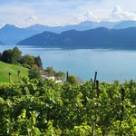
Sunset on the Vierwaldstättersee