

Hardcore hurricane chaser. Mississippi transplant. Harvard man. Righteous Bay Rat. The #HurricaneMan. Jamaican name: Mawgaman!
Bay Saint Louis, Mississippi
Joined October 2008
- Tweets64.3K
- Following2.8K
- Followers233K
- Likes143K


Pinned Tweet
ICYMI: Behold mighty #MELISSA in #Jamaica. High-end Category 5. Possibly the most intense #hurricane to make landfall in North America. And the fiercest of all the hurricanes I've witnessed. WATCH: youtu.be/siq-DdmBUIY

Gorgeous. Overwhelmed by the structural perfection. So hawt. #JOSEPHINE


As others have pointed out (like @EarthUncutTV), there've been several recent battles between "traditional" physical models & AI models—& AI models have been mostly winning. Here's a new one: Euro ENS & HRES (orange/yellow) plow Super #Typhoon #CHAMPI into Taiwan; Google DeepMind (blue) recurves it into Japan. This is strong bifurcation: there'll be a winner & a loser.


Cat-1 #Hurricane #TRUDY will scrape along the Colima & Jalisco coasts today & tomorrow. While core is modeled to stay offshore, coastal locations could get rough conditions. There's a Hurricane Warning from Manzanillo to Cabo Corrientes. Be ready in case TRUDY deviates to the E.


I just scolded my trusty ChatGPT assistant for not laughing at a sassy joke I made. Let's just say he got the message and got a new attitude.
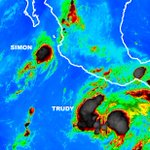
Two cyclones threaten #Mexico tonight:
* #Hurricane #SIMON has reintensified, but it's tiny: hurricane winds extend only 10 mi from center! Models are all over the place. Hard to say where it's going.
* TS #TRUDY is strengthening off S coast. It'll become intense hurricane & may threaten Colima or Jalisco late in the week. Getting tingles from this one.

Tiny Cat-1 #Hurricane #SIMON lingers off #Mexico. Future highly uncertain. Computer models show "squashed spider" pattern, with potential tracks in many directions—from out to sea to Los Cabos to Sinaloa. It'll be on weather map for days. Real problem may be next one: #TRUDY.

Foggy morning at Hurricane House. Can't even see the Gulf from the front lawn; the street just disappears into the grey. Ready for another expedition, but no clear candidates at the moment.


#Hurricane #SIMON has weakened to Cat 3 as it continues spinning just offshore of #Mexico. Been getting lots of questions from Puerto Vallarta & Mazatlan, so this post is for my good friends in those cities:
* PUERTO VALLARTA: You're still under Hurricane Warning. But many of you are puzzled about why it's been so calm and quiet overnight. The hurricane is very small, so you have to be close to it to feel it. And, it's slowly bending *away* from Puerto Vallarta. I feel fairly confident its dangerous core will stay far from city. But you may get occasional storminess as well as rough surf & coastal flooding for next couple of days. Take precautions.
* MAZATLAN: Trouble may be coming. You're under Hurricane Watch. Latest NHC forecast brings SIMON ashore as Cat 1 near city on Wednesday. But, this forecast is uncertain. Models are wild tangle—showing many possibilities—so we can't assume anything. For now, just be ready.

Poor #Hurricane #SIMON. Looks like trash tonight. I'd like to celebrate it staying offshore & sparing Jalisco its maximum power. I'd also like to celebrate my resisting public pressure & not getting suckered into chasing it. Doubters—when ya gonna learn? Chaserdude knows best.😎

#ISAIAS was my 88th #hurricane core penetration. It wasn't the prettiest specimen—it was kind of a freak show, honestly—but it had some spicy moments, & I got some real purdy shots thanks to dramatic views & great lighting. Now deciding which lucky cyclone will be No. 89.❤️


While chasing #Hurricane #ISAIAS, I realized why I feel so at home going through the car wash.
Center of Cat 4 #Hurricane #SIMON is ~20 mi offshore as it moves parallel to Jalisco coast. Looks to me like narrow core is staying just offshore—for now, at least. Storm is also weakening, likely due to land interaction. Winds are down to 120 knots & eye is filling. But cities that got spared—like Manzanillo—are experiencing heavy rain & damaging surf. Upcoming impacts to Puerto Vallarta are highly dependent on small nuances in the track. Stay tuned.

Intense #Hurricane #SIMON is just off the Jalisco coast of #Mexico with winds of 135 knots. If I were there I'd be tearing my hair out, because this is the worst kind of chase: tiny core moving parallel to the coastline with rough terrain & few towns or paved roads. It's tough to hunt down & penetrate the center with this kind of setup—especially without radar. Hopefully for residents, SIMON's intense core stays just offshore.

The sky was giving mega-autumnal vibes this evening as I headed back home to Mississippi after chasing #Hurricane #ISAIAS. Was it the colors? Or the freshness of the air? Funny that some computer models are hinting at more Gulf mischief later this month...
