

Clinton, Utah
Joined October 2021
- Tweets11K
- Following335
- Followers305
- Likes86K





Pinned Tweet
A portion of used water making it to the #GreatSaltLake is better than no water making it to the lake because of water conservation.
Residential returns 50 to 90% of its used water.
Agriculture returns 30 to 50% of its used water.
I looked at the unreadable Solitude snow stake and judged by the sticker that it was around 16", so, I checked Alta to see if it was comparable.
Damn, this storm over performed! 👏👏👏
(The Solitude stake is still good for viewing how hard it is coming down)

2
1
22


Holy smokes! Already up 5" since I posted. 6" now🥳🥳🥳

Track the snow falling, an inch thus far!
youtube.com/watch?v=lkEM6EC8…
2
54


Short-term multi-indicator drought index.
Image 1: this week
Image 2: last week
Still drought free
Expect the blues to return because of current storms.


2
258
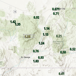
SW Utah 24 hr. precipitation accumulation.
St George to Lake Mead drainage seeing over an inch of water input.
My USDA SNOTEL link is not working, but I suspect this will put the area over 50% of an annual water year precipitation in the 1st, 2 months of the year! Record 💦

8
417
GSL Sentinel retweeted

Snowbird's 15.7 inches of water since the start of the water year (Oct 1) is the most ever on this date! Yet, we are only at 67% snowpack. Not to beat a wet and warm horse, but that's a crazy statistic.


Track the snow falling, an inch thus far!
youtube.com/watch?v=lkEM6EC8…

Pretty sure these guys wouldn't see water if they were standing in the middle of Utah Lake.
Utah has had 5 months of above average precipitation.
Oct. was not just wet, it was extraordinary.
5 months does erase drought.
Drought monitor lags by months.

1
2
318
Currently Utah is 209% of normal precipitation.
Their own reservoirs have risen around 5% at a time of year they are usually in decline.
1
70


