

Ugandan. Creating & Using (open) geography data and technology to understand our planet better.
Afrika
Joined September 2009
- Tweets658
- Following212
- Followers296
- Likes848





Asking for an engineer on my team! There's mutual interest on the topic 🧵
Is there an R/Python library that maps ground features of one unique location onto another unique location?
#rstats #r #rshiny #python #geopandas #numpy #machinelearning
For context, we have a typical machine learning workflow with training data from one country and we'd like to map that data or the features in that data to any other location in the world.
Nice thread 🔥
Fascinated by "Changes on our planet" and to that effect, currently working with an amazing team to explore long-term changes on earth with a focus on Land.
Work with Open and reproducible workflows for most of my(our) work.

Day 6 - Red of the #30daymapchallenge
City Roads - With a Focus on Kampala, Uganda's Capital.
Data from @openstreetmap @UNRA_UG


Day 1 - Points of the #30daymapchallenge
🔥 🔥 🔥
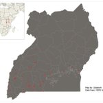
Live fires detected in the East African nation of Uganda over the last six months.
Anyone know why the Western part of Uganda seems to be burning more compared to the rest of the country?
Cattle feed 'biz' perhaps?
#gischat

kadoch retweeted

Submit your abstract today! Choose between academic papers, main conference, workshops and lastly our maps and posters section. #FOSS4G 2018.foss4g.org/programme.ht… #osgeo #Tanzania
kadoch retweeted

Get ready for #foss4g2018! Academic Track call for contributions is open! #Geo4All lists.osgeo.org/pipermail/ge… 2018.foss4g.org/call-for-pap… #OSGeo


kadoch retweeted
#sotmafrica attendees getting some hands-on training using #OSM data in #GIS, #webmapping, and free SDI

kadoch retweeted
Stephen Mather talking about Point Cloud in your pocket: Scaling Open Source Photogrammetry #sotmafrica Day2


kadoch retweeted
Wow! We're happy to see so many mappers at the first State of the Map Africa! #sotmafrica

kadoch retweeted
Severin Menard shares with us how #OSM communities are growing in West Africa at #sotmafrica.

Hey @joshculture @mapkibera thanks for your talk at #sotmafrica will you 'smuggle' me back with you ;)...xitter.cf/kadoch/status/88365120…

kadoch retweeted
"When women rise, mountains move"- Women in Tech and Mapping at #sotmafrica @maintainch @Honorable_Nath @AngieNicoleOD @jachapman82 @falher3

Checking into #sotmafrica for 3 days of mappy action. Totally love my name tag @mapuganda ;)

kadoch retweeted
The #sotmafrica program will be out soon! Until then, keep an eye out for program previews highlighting our scheduled talks.