

Professor of Coastal Engineering @ University of Southern California #tsunami
Univ of Southern California
Joined August 2022
- Tweets65
- Following99
- Followers145
- Likes293






Patrick Lynett retweeted

Hurricane Marie delivered incredible swell for surfers in Southern California over the Labor Day weekend, but the gift of great waves was double-edged. The large surf caused severe beach erosion and coastal flooding that impacted beaches from Long Beach to Encinitas and beyond — damaging or destroying boardwalks and staircases, flooding homes, and exposing long-buried infrastructure, like the pilings of an old pier in Newport Beach.
At Surfrider, it’s no secret that we love our beaches. That’s why we are devastated when these major erosion events occur. But it’s important for communities to remain level-headed about how they respond… especially with a very strong El Niño season just getting underway, and many more extreme swell and beach erosion events to come this winter.
Our biggest priority must be to protect the future of our beaches. Not just for next summer, but for the next generation to enjoy. How we choose to respond now will have significant implications on what that future looks like for our coasts. Coastal armoring, such as seawalls and rock revetments, can at best buy a little time for private property and infrastructure; but the true price is paid in diminished access, accelerated erosion, and lost resilience. That’s why planning for how we adapt our coasts, applying nature-based solutions, and engaging communities in these efforts are so critically important before conditions become dire.
Learn more about Surfrider’s work to protect and adapt our coasts, and to find out how you can get involved here: hubs.la/Q04xb9dQ0
Video Credit: Long Beach footage by KC Fockler, Aliso Beach footage by Blair Conklin, Salt Creek Beach footage by Craig Whetter
Patrick Lynett retweeted

GRIEF LESSONS: One year ago, a massive landslide blasted a #tsunami as tall as a 30-story building down an #Alaskan fjord, ripping away 50 km of shoreline forest. I joined the first scientific survey to document the aftermath. What we saw beggared belief. outofedenwalk.nationalgeogra…
Patrick Lynett retweeted

C’è stato il secondo tsunami più grande della storia con un’onda alta quasi 500 metri (e nessuno se ne è accorto) trib.al/vJoNbty
Patrick Lynett retweeted

Gelombang megatsunami dahsyat yang terbentuk ketika gunung es di Alaska runtuh ke laut pada 2025 adalah tsunami tertinggi kedua yang pernah tercatat (hampir 500 meter).
Gelombang ini jadi pengingat akan risiko yang ditimbulkan oleh mencairnya gletser.
Patrick Lynett retweeted

"Onda chega aos 481 metros de altura, mais alta do que o Empire State Building": o que explica o mega-tsunami no Alasca? sicnoticias.pt/meteorologia/…

Patrick Lynett retweeted

Engineer creates video game of Alaska’s Tracy Arm landslide, which generated a megatsunami 👉 tinyurl.com/3xd39euf?utm_sou…

Patrick Lynett retweeted

More on the Tracy Arm megatsunami, published in Science on May 6.
science.org/doi/10.1126/scie…

Patrick Lynett retweeted
The 2nd largest tsunami ever recorded struck Alaska's Tracy Arm Fjord on August 10, 2025, about 50 miles southeast of Juneau.
The wave reached a staggering 1,580 feet tall.


Ever wonder what a ~480 m (1550’) tsunami might look like? Using the tsunami hydro modeling in our paper out today in Science on the mega-landslide-tsunami in Tracy Arm, Alaska, we have created a few compelling animations that you might enjoy.
Paper: science.org/doi/10.1126/scie…
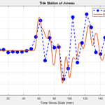
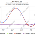
Another huge landslide and tsunami in coastal Alaska yesterday morning. Still a bit of a puzzle, but working with the @AKearthquake source location, the timing of waves from eyewitnesses on Harvest Island and in Endicott Arm, and the @NOAA Juneau tide gage recording, it appears that a massive slide occurred ~5 km east of the end of Tracy Arm. With this info guiding simulations, a plausible/likely scenario (there are others!) is that the slide ran down Sawyer Glacier, impacted into the water at the end of Tracy Arm, and displaced somewhere between 100-200 million cubic meters of water. A simulation with this info matches eyewitness tsunami observations and the tide gauge, shown below. Animation here as well. If this source pans out (the slide location is still uncertain – need satellite imagery to confirm), there were likely *very* large waves within ~5 km of the slide-water impact location at the end of Tracy Arm.

Happened to be in Corvallis for a meeting, decided to drive down to Crescent City to document the tsunami in the harbor. Made it there just before midnight last night and stayed into the morning. Many surges like that shown in the video below, which was taken a bit before 7 AM.


busy few days... For the wave nerds, check out the tide gage in Santa Barbara Harbor last Thurs afternoon during the first swell. 1+m crest-to-trough harbor sloshing at low tide. Similar wave height as the Hunga Tonga tsunami of 2022. Likely the... #cawx #waves #SantaBarbara

Patrick Lynett retweeted

Significant tsunami waves appear to be incoming (peak to peak waveheight of 1.5 m) at Toyama sea level station due to M7.5 earthquake near west coast of Japan

#HermosaBeach 83'. One of the reasons the City now builds a winter berm in front of the plaza.

#TBT To the El Nino winter of 1982/83 one of the largest and most destructive on record. The intensity of the swell coupled with the high tide brought the waterline all the way up the beach and across the bike path causing massive areas of flooding and beach erosion.


Patrick Lynett retweeted

To celebrate #TsunamiDay, visitors at @UN headquarters in NY experienced a unique 3-min virtual reality tsunami drill to learn vital information on how to stay safe during a tsunami. 👉 ow.ly/Rn8350Q5ojR #GetToHighGround


Patrick Lynett retweeted
Join us at the @UN General Assembly building today in New York for a unique experience! Learn about tsunami preparedness with a 3-min virtual reality drill.
Learn crucial safety measures! @MofaJapan_en @JapanMissionUN #TsunamiDay

