

When in doubt, chase for clout.
Jonesboro, AR
Joined August 2020
- Tweets17.4K
- Following336
- Followers1.8K
- Likes18.1K





Pinned Tweet
Horrible damage in Rolling Fork, MS. Branches stripped of bark, cars thrown onto buildings, and brick structures demolished. This is the strongest tornado damage ive personally seen. From what I understand, there are many casualties, too.


Meteoroloquads retweeted

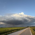
Just an amazing supercell approaching Show Low right now. #azwx @NWSFlagstaff

Quite the minisupercell on the Flagstaff radar at the moment. An oddity for both this region AND this time of year…


May 29, 2025
This unbelievably low-topped supercell in eastern Arkansas managed to produce THREE tornadoes in its lifetime with the help of low-level thermodynamics, with one ongoing in this photo.


Meteoroloquads retweeted

There are some absolutely nasty mesovortices in the eye of Typhoon Champi.
It's not unreasonable to assume that there are some short-lived tornado-like vortices spinning around in association with them.

Dangerous near-Super Typhoon Champi forecast to graze Guam with its northern eyewall within the next couple hours.


Meteoroloquads retweeted

As we head into November, we should begin to see more of El Nino's influence on our weather pattern across North America.
A strong subtropical jet (more noticeable at 300/200mb) will set up across the Southern tier of the U.S., providing a more active, and cooler (yet still generally mild) pattern.

