

Real Estate Research Designed for Kenya @ https://teapawt.org/t.co/SQDc1GAJEP
Nairobi, Kenya
Joined July 2022
- Tweets492
- Following498
- Followers1.5K
- Likes3.1K




Winners and losers in today's Supreme Court ruling on the Rhapta Road high-rise developments:
✅ Residents: Won their argument that Nairobi County unlawfully relied on the unapproved 2021 zoning policy to grant development approvals.
✅ Developers: Avoided demolition orders, and their NEMA environmental licences remain valid.
❌ Nairobi County: Found to have failed in its constitutional duty to establish a lawful planning framework.
❌ 20-floor limit: The court rejected the judiciary's authority to set building heights or determine zoning classifications.
What's next? The Court of Appeal will review whether Nairobi's new 2026 Development Control Policy satisfies the court's requirements.
You can explore Nairobi's 2026 zoning boundaries on the Plotwise map to see how different areas are classified and the development controls that apply to each zone:
plotwise.co/map


Link to the Judgements, Rulings and media Summaries delivered by the Supreme Court of Kenya on Friday 30/10/2026. drive.google.com/drive/folde…
You can access all our decisions from our Website: supremecourt.judiciary.go.ke
Judgement in:
2) SCPT/E044/2025 Claire Kubochi & 2 Others Suing as the Officials of Rhapta Road Residents Association Vs CECM Built Environment & Urban Planning, Nairobi City County & 20 Others
With all the recent scrutiny over tree felling, @KeForestService could probably make life a lot easier for itself by being more proactive with public information.
For starters, publishing detailed, publicly accessible maps of forest boundaries would help Kenyans understand where forests begin and end, and even help the public identify illegal tree felling or encroachment.
Secondly, for planned harvesting, clearing or replanting activities, KFS could publish advance notices showing the exact areas on a map, along with details of the work being carried out.
Making the underlying GIS data openly available would be even better, allowing the mapping community to help improve the data and build useful tools around it.
This could help KFS avoid unnecessary controversy, build public trust and involve more Kenyans in protecting our forests.
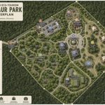
A dinosaur theme park is being proposed inside Oloolua Forest, near Ngong, Kajiado County 🦕
The development will cover approximately 7.63 acres and include robotic dinosaur exhibits, elevated nature trails, five eco-cottages, a restaurant, museum and picnic areas.
The project has received a special use licence from the Kenya Forest Service, although NEMA environmental approval has not yet been confirmed.
Keep up with proposed developments and other major changes happening across Kenya on Plotwise Community.
plotwise.co/community


It's a strange one. Governor Sakaja himself said the project was never approved. My guess is that's why it wasn't in the database to begin with. It's possible they only added it yesterday. Whether we'll ever get to the bottom of what actually happened remains to be seen.
Plotwise retweeted

Dear @ncakenya
I verify data for a living. So I checked your own portal.
Project No. 53128815710410: not there.
Stromax Holdings E.A Limited not there.
Either your portal is wrong or your press statement is. Both came from you.
Records don't lie. Let's see if you do!


The NCA says the collapsed Eastleigh building was registered under number 53128815710410.
We decided to check its official database, but the registration number was nowhere to be found.
nca.go.ke/approved-projects

UPDATE: NCA added the project to its database today. However, the listing appears to contradict Governor Sakaja’s statement that the project had not received approval.
Governor Sakaja has confirmed that the collapsed Eastleigh building was under construction without the required approvals.
Plotwise retweeted

Nairobi Governor Johnson Sakaja says the multi-storey building that collapsed along 9th Street in Eastleigh was under construction without the required approvals, despite an application for a 15-storey building with a basement having been submitted.
Sakaja says the county has forwarded documentation to the DCI for investigations and called for accountability among the developer and professionals involved, including the architect and engineer on record.
That registration number does not appear in your database of approved projects: nca.go.ke/approved-projects

The tragic incident in Eastleigh, where a multi-storey building under construction collapsed this afternoon, happened along 9th Street:
plotwise.co/map?id=31d590e3-…
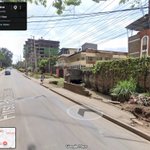
The image on the left is an older Street View capture showing the stalls that previously occupied the plot. The image on the right shows the aftermath of the collapse, including significant damage to the neighbouring building.


Yes, it would be great if @nairobi_rivers could publish accurate digital maps of these waterways.
It's unclear when the specific canal in the photo was built, but it may date back to the colonial period. Interestingly, historical survey records referenced in a court case show that the canal near Oshwal Religious Centre existed as far back as 1934, when it was described as a "canalized stream".
The sharp angles aren't necessarily accurate. The line shows the general path of the canal, using data from OpenStreetMap. Some sections may be simplified, so bends and turns can appear sharper than they actually are on the ground.
For example, where the canal meets First Parklands Avenue, the map shows a sharp 90-degree turn, but the canal doesn't actually turn at a right angle.
maps.app.goo.gl/u1UfGtm2EUxp…

