

GIS, Interactive & Printed Trail Maps, Data Books, Trip Planners, Snow, Wildfires, Gear Lists, Open Source. Portfolio: https://xitter.cf/t.co/tARZ3syM4P
Crescent City, California, USA
Joined April 2009
- Tweets2K
- Following188
- Followers787
- Likes3K


Postholer - GIS Resources retweeted

Phosphor now supports qualitative palettes. It includes my own presets that are mathematically designed to maximize visual differentiation, as well as common palettes from ColorBrewer and Tableau.
And each is editable, shareable, and exportable.

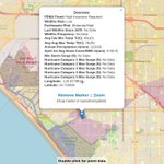
Monitor water year and month-to-date precipitation as the winter unfolds on an interactive map. Updates daily.
Will #ElNino impacts be hype or reality? Follow along:
femafhz.com/map/37.727701/-1…
You can see intense tropical storm moisture impact in the image.
#NCEP

Just updated our land cover/fire recovery charts (added 2024/2025) for 26 trails:

As a side note, charting land cover change in fire recovery areas. Example, 2009 Station Fire 67% evergreen cover to 0%, with almost no recovery in 16 years, along linear feature #PacificCrestTrail. Grasses, then shrubs dominate:
postholer.com/map/Pacific-Cr…
Available for 26 trails.


All those saps that bought into the DuckDB hype, who are now dependent on it, get to pay Amazon for the privilege.

AWS to acquire DuckLabs, the Amsterdam-based company behind DuckDB aboutamazon.com/news/company…


Postholer - GIS Resources retweeted

420 km of optical fiber now links two entangled quantum memories, more than four times the previous memory-based record, using atom clouds that never physically touch. @physrevlett @arxiv phys.org/news/2026-08-physic…

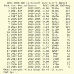
El Nino/La Nina snow impact on the sierra in California for DJF and JFM periods, 2004-26. Avg based on Apr 1.
The top 10 snow years averaged -0.28 or mild Nina. The biggest snow year, 22-23, was -0.86 mild/moderate Nina.
@WeatherProf @Weather_West #ElNino #SNODAS #ggweather


As of this morning, Oregon is scorching the way for wildfires this season (so far). Utah is a very distant second:
#wildfires #oregon @US_Stormwatch @Weather_West

The following creates a spatially indexed @flatgeobuf (FGB) of @USGSLandsat ARD #metadata by polygon. It accesses over 2.3 million rows (currently). 1982 to present. It is blazing fast and does not require an API or complex client stack.
postholer.com/portfolio/note…
#GIS

Tropical storm Elida and sea surface temps:
femafhz.com/map/27.916767/-1…
Change the layer to sea surface anomaly to visualize how temps are compared to normal. Sea surface temps are actually below normal for a large swath near the California coast.
@US_Stormwatch

Create a median composite raster from Sentinel-2 using only @GdalOrg
This tutorial achieves the same result as @spatialthoughts Python tutorial, using only GDAL and Bash, without Python and it's dependencies.
postholer.com/portfolio/note…

ALT Sentinel-2 median composite raster of Bengaluru, IN.


Postholer - GIS Resources retweeted

A shake-powered capsule inactivated 99.9999% of bacteria and viruses in up to 4 liters of water, while also checking conductivity to judge whether disinfection should begin. techxplore.com/news/2026-06-…

Since El Nino was officially declared today, here's a ZERO hype reminder of how little it impacts Sierra Nevada snow pack in California over the last 23 years. In fact, La Nina clearly has a greater impact.
@BenNollWeather @WeatherProf @Weather_West @RyanWeather
More evidence against El Nino hype.
Looking at the last 22 years, there's no evidence strong/moderate El Nino contributes to wetter weather. Only 2 of the top 10 years were moderate. 6 were Nina's!!!
The opposite seems to be true in a changing climate.
bsky.app/profile/postholer.c…


Our trail fires page is ready for the upcoming fire season. We've added video that shows smoke, hotspots, burn scars and fire weather index over the last 72 hours, in 1 hour increments. Choose your trail.
postholer.com/trail-fires

More evidence against El Nino hype.
Looking at the last 22 years, there's no evidence strong/moderate El Nino contributes to wetter weather. Only 2 of the top 10 years were moderate. 6 were Nina's!!!
The opposite seems to be true in a changing climate.
bsky.app/profile/postholer.c…