

One Life One Chance. Loves Rain than everything else. Tweets on cricket, chess and anything, etc.
Chennai, India
Joined October 2014
- Tweets16.5K
- Following431
- Followers571K
- Likes2.6K






Pinned Tweet
Northeast Monsoon (NEM) rainfall not exactly an outlook, just a glimpse what can be expected in 2026.
-----------------------
El Niño is an important factor, but it does not determine the outcome of the Northeast Monsoon. The monsoon has its own way of unfolding, often throwing surprises and reminding us that every season has a story of its own
For reference, the seasonal NEM rainfall normal is 855 mm for Chennai and 445 mm for Tamil Nadu. Interestingly, historical comparisons suggest that around 85–90% of El Niño years have recorded above normal NEM rainfall. This is a historical tendency, not a guarantee of what any particular year will deliver.
A look back at some remarkable years
-------------
2015: Chennai recorded around 1,664 mm during the Northeast Monsoon, a season remembered for its catastrophic floods.
1997: Tamil Nadu recorded around 810 mm, setting a remarkable rainfall record that surpassed the previous benchmark from 1946.
1982: A contrasting year, with significant rainfall deficits across Chennai and Tamil Nadu.
One striking aspect of 1997 and 2015 is that their extraordinary rainfall outcomes were not simply a consequence of frequent cyclone activity. In particular, 1997 stands out for the scale of rainfall recorded across Tamil Nadu despite the relative lack of cyclonic activity.
What about the 2026 Northeast Monsoon?
-------------------------
The 2026 Pacific sea-surface temperature pattern shows a strong warm signal along the equatorial Pacific, consistent with El Niño conditions. However, history reminds us that we cannot assess the Northeast Monsoon by looking at El Niño alone.
The Indian Ocean Dipole (IOD) is another important player, influencing the broader ocean-atmosphere environment. And then comes the kingmaker the Madden–Julian Oscillation (MJO).
King maker MJO
--------------
The MJO's presence over our basin during the past week is encouraging and we can see the Tamil Nadu rains this october from negative to positive with MJO's help . If it remains favourable and spends a meaningful amount of time over the Indian Ocean during November, it could support active spells of convection and rainfall over Tamil Nadu. Its movement and persistence will be crucial factors to watch.
My rainfall outlook for 2026
-----------------------------
Tamil Nadu: The season has the potential to finish above normal, possibly in the 470–520 mm range, compared with the normal of 445 mm.
Chennai (KTCC): Against a normal of 855 mm, the city has received approximately 230 mm so far. The coming days could help push the seasonal total towards or beyond 300 mm, depending on how the last week Low pressure play out, if it goes to North Andhra / Odisha, we might miss crucial spells.
1. Tamil Nadu, I do not expect 2026 to match the extraordinary rainfall totals of 2015, let alone approach the 1997 benchmark of 810 mm. A finish closer to 500 mm looks like a reasonable possibility at this stage.
2. KTCC (Chennai), however, the story could be different. A few intense, well-positioned rainfall events can dramatically change the seasonal tally. Crossing 1,000 mm is possible, although it would require favourable conditions to persist and some significant rainfall spells. Reaching the exceptional levels of 1,500 mm or more recorded in years such as 2015 and 1997 would be a much bigger challenge.
3. . South Tamil Nadu — El Niño years, South TN oda attam vera level!. Districts such as Kanyakumari, Tirunelveli, Theni, Tenkasi, Virudhunagar, Thoothukudi, Madurai and Ramanathapuram can perform very well during El Niño years, with several areas having the potential to record high excess rainfall. South Tamil Nadu is one of the regions I am optimistic about this season.
4.. West Tamil Nadu — The Kongu belt's only concern. Districts such as Coimbatore, the Nilgiris and other parts of the Kongu belt depend significantly on low-pressure areas and upper-air cyclonic circulations (UACs) moving from the Bay of Bengal across the peninsula towards the Arabian Sea. These systems can bring very good rainfall to the western districts. So watchout for +IOD which can lead to more systems in Arabian sea, which can help easterlies to Kongu belt. This region remains my main area of concern. However, years such as 1997 showed that the Kongu belt can perform exceptionally well. These districts have already started October with a bang, and I expect them to do well during the October 20–24 spell. Normal to slightly above-normal rainfall is a reasonable expectation for this region.
5. Interior Tamil Nadu — Many UACs could make the difference. From Salem, Dharmapuri, Krishnagiri and Tirupattur to Vellore, Kallakurichi, Tiruvannamalai and other interior districts, rainfall often depends on the formation and movement of upper-air cyclonic circulations or weak ciruclations. Such systems are not uncommon during El Niño years. These districts, along with the Kongu belt, bore the brunt of hot spells and relatively poor rainfall during the Southwest Monsoon. However, the Northeast Monsoon offers a fresh opportunity. I expect most of these interior districts to receive normal to above-normal rainfall during NEM 2026, provided favourable circulations develop.
6. Delta and Cuddalore–Puducherry belt — The wettest zone of NEM!. From Cuddalore through the Delta districts towards Puducherry, this belt is among the most favoured regions during the Northeast Monsoon. No major surprises here I expect this region to perform very well, with the potential for at least 20% excess rainfall over the seasonal normal.
The Northeast Monsoon still has a long way to go. November, in particular, could be decisive. November forecast is looking good. As always, these are my current expectations based on the evolving climate and weather pattern, not a certainty as always NEM throws few surprises along the way and rains tell their own story.

The dry belts of Coimbatore, Tiruppur, Dindigul all got superb rains. Particularly Coimbatore and Tiruppur. More centuries will come from other Interior districts by morning. Kanykumari too seeing intense rains.
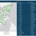
Track Live Rainfall recorded in your place through Disaster Management ARGs - beta-tnsmart.rimes.int/index…

And the cup goes to Person A from Vadakupatti
Person A: One guy predicts sorry he does nowcasts only of no rain for all 365 days. Even when it rains, he never predicts it. He is technically correct on around 300 days.
Person B: Another guy predicts rain on 60 out of 365 days. He gets those 60 days right but misses around 5 rainy days.
The winner is Person A, because he is right on 300 days vs 60 days of Person B, so winner cup ungalukku thaan vadakupatti sir !!!
I can compile all the wrong tweets you have posted, even if you have deleted them, and expose the truth. Don't make me do that.
If you love blogging, post whatever you want about the weather and let the public benefit from your insights.
But when all your posts are nothing but potshots at someone else, driven by jealousy, it reflects poorly on you. The more jealous you get, the deeper you dig your own pit.
Can you boldly predict whether it will rain or not before the event? Instead, you keep saying, “Let’s track it in real time.” Even the common public knows how to track rainfall in real time!
Once the event is over, you come forward with potshots and criticism. The real test of a weather blogger is to make a forecast before the event and not to analyse everything in hindsight.
Today to Tomorrow – We are in the Final Round of Rains from the Low dragged from the Arabian Sea towards the Bay of Bengal, against its wishes.
=============
As Cyclone Arnab strengthens, the low-pressure system over the Arabian Sea is expected to be pulled towards the Bay of Bengal side, off the North Tamil Nadu coast, by tomorrow.
We can expect easterly winds on the northern side of the circulation, from Cuddalore to Chennai. Meanwhile, southern Tamil Nadu districts such as Kumari, Nellai, Thoothukudi and Theni will experience westerly winds.
Hotspot zone
--------------
Heavy Rainfall Areas – Once again, the central interior and coastal districts, right from Villupuram to the Nilgiris, are in the hotspot for rainfall. Kallakurichi, Dharmapuri, Salem, Tiruppur, Coimbatore, Nilgiris, Erode, Namakkal, Dindigul, Karur, Trichy, Madurai, Pudukkottai and Sivaganga are all in focus. The Delta belt and adjoining districts Trichy, Thanjavur, Nagapattinam, Mayiladuthurai, Kumbakonam, Ariyalur, Perambalur, Cuddalore, Puducherry, Villupuram and Tiruvannamalai all fall within the convergence zone for heavy rains.
South TN
------------
Down south, Kumari, Nellai, Theni and Thenkasi are expected to receive an additional push from westerly winds (refer to the image).
Chennai (KTCC)
----------
Up north, the KTCC (Chennai) region, along with Ranipet and Vellore, could receive moisture from the northern side of the circulation, with winds coming in from the sea.
Today through tomorrow morning could be one final opportunity for KTCC (Chennai) to receive rains before we enter a break. Although computer weather models are not indicating much rainfall for Chennai, this particular wind pattern has brought rain to the city in the past. Let’s see how much Chennai manages to receive by tomorrow. Peak rains will be from night to mornings or mornings.
Overall, another massive rainy day is on the cards for much of Tamil Nadu. Watch out for the Kodaikanal and Coonoor belts today, as easterly winds get trapped against the hills, potentially triggering heavy rainfall.

Tamil Nadu Top 24 hrs Rainfall recorded on 8.30 am on 25.10.2026 - What a day for North Interior Tamil Nadu - Kallakuruchi, Villupuram, Cuddalore Interiors, Dharmapuri, Perambalur, Ariyalur, Tiruvannamalai, Namakkal, Salem, Krishnagiri all got their best day in this monsoon season.

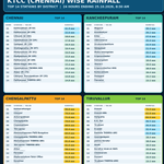
KTCC (Chennai) Top 24 hrs Rainfall recorded on 8.30 am of 25.10.2026, Chengalpet which has been missing the party has got widespread heavy rainfall.

Chennai Water Supply lakes as on 25.10.2026. Good rains in Tiruvallur and Chengalpet districts. Very heavy rains in Chengalpet district.
Tonight to tomorrow morning looks good for rains for Chennai including the central city areas.. It will be the final spell of rains before KTCC (Chennai) goes into break in rainfall.

Widespread rains in Interior Tamil Nadu for 3rd straight day. Trichy hattrick of heavy rains. Salem, Erode, Karur, Kallakuruchi, Dindigul, Tiruvannamalai,
Perambalur, Ariyalur, Interior Cuddalore all will join soon.

Tamil Nadu Weatherman retweeted

What’s the Rain Forecast for the Next Few Days? More showers ahead, or a break from the rain?
#TableTalk20 #TamilPodcast #PradeepJohn #TamilnaduWeatherman #RainForecast #WeatherUpdates #ComingSoon
🤖 Made with AI
Tamil Nadu Weatherman retweeted
How do weather forecasters know when it might rain?
#TableTalk20 #TamilPodcast #PradeepJohn #TamilnaduWeatherman #WeatherForecasting #WeatherAwareness #ComingSoon
🤖 Made with AI
PJ Interpretation of Weather Charts for the Common Man – 24.10.2026
================
1.North / North Interior Tamil Nadu
-----------------------------
Widespread rainfall is expected across the northern interior districts, with heavy to very heavy rainfall possible at isolated locations. Districts to watch: Tirupattur, Tiruvannamalai, Krishnagiri, Dharmapuri, Salem, Kallakurichi, Villupuram and Cuddalore.
Watch – Hill Areas: Yercaud, 3. Kolli Hills, Kalrayan Hills and Jawadhu Hills could receive intense rainfall.
2. Cauvery Delta and Adjoining Districts
-----------------------
Southerly winds are expected to bring moderate to heavy rainfall across parts of the Cauvery Delta and adjoining districts. Districts to watch: Thanjavur, Tiruvarur, Nagapattinam, Mayiladuthurai, Tiruchirappalli, Ariyalur, Perambalur and Pudukkottai.
3. West Tamil Nadu and Hill Districts
--------------
Districts to watch: Nilgiris, Coimbatore, Tiruppur, Erode, Karur and Namakkal. The Nilgiris and adjoining Western Ghats terrain stand out for the potential for locally heavier rainfall. Coimbatore, Tiruppur, Dindigul and Erode may also receive showers, with rainfall intensity varying considerably from place to place.
Coonoor: Hill slopes and vulnerable terrain in the Nilgiris could experience intense spells and landslides.
4. South Tamil Nadu – Kanyakumari and Nellai ghat areas
------------------------
Rain is possible around Kanyakumari and nearby southern areas. Some places in Kumari could receive heavy rain today.
5. KTCC (Chennai)
------------------
Rains are expected to pick up later at night to morning. Tomorrow looks Semma! and best day for rains Let’s see how it pans out.
Overall: North Interior Tamil Nadu and the Coonoor Nilgiris belt deserve close attention, while moderate to heavy spells are possible across parts of the Cauvery Delta.

Tamil Nadu Top 50 rainfall ending 24 hrs at 8.30 am on 24.10.2026 - Coonoor and Kotagiri belts in Nilgiris got very heavy to extreme rains.
Trichy, Erode, Dindigul, Ariyalur, Tiruvannamalai, Ariyalaur and Coimbatore also got widespread rains.

Chennai Lake position as of 24.10.2026. Next two days rain expected, the inflows are expected to increase before we go into break from October 27 to November 1.

TWM Weather Watch - CYCLONE ARNAB vs ARABIAN SEA LOW — Nature's own Prime Time Fight Night !!
=================
Bay of Bengal la irundhu Arnab entry kudukkararu! Arabian Sea la irundhu Low Pressure counter attack pannudhu!
THE FIGHT: Arnab wins the battle! He drags the Arabian Sea Low towards him and finally swallows the low pressure system.
OUTCOME: Tamil Nadu ku adutha 2–3 days semma weather action days ku irukka pogudhu. Just look at the images to understand why the next 2–3 days could be massive for Tamil Nadu!
This post is purely for educational purpose for common man to understand how two systems both sides play out.


KTCC (CHENNAI RAINFALL) UPDATE
------------------
1. Saturday Night – Sunday Morning: Rain spells expected across Chennai and surrounding areas.
2. Sunday Night – Monday Morning: The heavier spell is expected during this period,
Then we go into break in rains.
TAMIL NADU HILL STATIONS — HEAVY RAIN & POSSILE LANDSLIDE ALERT TILL TUESDAY
==================
When a low-pressure system develops over the Arabian Sea close to Kerala, watch out for the following hill stations over the next 3 days.
HIGH-RISK AREAS TO WATCH - VALLEYS that open from EAST
-------------------------
1. Coonoor belt and surrounding Nilgiris
2. Kodaikanal
3. Manjolai Hills
These hill stations can experience extreme rainfall under favourable atmospheric conditions, with a potential risk of landslides and slope failures.
TRAVEL ADVISORY: Avoid non-essential travel to these areas until Tuesday, particularly if heavy rain persists.
ARNAB CYCLONE CHENNAI KU VARAMA VARAADHA… THE NATION WANTS TO KNOW?
Breaking News: Arnab Chennaiku illa, Cyclone Andhra ku thaan.
‘WHY IS CHENNAI BEING DENIED ITS SHARE OF CYCLONE? LET’S ASK ARNAB !!!
Watch the Prime Time debate in TWM FB, X, Insta & Whatsapp in coming days !!!
KTCC (Chennai) Top 50 rainfall ending 8.30 am of 23.10.2026 - Decent rains once again across the city. As usual rains happened in the night to early mornings.

Tamil Nadu Top 50 24 hrs Rainfall ending at 8.30 am of 23.10.2026 - the regions which suffered from extreme heat - Virudhunagar, Madurai all rocked. Dindigul, Erode, Perambalur, Ariyalur, Tiruvarur, Theni all got heavy rains too.

