




J.J. Serrano retweeted

While I am not a QGIS user, I know many of you in my network are - so here comes a new plugin by @Nika - 𝐐𝐆𝐈𝐒𝟐𝐖𝐞𝐛𝐌𝐚𝐩. This tool turns a finished QGIS project into a single interactive HTML file you can simply share w anyone.
The recipient just double-clicks it to pan, zoom, toggle layers, open popups and even explore 3D terrain and extruded buildings - no QGIS, no login, no web server. Your styling travels with it too. Thanks to @Lawrence Xiao for bringing this to my attention!
𝐏𝐥𝐮𝐠𝐢𝐧: Whi lnkd.in/dwQHj3V3
𝐃𝐨𝐜𝐬 & 𝐝𝐞𝐦𝐨 𝐦𝐚𝐩𝐬: lnkd.in/dCQJNeDh
𝐓𝐡𝐞 𝐍𝐞𝐰 𝐒𝐜𝐢𝐞𝐧𝐜𝐞 𝐨𝐟 𝐌𝐚𝐩𝐬 - thenewscienceofmaps.com/
J.J. Serrano retweeted

Next month is November, which means the #30DayMapChallenge 2026 themes are here!
More information on the official website: 30daymapchallenge.com/

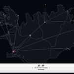
¡Un pequeño side project que he hecho durante las vacaciones!
Un mapa interactivo de los vuelos domésticos en Islandia desde octubre hasta diciembre.
serranowski.github.io/icelan…

¿El inconveniente? La información es estática; es decir, no hay forma -que yo sepa- de actualizar en tiempo real los cambios en los horarios en caso de retrasos o cancelaciones.

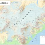
El glaciar Vatnajökull cubre aproximadamente el 8% de Islandia, creando un sobrecogedor paisaje de hielo que entierra volcanes activos bajo su superficie. El mapa muestra la elevación del glaciar y la concentración de grietas por zonas.

Un placer el ratito que pasamos en el sureste, Jon. Por más y mejores días de fuego y hielo.
This Post is from an account that no longer exists. Learn more
November means #30DayMapChallenge.
Stuck on a theme or just want new ideas?
This small tool I built generates map briefs to help you overcome the feared creativity drought and get started:
gis-brief-generator.vercel.a…
Happy mapping! 🗺️
More details here! 👇🏻
xitter.cf/serranowski/status/189…

J.J. Serrano retweeted

Tatra Mountains, highest range of the Central Carpathians, located on the border of Slovakia and Poland. #tatramountains #qgis #tatry


I made this map of Suðursveit (although I want to think of it as a postcard) based -roughly- on a tutorial by @pinakographos.

No, not that Blender tutorial. This one: somethingaboutmaps.wordpress…

Stuck on your next GIS project? I have been working for the last few weeks on a little side project: a creative GIS generator based on React that will help you break through any creative block and explore new ideas.
This is GIS Brief Generator! 📄

Select your map type (you can choose between Topographic, Political, Choropleths, Dots, Physical or Transit), your map scope and click Generate.
That's it. That easy.
The tool will give you a brief and its deadline.
On the following link you have the full code available in Github:
github.com/Serranowski/gis-b…
I hope it helps all GIS professionals going through a creative drought to find interesting ideas for their next projects.
Do not hesitate sharing your feedback and outcome!

