
Engineer @wonderschools | @wisalumni ‘25
San Francisco, CA
Joined November 2019
- Tweets69
- Following206
- Followers27
- Likes584


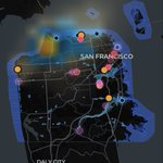





flood map changelog since launch:
- opens in 0.1s (was 8s)
- says "retrying" instead of showing an empty map that reads like "no flooding"
- a fresh flood photo makes an area at least moderate risk
- NWS alerts + CHP road flooding now count toward risk
- "last 30 min" filter

SF is flooding. I built a live map of it in ~2 hours with Claude Code + @Grok
@SpaceXSI’s Grok vision reads street signs and storefronts in flood photos on X to figure out where each was taken, then maps them over NWS alerts, tides and SFPUC/FEMA risk zones
sf-floodwatch.vercel.app


1
1
80
shipped some of the boring useful stuff on the sf flood map:
- nearest sandbag site + whether it's open rn (marina green + ocean beach pop-ups sat)
- one tap to report flooding to 311 (911 if it's an emergency)
- help sheet with how to sign up for AlertSF
no posts ≠ no flooding tho

SF is flooding. I built a live map of it in ~2 hours with Claude Code + @Grok
@SpaceXSI’s Grok vision reads street signs and storefronts in flood photos on X to figure out where each was taken, then maps them over NWS alerts, tides and SFPUC/FEMA risk zones
sf-floodwatch.vercel.app
1
113


Update: people kept reposting the same flood clips and it was turning the map into confetti 😆
now grok tags every post with the incident it's about, so yesterday's ~3 reposts of the waymo stuck on oak st = 1 pin
SF is flooding. I built a live map of it in ~2 hours with Claude Code + @Grok
@SpaceXSI’s Grok vision reads street signs and storefronts in flood photos on X to figure out where each was taken, then maps them over NWS alerts, tides and SFPUC/FEMA risk zones
sf-floodwatch.vercel.app
1
2
110
SF is flooding. I built a live map of it in ~2 hours with Claude Code + @Grok
@SpaceXSI’s Grok vision reads street signs and storefronts in flood photos on X to figure out where each was taken, then maps them over NWS alerts, tides and SFPUC/FEMA risk zones
sf-floodwatch.vercel.app
How it works:
@X API search for flood photos → Grok vision pulls neighborhood, cross street, severity + confidence from the text and photo → geocode → MapLibre on Vercel
Same flood reposted 3x = 1 pin. If the live feed fails it shows a cached snapshot, not an empty map
2
50
How to read it:
🩷 Pink: flood photos from X, located by Grok
🟣 Purple: news reports
🟡 Amber: NWS alerts, rain, tides, radar
🔵 Blue: SFPUC + FEMA flood-risk zones
Tap a pin → photo, how it was located, confidence+link
Tap a neighborhood → Low/Mod/High risk + why
3
102


caught spotlight at 84% CPU indexing 119,329 package.json files on my mac lol
100+ worktrees with coding agents editing files all day will do that 😭
fix: gist.github.com/sid-valecha/…

2
79


