

This @wanewx account is home to local forecast information from the WANE Live Doppler 15 Fury Storm Team.
Fort Wayne, Indiana
Joined February 2012
- Tweets30K
- Following149
- Followers11.4K
- Likes2K


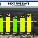

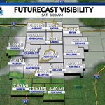


Warm weather hangs around for another week. That includes Halloween temperatures will be around 70 for trick or treating, and the rain holds off until after midnight. Enjoy the mild evening! 😉 [Link in bio]

Halloween is this upcoming Saturday. But, some may argue that the scariest part of the weekend will be the end of Daylight Savings Time! Halloween will be our last day of 2026 with a 6 PM sunset as we fall back an hour Sunday morning. [Link in bio] #15Fury

An unbelievable final week of October ahead! 🍂☀️
Highs stay in the 70s for much of the week when the average high is only 60°. Even Halloween looks mild and more like September than late October. 🎃😎 [Link in bio]

Dense fog is still impacting parts of the region this morning. The advisory is set to expire at 11 a.m., use extra caution on the roads! Visibility will improve as the fog clears, giving way to mostly sunny skies and afternoon temperatures.

Mother Nature is keeping this weather pattern on repeat. We're tracking yet another morning where patchy dense fog will be around. Some will see visibilities of a mile or less, especially around sunrise Saturday. [Link in bio] #15Fury

The warmest stretch of weather in the forecast is on the way. Highs will climb into the 70s through the weekend and continue into Monday, running 10 degrees or more above average for late October. Enjoy it while it lasts because cooler air returns early next week. 🍂☀️

WANE 15 Weather retweeted

Congrats to Ruby for being this week's umbrella winner! Enter our WANE contests at [Link in bio]

After some morning fog patches, Friday will become sunny and above average, again. The potential for fog that's more widespread comes Saturday morning. Check the WANE Forecast details: wane.com/weather


Wondering about the weekend? Good news... this beautiful weather isn’t going anywhere! ☀️😎
In fact, it’ll be even warmer, with highs in the lower to mid 70s. Not bad at all for late October

Patchy dense fog will redevelop in spots Thursday morning, resulting in some reduced visibilities across some locations around the rush hour commute. Be sure to exercise caution if you drive through the densest fog. [Link in bio] #15Fury

High pressure remains in place over the coming days. This means more mild weather and sunshine! Highs will range around 70, with more brisk mornings on tap. Get the latest forecast at [Link in bio] #15Fury

October apparently forgot it’s October. 😎🍂
Average highs are in the lower 60s, but we’ll keep enjoying lower to mid 70s through the weekend.
Early next week, reality comes knocking. Highs fall back into the lower 60s.

Areas of patchy dense fog will be possible Wednesday morning, reducing visibility in parts of the area. Otherwise, your Wednesday will be pleasant with mild temperatures reaching the upper 60s and partly cloudy skies. [Link in bio]

Not much to complain about in the forecast. 😎 Plenty of sunshine and temperatures running above average will continue through the week. The quiet pattern holds on until next week, so soak up this taste of fall while you can.
[Link in bio]

Dry conditions will continue through the workweek with plentiful sunshine Tuesday, Wednesday, and Thursday. High temperatures remain above average in the upper 60s, with Thursday reaching near 70. Overnight lows fall to the lower 40s. [Link in bio]

☀️ Sunshine and a steady flow of mild air from the southwest will keep the fall chill away! Highs will flirt with 70 each day through the weekend. 😎🍂 [Link in bio]

Another chilly night is ahead! Clear skies and calm winds set up another chance for some frost Monday morning, as lows drop into the mid-to-upper 40s. You'll want the jacket heading out to work, and for the kids getting on the bus. [Link in bio] #15Fury

It's a chilly Sunday morning with temperatures in the 30s to start the day! Skies are clear with plenty of sunshine, which will continue through the day. Our high temperatures will be seasonable today, reaching the lower 60s. Check out the full forecast at [Link in bio]

Our first freeze of Fall is on the way! Lows drop to around the freezing mark under clear skies Sunday morning. A Freeze Warning is in effect for all of northeast Indiana and northwest Ohio. Get the latest forecast at [Link in bio] #15Fury

