Meteorologist Fallon Mears retweeted
All roads and intersections within the City that were closed due to tonight’s storm have now been reopened. Thank you for your patience and cooperation.
Meteorologist Fallon Mears retweeted
Numerous road and intersection closures in the downtown area. Drive with continued caution until standing water drains and obey all officers directing traffic.
Turn Around and Don’t Drown
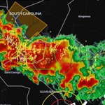
Here are some reports from the slow-moving storm that made it from Georgetown to St. George... Anyone see any damage or flooding? Y'all are my eyes on the ground - pictures or videos would be greatly appreciated!
(8:30pm 7/6/2026) FLASH FLOOD WARNING FOR BERKELEY & DORCHESTER COUNTIES UNTIL 11:15PM. 2-4” have fallen & additional 1-2” is possible in the warned area. Flash flooding is possible for small creeks, urban areas, low lying streets, hwys, & other poor drainage areas. #chswx
Meteorologist Fallon Mears retweeted
A DIVINE SIGN: 131 mph winds were recorded in Highmore, SD early Monday morning (June 29th) and were strong enough to split the roof of a local Catholic church, allowing the sun to highlight the church's crucifix after the storms passed.
The winds are the second strongest ever recorded in the state, just shy of the record of 136 mph. #SDwx
A Heat Advisory has been issued for Berkeley, Charleston, and Coastal Colleton Counties from noon until 6pm today. Heat indices are expected to reach 108. Stay hydrated & cool y’all!!#chswx
Meteorologist Fallon Mears retweeted
At 10:15 am, @ShoreBeachSvc reported a waterspout off the coast from the Singleton Beach area. Did anyone see it and happen to get a picture? Additional waterspout development is possible. Please pass along any sightings and pictures. #scwx
Special Marine Warning including the Waters from Edisto Beach SC to Savannah GA extending from 20 to 60 NM and Coastal waters from Edisto Beach SC to Savannah GA out 20 NM until 12:30 PM EDT

ALT This graphic displays a special marine warning plotted on a map. The warning is in effect until 12:30 PM EDT. The warning includes waters from Edisto Beach SC to Savannah GA extending from 20 to 60 NM and coastal waters from Edisto Beach SC to Savannah GA out 20 NM. The threats associated with this warning are wind gusts greater than 34kts and no hail expected.Waterspouts are observed. Steep waves can be expected. Seek safe harbor and take protective actions.
Area to watch in the Gulf. It has a very low chance of developing with a low pressure system trying to form over the Bay of Campeche late this week. It is forecasted to move inland to eastern Mexico with some rainfall. No need to fear - we are always watching! #tropics
6.1 Earthquake in the Gulf near Cuba roughly around 2:00pm today. Heard some people felt it in Florida!
Meteorologist Fallon Mears retweeted
Heads up beachgoers! While it will be nice and sunny tomorrow, albeit a bit breezy, there is a high risk of rip currents expected. The surf zone is expected to be dangerous, therefore residents and visitors are strongly urged to stay out of the surf!
(6/1/26) *FLASH FLOOD WARNING FOR BERKELEY, CHARLESTON, & DORCHESTER COUNTIES UNTIL 12:15AM*
1-3" may fall in this cluster of showers & tstorms with downpours, combined with high tide at 9:42pm. Road closures are likely & water may enter buildings. Avoid flooded roads. @ABCNews4
(6/1/26 9:08PM) SPECIAL WEATHER STATEMENT FOR BERKELEY AND DORCHESTER COUNTIES
Radar has indicated wind gusts up to 50 mph that could knock down limbs & blow around unsecured objects. There's some lightning in there as well! #chswx
Video from one of my buddies in Downtown Charleston. Says the water was above his knees in some areas!
@ABCNews4
🎥 Seth Twisdale
Meteorologist Fallon Mears retweeted
UPDATE: @NASA can confirm a fireball over New England at 2:06 p.m. EDT on Saturday, May 30, 2026. The meteor was about 5 feet (1.6 meters) in diameter with a mass of 5.6 metric tons and entered Earth’s atmosphere at roughly 42,000 mph.
The meteor traveled through the atmosphere from northwest to southeast for 26 miles before breaking up at an altitude of 31 miles and producing a meteorite fall into Cape Cod Bay.
Based on the latest data, the energy released at breakup is estimated to be equivalent to about 230 tons of TNT, which accounts for the sonic boom.
Have questions? Check out our fireball FAQs: go.nasa.gov/4mtUQuX
#MeteorSighting: Eyewitnesses in New England and @NOAA’s GOES-19 satellite reported a bright fireball on Saturday, May 30, at 2:06 p.m EDT accompanied by a loud noise. The meteor appears to have fragmented at an altitude of 40 miles over northeast MA and southeast NH. The energy released at breakup is estimated to be equivalent to about 300 tons of TNT, which accounts for the loud noise.
Eyewitness accounts supplied by the American Meteor Society.
Anyone seeing any flooding? Especially in Downtown Charleston. King St @ Huger St is closed due to flooding from excessive rainfall. #chswx #chstraffic
Meteorologist Fallon Mears retweeted
A Flood Advisory has been issued for the Downtown Charleston peninsula through 6:45 PM. Showers and storms could drop a quick 1 to 1.5 inches of rain through 5:30 PM. Remember - turn around, don't drown! #chswx
Coastal Flood Advisory is in effect for Coastal Colleton and Charleston Counties until 11pm. Minor coastal flooding is possible. #chswx