

Plants, people & climate change, past, present & future. Husband, dad, and NERC Knowledge Exchange Fellow @YorkEnvironment, having fun with @3DPollenProject.
- Tweets7.1K
- Following629
- Followers580
- Likes517





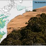

ALT Uma imagem combinada intitulada “O mosaico Floresta de Araucária-Campos”. À esquerda está um mapa do sul do Brasil. As áreas verdes mostram a cobertura potencial natural da Floresta com Araucária, as áreas amarelas mostram o mesmo para os campos naturais, e as áreas sombreadas mais escuras mostram as pequenas áreas de vegetação natural remanescente nessas regiões. Um mapa no canto inferior direito mostra a localização na região sul e sudeste do Brasil. No centro e à direita, uma foto (Matthieu Struck, https://www.flickr.com/photos/mathieustruck/3863274971/). Em primeiro plano, da esquerda para a direita, há uma floresta verde-escura com algumas árvores emergentes e, em segundo plano, campos beges cobrindos o topo de uma colina sob um céu azul sem nuvens.

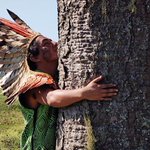
ALT Um homem indígena com um cocar de penas abraça o grande tronco de uma araucária num campo. Foto de Juan Todescatt/NSC TV via https://g1.globo.com/sc/santa-catarina/noticia/2022/06/15/temendo-extincao-da-araucaria-indigenas-de-sc-reflorestam-territorio-com-arvore-sagrada.ghtml

ALT Três mulheres indígenas em frente ao tronco de uma araucária. Sobreposto está o logotipo - um desenho de duas mulheres, ligadas por um desenho indígena, com araucárias estilizadas saindo de suas cabeças, e as palavras “Mulheres Araucárias” abaixo. De https://www.youtube.com/watch?v=MLTok0Kb86M


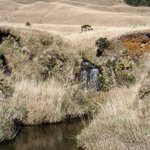
ALT A river runs through a natural landscape. At left and centre, beige grasslands cover the valley slopes and hillsides to the horizon. On the right, dark green forest covers the shaded valley slope. Photo by Marcos Przygocki/Fotografo Terapeuta (https://commons.wikimedia.org/wiki/File:Aparados_da_serra_Marcos_Przygocki_09.jpg)

ALT A map showing remaining natural grassland and forest in southern Brazil’s Araucaria Forest-Campos mosaic region, with pink outlines showing the locations of protected areas.

ALT Five satellite images showing much more forest (dark green) within Indigenous Territories (purple outlines) than outside, where the landscape is predominantly a patchwork of light green and brown fields.

ALT An Indigenous man with a feathered headdress embraces the large trunk of an Araucaria tree in a field. Photo by Juan Todescatt/NSC TV via https://g1.globo.com/sc/santa-catarina/noticia/2022/06/15/temendo-extincao-da-araucaria-indigenas-de-sc-reflorestam-territorio-com-arvore-sagrada.ghtml

ALT Three Indigenous women stand in front of the trunk of an Araucaria tree. Superimposed is a logo – a drawing of two women, linked with an Indigenous design, with stylised Araucaria trees emerging from their heads, and the words ‘Mulheres Araucárias’ (‘Araucaria Women’) below. From https://www.youtube.com/watch?v=MLTok0Kb86M

ALT A combined image entitled ‘The Araucaria Forest-Campos mosaic’. On the left is a map of southern Brazil. Green areas show the natural potential coverage of Araucaria Forest, yellow areas show the same for natural Campos grasslands, and darker shaded areas show the small areas of remaining natural vegetation in these regions. An inset map at lower right shows the location in the southern and south-eastern region of Brazil. At centre and right is a photo (Matthieu Struck, https://www.flickr.com/photos/mathieustruck/3863274971/). In the foreground from bottom left to top right is dark green forest with some emergent trees, and in the background is beige grassland covering a hilltop beneath cloudless blue sky.