

Engineer & Scientist • Chasing Water, Unraveling 🌎 Mysteries • 📺 @weatherchannel• @discovery • @natgeo • 📚@sos.comicbook•@marvel Agent GIRL
Earth...most of the time
Joined February 2014
- Tweets22.5K
- Following11.7K
- Followers14.7K
- Likes32.6K





Pinned Tweet
Here it is! A reel of how we want 2 bring real, exciting scientific investigation, experimentation & discovery 2 the public while getting them involved! W/ @UF @TayKatBat @Nick_H_Engineer @dacia92 this was created for a grant application & modified to protect grant ideas #science
Tracy Fanara, Ph.D. retweeted

🔥 🇺🇸 U.S. Ocean Tech is on FIRE 🇺🇸🔥
@NOAA @usioosgov just released the latest data (through 2025) on the BOOMING “Ocean Enterprise”, which is a business cluster made up of companies, entrepreneurs, and service providers that supply technology to generate ocean data or work with ocean information.
That business cluster provides massive economic, societal, and environmental benefits to the country.
Key Highlights:
- 🇺🇸 Ocean Enterprise (OE) businesses generate $16.4 BILLION in annual revenue, a ~50% increase since 2020
- The number of business in the OE cluster grew by almost 75% since 2020
- The total number of jobs in the OE cluster grew … drum roll please 🥁… from 325,000 jobs in 2020… to ✨2.4 MILLION jobs in 2025 ✨
Check out the full report below👇🏻

The U.S. Ocean Enterprise is 1,830 businesses strong! They support the rising demand for ocean and Great Lakes data & information — read more in The U.S. Ocean Enterprise in 2025 report! oceanservice.noaa.gov/news/o…

ALT Ship crew on the bridge are silhouetted against a sunset at sea with multiple information and data screens visible inside.
Yesss! So psyched for @chaser_summit !!!!

We are excited to announce @inspectorplanet as a speaker at this years summit! Get your tickets today! The price will go up soon!


Come join me for Unexplained Science at the Sharon in the villages on Thursday, October 15 at 7 PM. We are going to explore some of our planet’s mysteries!
Get your tickets at the link below… Plenty of seats… Please help me fill them!
thesharon.com/event/dr-tracy…
Tracy Fanara, Ph.D. retweeted

The Dominator weather balloon soared to above 50,000 feet inside the eye of Hurricane Isaias thank you to the work of @WillClay25


COME JOIN ME AT THE SHARON IN THE VILLAGES THURSDAY NIGHT!
thesharon.com/event/dr-tracy…


Tracy Fanara, Ph.D. retweeted

From the City of Gulf Shores
𝗚𝗢𝗩𝗘𝗥𝗡𝗢𝗥 𝗞𝗔𝗬 𝗜𝗩𝗘𝗬 𝗜𝗦𝗦𝗨𝗘𝗦 𝗠𝗔𝗡𝗗𝗔𝗧𝗢𝗥𝗬 𝗩𝗜𝗦𝗜𝗧𝗢𝗥 𝗘𝗩𝗔𝗖𝗨𝗔𝗧𝗜𝗢𝗡
Alabama Governor Kay Ivey has issued an executive proclamation declaring a mandatory evacuation for all non-residents, tourists, and visitors in Alabama coastal areas, effective immediately as of 2:30 p.m. CDT today, October 8, 2026, due to the threat of Hurricane Isaias.
𝗪𝗵𝗼 𝗶𝘁 𝗮𝗳𝗳𝗲𝗰𝘁𝘀: All non-residents, visitors, and tourists.
𝗔𝗳𝗳𝗲𝗰𝘁𝗲𝗱 𝗔𝗿𝗲𝗮𝘀: All Baldwin County areas south of the Intracoastal Waterway, including the City of Gulf Shores and the City of Orange Beach.
𝗗𝘂𝗿𝗮𝘁𝗶𝗼𝗻: In effect until the state of emergency expires or is modified.
All visitors currently staying south of the Intracoastal Waterway, including the City of Gulf Shores and the City of Orange Beach, should make immediate preparations to safely evacuate the area.
Tracy Fanara, Ph.D. retweeted


We are so lucky to have the expertise of @blamarre in Tampa Bay! Great job on @foxweather !


The Airforce Hurricane Hunters 53rd Weather Reconnaissance Squadron is about to take off into #Isaías following Mission 8 by the NOAA Hurricane Hunters (yes- 2 different teams with different missions). I had the opportunity to go into one of the C130s and spoke to @JeremyDeHartWX about his job as a hurricane hunter @53rdWRS
Tracy Fanara, Ph.D. retweeted

We have an unusually High #Tornado Threat from #Hurricane Isaias
This movie uses real data, to help educate on why this storm poses an enhanced risk. Notice the yellow vs blue arrows. Yellow are the winds just below the clouds, it’s the low level wind flow (jet) around and feeding into the storm. Blue are the mid-level winds associated with the jet stream. You’ll notice that as Isaias approaches the Gulf Coast the blue arrows increase and the low-level vs mid-levels winds vigorously cross (X) each other. That’s the jet stream (blue arrows) being infused into the tropical system. That will create more cross winds/ shear, weaken #Isaias, but embolden spin in the outer bands. This injection of energy will power strong #tornadoes on the storm’s east side at landfall in the #Florida Panhandle and beyond into the Southeast. Not all storms have this, but it’s more common in fall as the mid-latitude jet stream increases. And it gives the transitioning tropical storm system a different character. It causes the wind field at the core to expand, making the storm larger, empowering the outer bands with more wind, at the expense of the core winds which weaken. (Although all set ups are different, Milton and Sandy come to mind)
*This animation does use real wind data, but the tornadoes are added to illustrate where the greatest risk is. They are not meant to forecast exactly where the tornadoes will be.

Excellent interview with @kiyanalewiswx, Dr. Tracy Fanara @inspectorplanet, with @foxweather discussing developing #hurricane #isaias and the expected impacts across the area - both inside and outside the “cone” of uncertainty. #flwx


Nice timing in this- so these are Kelvin-Helmholtz waves- a local atmospheric phenomenon that almost all of my meteorologist friends assumed I was talking about when I spoke about the oceanic Kelvin waves which are large scale planetary boundary waves driven by El Niño and the Coriolis effect, causing a rise in coastal sea levels that you may be hearing about in Southern California


Tracy Fanara, Ph.D. retweeted

🔧Heads up: MOB & KEVX Radars remain offline this morning until further notice. Technicians have been noticed and we'll provide an update when the radars return online.

ALT KMOB and KEVX Radar Outage: Both radars remain offline until further notice.
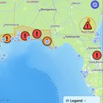
Not great timing for radar to go down. Hopefully observations will be assimilated to alert the public in these areas of risks as major rain comes through. The National Water Center updates their flood inundation map (area around rivers where water will reach) and flood projections based on gauge data.
I’ve been working on a very helpful app called FloodAware with Project ENKI @project_enki and King developers that hasn’t been published yet. I’ll try to keep posting with hydrologic updates.
Improving precipitation forecasts (specifically the physics models; AI is helpful but I feel more secure when we understand the science) is essential.
In the attached picture, you see where the flash flood and flood warnings are, you’ll see the light blue tide gauges and the river gauges appear as you zoom in. Unknown state means that there is no official information on thresholds for slight, moderate, and severe flooding, but the gauges still show the water depth. This apple also allow for community reporting of flooding.


This has never happened in my career. All three of our primary NEXRAD weather radars are down this morning. Closest radar that is working is at Maxwell AFB near Montgomery.
@NWSMobile says it’s a communication issue with the radars.
Hopefully these vital radars will be restored soon as rain is expected throughout the day. Thankfully, widespread severe weather remains unlikely.
