

Meteorologist in Florida | Penn State Meteorology | Husband & Father | Florida Native
Florida
Joined July 2012
- Tweets43.1K
- Following2.8K
- Followers75.6K
- Likes61.7K




Matt Devitt retweeted

Large stovepipe tornado captured north of Heber-Overgaard, AZ 15 minutes ago with @RealDLScales

TROPICAL UPDATE: Subtropical Storm #Josephine has formed in the Atlantic, 10th named storm of the 2026 Atlantic Hurricane Season. Even though it won't be making landfall in the United States as it heads northeast, it'll still bring some gusty wind, coastal flooding and dangerous surf for sections of the Mid-Atlantic up to New England today and tomorrow. What is a subtropical storm? Here is the difference between a tropical vs subtropical vs extratropical low!

Contrary to popular belief, the NHC doesn’t just name storms to hit the pre-season total. I see that a lot online, it’s false. If it reaches the criteria to become a tropical / subtropical storm, it gets classified. Simple as that. Tomer does a great job below explaining why the Atlantic low became Josephine today.


Matt Devitt retweeted

We finally got a (partial) ASCAT pass that hit #93L. This looks like it's probably a subtropical storm, in my opinion. It looks pretty detached from the fronts on the southwest side of the circulation, and has core convection and a fairly small RMW on the NW side. It's a little hard to tell for sure on the NE side since we didn't get a pass there just yet.
Regardless of the classification, strong NE winds will affect the eastern seaboard.

FALL FOLIAGE! 🍁🌈 Absolutely amazing color right now along the Blue Ridge Parkway In North Carolina. Best shots I've seen so far with a bonus rainbow too! Credit: Bryan Harrell


THE SUNSHINE STATE! ☀️ Have you noticed the awesome, crystal blue sky recently across Florida? We have a lot of dry air aloft (brown color below) that helps to clear the sky and lead to a lot of sun. Enjoy!
CHILLY MORNING again across northern Florida with some *almost* reaching the upper 30s. Suwannee Springs just outside of Live Oak reached 40 degrees. Tallahassee 42. Even upper 50s in Daytona and Lakeland!

$14 tickets for a home Penn State game at Beaver Stadium is wild. 😬💀


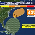
TROPICAL UPDATE: No significant changes to the area of low pressure in the Atlantic. Odds remain at 40%. The CPC (not pinned yet by the NHC) has an area near or north of the Bahamas towards late Oct / early Nov. Some support actually from the European Model (physics-based) and Google (AI). Just watching, still plenty of time to see if anything changes. I'll keep you posted.

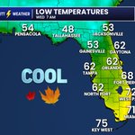
COOL START again tomorrow morning for most of Florida. Chilly 40s in the Panhandle, 60s in Central Florida Wednesday morning. Enjoy!

EL NIÑO UPDATE: New numbers indicate that this El Niño is in fact the #1 strongest and warmest by surface water temps in the Pacific (Nino 3.4 Region). They are currently +3.3°C / +5.9°F above normal! Even NOAA's metric called RONI (Relative Oceanic Niño Index) is tied for the #1 warmest El Nino and should break the all-time record very soon in the weeks ahead.
FLORIDA IMPACTS: With the exception of Hurricane Isaias, one of the more positive impacts is currently happening this hurricane season (along with greater than normal stability levels). El Niño typically increases wind shear across the tropical Atlantic and makes it more difficult for tropical systems to organize and intensify. We're almost towards the end, hang in there!
The larger Florida impacts would be more noticeable as we move deeper into fall and especially winter, when El Niño’s influence on the jet stream is normally strongest. During El Niño, the subtropical jet stream tends to become stronger and shift farther south, steering more disturbances and Gulf low-pressure systems across Florida and the Southeast.
For Florida, that historically means a winter that is wetter, stormier, cloudier, and cooler…mainly with afternoon temperatures. Currently the European Model is showing a cooler than average winter for Florida many across the Southeast (pictured). Unfortunately, Florida’s severe weather potential does increase too. The two strong El Niño events of 1982-83 and 1997-98 produced significant severe weather and even tornado outbreaks. That doesn't mean a tornado outbreak is inevitable this winter, but if this El Niño becomes as strong as forecast, there could be several severe weather threats in the months ahead.
Will it snow in Florida this winter? North Florida and the Panhandle always have a small opportunity each year if the right cold outbreak and Gulf storm overlap. For Central or South Florida, it’s harder to get that perfect set-up. El Niño makes an active southern storm track that brings in the moisture, but what it does not guarantee is the other ingredient…cold Arctic air. If they join together, it is something we probably won't know until days beforehand. It’s not impossible though! Florida’s famous January 19, 1977 snow event occurred during an El Niño winter. Snow flurries were observed from Palm Beach and Miami all the way south to Homestead…the farthest south snow has been documented in Florida.
I’ll continue to get you the very latest as information comes in. Thanks all!
- Matt Devitt WINK Weather


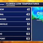
BRRR! Florida almost recorded their first 30s of the season this morning. Crestview once again the coldest statewide at 41. Chilly in Tallahassee reaching 44! 🥶

The number of “the rocket is hitting the firmament dome” conspiracy theories on Jellyfish cloud days is honestly disturbing. The rocket is frequently over a million pounds with fuel and traveling as fast as 17,000+ mph, it’s not scrapping up against a barrier lol. It’s going into Space like live cams and irrefutable evidence have shown. Makes me want to open up a science book ASAP with my toddlers reading some of these comments. 🙃

JELLYFISH CLOUD! 🚀 New pictures coming in from the SpaceX launch this morning across Florida and parts of the Southeast! It has this unique look because the rocket and the plume are high enough above Earth that it’s illuminated by sunlight, but down near the ground for us it's still dark before sunrise. If you have a picture, feel free to share!


JELLYFISH CLOUD! 🚀 New pictures coming in from the SpaceX launch this morning across Florida and parts of the Southeast! It has this unique look because the rocket and the plume are high enough above Earth that it’s illuminated by sunlight, but down near the ground for us it's still dark before sunrise. If you have a picture, feel free to share!
Matt Devitt retweeted

Liftoff 7:04 AM 10-20-26 #SpaceX #Bandwagon5 with #Starfall Demo & B1085-19. 🇺🇲🚀🇺🇲
By Scott Schilke for sipausa.com and spacenewsfl.com – at St Lucie Village, FL


TROPICAL UPDATE: Odds now up to 40% for an area of low pressure in the Atlantic. Next name is #Josephine. If the system can lose its attached fronts, it has a window of time to potentially become a hybrid "subtropical" storm. Google's 1000-member ensemble is currently giving this a 3% chance of landfall or a 97% chance it stays far enough away. Even staying offshore, however, can still bring gusty wind, some coastal flooding and dangerous surf from the Carolinas all the way up to New England.

Matt Devitt retweeted

Another SpaceX launch is scheduled for 6:30 AM Monday, but don’t expect a repeat of last week’s spectacular show.
This rocket will head southeast from Florida, away from the Carolinas. Last week’s launch traveled northeast up the East Coast, giving us a much better view of that gorgeous glowing plume.
We may catch a glimpse toward the south or southeast, but anything visible would likely stay very low near the horizon, with any illuminated plume much farther away. If you’re up, it’s worth a look. For me, I’m sleeping in.
🚀🚀🚀
