Nick & Amanda Elms πŸŒͺοΈπŸŒ©οΈπŸ“·πŸŽ₯🌽 (@PrairieWindWX) header
Nick & Amanda Elms πŸŒͺοΈπŸŒ©οΈπŸ“·πŸŽ₯🌽 (@PrairieWindWX) profile picture

Documenting all things Extreme Weather and Nature through Photography and Video and working to Protect Lives and Property. NWS Weather Ready Nation Ambassadors

West Central, Minnesota
Joined March 2013
Photo by Nick & Amanda Elms πŸŒͺοΈπŸŒ©οΈπŸ“·πŸŽ₯🌽 (@PrairieWindWX)Photo by Nick & Amanda Elms πŸŒͺοΈπŸŒ©οΈπŸ“·πŸŽ₯🌽 (@PrairieWindWX)Photo by Nick & Amanda Elms πŸŒͺοΈπŸŒ©οΈπŸ“·πŸŽ₯🌽 (@PrairieWindWX)Photo by Nick & Amanda Elms πŸŒͺοΈπŸŒ©οΈπŸ“·πŸŽ₯🌽 (@PrairieWindWX)Photo by Nick & Amanda Elms πŸŒͺοΈπŸŒ©οΈπŸ“·πŸŽ₯🌽 (@PrairieWindWX)Photo by Nick & Amanda Elms πŸŒͺοΈπŸŒ©οΈπŸ“·πŸŽ₯🌽 (@PrairieWindWX)Photo by Nick & Amanda Elms πŸŒͺοΈπŸŒ©οΈπŸ“·πŸŽ₯🌽 (@PrairieWindWX)Photo by Nick & Amanda Elms πŸŒͺοΈπŸŒ©οΈπŸ“·πŸŽ₯🌽 (@PrairieWindWX)Photo by Nick & Amanda Elms πŸŒͺοΈπŸŒ©οΈπŸ“·πŸŽ₯🌽 (@PrairieWindWX)Photo by Nick & Amanda Elms πŸŒͺοΈπŸŒ©οΈπŸ“·πŸŽ₯🌽 (@PrairieWindWX)
Nick & Amanda Elms πŸŒͺοΈπŸŒ©οΈπŸ“·πŸŽ₯🌽 retweeted
SPC has a slight risk of SEVERE thunderstorms today based on a conditional TORNADO potential. Watch for future updates as this gets fine tuned during the day. #twincities
3
10
105
31,175
Nick & Amanda Elms πŸŒͺοΈπŸŒ©οΈπŸ“·πŸŽ₯🌽 retweeted
Showers with embedded t-storms will develop over western MN early this afternoon and progress east over eastern MN into western WI through this evening. Some storms may be strong to severe, with potential for large hail, damaging winds and a few tornadoes. #mnwx #wiwx
3
7
3
69
13,462
Nick & Amanda Elms πŸŒͺοΈπŸŒ©οΈπŸ“·πŸŽ₯🌽 retweeted
think that was a weak tornado just now near Chokio, Minnesota
3
8
84
2,256
Tornado on the ground 7 miles SW of Alberta MN in SW Stevens County. Tornado was on the ground for several minutes and has caused damage to power poles and line as found so far in the darkness. #mnwx @NWSTwinCities @WeatherNation @wccowx @WCCOShaffer @fox9weather @ian_leonard
1
4
49
1,484
Measured half dollar sized hail on Traverse county road 15, 7 miles ne of Dumont, MN #mnwx @NWSAberdeen #hail
1
5
261
Nick & Amanda Elms πŸŒͺοΈπŸŒ©οΈπŸ“·πŸŽ₯🌽 retweeted
NOAA Weather Radio (NWR) is a great way to stay informed of the latest, real-time weather conditions, forecasts, and of course watches, warnings and advisories issued directly from your National Weather Service. πŸ“» Most NWRs allow you to set your location, so you’ll only receive emergency alerts for your area. And the portable NWR option is perfect for camping trips when cell phone service may be unreliable! πŸ•οΈweather.gov/nwr/ #NationalPreparednessMonth
11
81
10
240
58,386
Measured 1.00" inch Quarter Sized Hail at 3:33 p.m. Kittson Cty Rd 22 and 230th St. 6.5 miles southeast of Hallock. @NWSGrandForks #MNWX
1
2
418
Nick & Amanda Elms πŸŒͺοΈπŸŒ©οΈπŸ“·πŸŽ₯🌽 retweeted
A severe thunderstorm watch has been issued for parts of Iowa, Minnesota and South Dakota until 2 AM CDT
1
4
1
18
8,800
Nick & Amanda Elms πŸŒͺοΈπŸŒ©οΈπŸ“·πŸŽ₯🌽 retweeted
6:12pm CDT #SPC_Watch WW 443 SEVERE TSTM IA MN SD 022310Z - 030700Z, #iawx #mnwx #sdwx, spc.noaa.gov/products/watch/…
9
26
13,687
Nick & Amanda Elms πŸŒͺοΈπŸŒ©οΈπŸ“·πŸŽ₯🌽 retweeted
This was an exceptionally ferocious Mesoscale Convective System that exploded over South Dakota earlier today. The hyper-concentrated lightning core generated wind gusts akin to a Category 4 Hurricane and toppled over entire wind turbines when it ripped through Highmore.
18
129
14
1,015
86,956
Nick & Amanda Elms πŸŒͺοΈπŸŒ©οΈπŸ“·πŸŽ₯🌽 retweeted
Severe Thunderstorm Warning continues for Sisseton SD, Wheaton MN and Browns Valley MN until 9:45 AM CDT
2
3
1,297
Nick & Amanda Elms πŸŒͺοΈπŸŒ©οΈπŸ“·πŸŽ₯🌽 retweeted
The NWS Sioux Falls radar will be offline until June 30 for replacement of the radar dome panels and repainting.
2
6
3,482
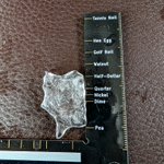
Measured 1.75 4 miles SE of Cyrus, MN on co alCo Hwy 1 @ 4:18 pm cdt (Pope County) @NWSTwinCities #mnwx
2
206
Measured gold balll sized hail 4:18 pm cdt pope county mn on Co hwy 1. @NWSTwinCities #mnwx
1
4
459
Nick & Amanda Elms πŸŒͺοΈπŸŒ©οΈπŸ“·πŸŽ₯🌽 retweeted
Tornado Warning including Laporte MN and Benedict MN until 3:15 PM CDT
6
16
1
41
6,219
Heavy blowing surface dust being lofted along the OFB 1 mile SW of Felton, MN in Clay County @ 1:20pm. This was observed with the measured 54 MPH wind gust. @NWSGrandForks #mnwx
2
297
Nick & Amanda Elms πŸŒͺοΈπŸŒ©οΈπŸ“·πŸŽ₯🌽 retweeted
After overnight thunderstorms exit Minnesota early Wednesday morning, the atmosphere will recharge for another round of potentially severe storms this afternoon and evening. Here’s what to expect. fox9.com/weather/minnesota-w…
1
1
3
1,587
Nick & Amanda Elms πŸŒͺοΈπŸŒ©οΈπŸ“·πŸŽ₯🌽 retweeted
Line of strong to severe storms extending across western & southern MN will continue to quickly move northeast across the forecast area. Attached below is an updated time of arrival graphic. Time of arrival for TC Metro: 3-4AM. Strong to severe wind gusts will be possible. #mnwx
4
7
46
13,590
Nick & Amanda Elms πŸŒͺοΈπŸŒ©οΈπŸ“·πŸŽ₯🌽 retweeted
MPX issues Severe Thunderstorm Watch till Jun 5, 11:00 PM CDT mesonet.agron.iastate.edu/vt…
3
4
171
Nick & Amanda Elms πŸŒͺοΈπŸŒ©οΈπŸ“·πŸŽ₯🌽 retweeted
We need your help! We're in the process of following up on last night's severe weather and are looking for reports of large hail or wind damage. If you have something you would like to share, feel free to comment. Bonus points if you have a few pictures. Thanks in advance!
3
8
2,240